Venango County
 | |
| Verwaltung | |
|---|---|
| US-Bundesstaat: | Pennsylvania |
| Verwaltungssitz: | Franklin |
| Adresse des Verwaltungssitzes: | County of Venango 1174 Elk Street Franklin, PA 16323 |
| Gründung: | 12. März 1800 |
| Gebildet aus: | Allegheny County Lycoming County |
| Vorwahl: | 001 814 |
| Demographie | |
| Einwohner: | 50.454 (Stand: 2020) |
| Bevölkerungsdichte: | 28,86 Einwohner/km² |
| Geographie | |
| Fläche gesamt: | 1769 km² |
| Wasserfläche: | 21 km² |
| Karte | |
 | |
| Website: www.co.venango.pa.us | |
Venango County[1] ist ein County im Bundesstaat Pennsylvania der Vereinigten Staaten. Bei der Volkszählung im Jahr 2020 hatte das County 50.454 Einwohner und eine Bevölkerungsdichte von 33 Einwohnern pro Quadratkilometer.[2] Der Verwaltungssitz (County Seat) ist Franklin.
Geschichte
Das County wurde am 12. März 1800 gebildet und am 1. April 1805 abschließend organisiert. Benannt wurde es nach dem gleichnamigen Dorf der Lenni Lenape, das an der Mündung des heutigen French River in den Allegheny River lag. Venango bedeutet ins Deutsche übersetzt „Otter“.[3]

Ein Ort im County hat den Status einer National Historic Landmark, die Ölförderanlage Drake Oil Well.[4] 19 Bauwerke und Stätten des Countys sind im National Register of Historic Places (NRHP) eingetragen (Stand 25. Juli 2018).[5]
Geographie
Das County hat eine Fläche von 1769 Quadratkilometern, wovon 21 Quadratkilometer Wasserfläche sind.
Städte und Ortschaften
|
|
Bauwerke
Bevölkerungsentwicklung
| Bevölkerungsentwicklung | |||
|---|---|---|---|
| Census | Einwohner | ± rel. | |
| 1900 | 49.648 | — | |
| 1910 | 56.359 | 13,5 % | |
| 1920 | 59.184 | 5 % | |
| 1930 | 63.226 | 6,8 % | |
| 1940 | 63.958 | 1,2 % | |
| 1950 | 65.328 | 2,1 % | |
| 1960 | 65.295 | −0,1 % | |
| 1970 | 62.353 | −4,5 % | |
| 1980 | 64.444 | 3,4 % | |
| 1990 | 59.381 | −7,9 % | |
| 2000 | 57.555 | −3,1 % | |
| 2010 | 54.984 | −4,5 % | |
| 2020 | 50.454 | −8,2 % | |
| 1900–1990[6] 2000[7] | |||

Weblinks
Einzelnachweise
- ↑ Venango County. In: Geographic Names Information System. United States Geological Survey, United States Department of the Interior, abgerufen am 22. Februar 2011 (englisch).
- ↑ U.S. Census Bureau QuickFacts: Venango County, Pennsylvania. Abgerufen am 28. August 2021 (englisch).
- ↑ Charles Curry Aiken, Joseph Nathan Kane: The American Counties: Origins of County Names, Dates of Creation, Area, and Population Data, 1950–2010. 6. Auflage. Scarecrow Press, Lanham 2013, ISBN 978-0-8108-8762-6, S. 243.
- ↑ Listing of National Historic Landmarks by State: Pennsylvania. National Park Service, abgerufen am 25. Juli 2018.
- ↑ Suchmaske Datenbank im National Register Information System. National Park Service, abgerufen am 25. Juli 2018.
- ↑ Auszug aus Census.gov. Abgerufen am 28. Februar 2011
- ↑ Auszug aus factfinder.census.gov (Seite nicht mehr abrufbar, festgestellt im August 2022. Suche in Webarchiven) Info: Der Link wurde automatisch als defekt markiert. Bitte prüfe den Link gemäß Anleitung und entferne dann diesen Hinweis. Abgerufen am 28. Februar 2011
Koordinaten: 41° 24′ N, 79° 46′ W
Auf dieser Seite verwendete Medien
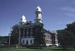
Front of the Venango County Courthouse, located at the intersection of Twelfth and Liberty Streets in Franklin, Pennsylvania, United States. Built in 1868, it is part of the Franklin Historic District, which is listed on the National Register of Historic Places.
Autor/Urheber: Niagara, Lizenz: CC BY-SA 3.0
The replica engine house and derrick of the Drake Well at the Drake Well Museum in Titusville, Pennsylvania.
|
Dieses Bild zeigt ein Objekt, das im National Register of Historic Places der Vereinigten Staaten verzeichnet ist. Die Referenznummer lautet 66000695. |
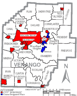
Map of Venango County, Pennsylvania, United States with township and municipal boundaries
This is a locator map showing Venango County in Pennsylvania. For more information, see Commons:United States county locator maps.


