Sullivan County (Pennsylvania)
 | |
| Verwaltung | |
|---|---|
| US-Bundesstaat: | Pennsylvania |
| Verwaltungssitz: | Laporte |
| Adresse des Verwaltungssitzes: | Sullivan County Courthouse Main and Muncy Streets Laporte, PA 18626 |
| Gründung: | 15. März 1847 |
| Gebildet aus: | Lycoming County |
| Vorwahl: | 001 570 |
| Demographie | |
| Einwohner: | 5.840 (Stand: 2020) |
| Bevölkerungsdichte: | 5,01 Einwohner/km2 |
| Geographie | |
| Fläche gesamt: | 1172 km² |
| Wasserfläche: | 6 km² |
| Karte | |
 | |
| Website: www.sullivancounty-pa.us | |
Sullivan County[1] ist ein County im Bundesstaat Pennsylvania der Vereinigten Staaten. Bei der Volkszählung im Jahr 2020 hatte das County 5840 Einwohner und eine Bevölkerungsdichte von 6 Einwohnern pro Quadratkilometer.[2] Der Verwaltungssitz (County Seat) ist Laporte.
Geschichte
Das County wurde am 15. März 1847 gebildet und nach dem General und Politiker John Sullivan benannt.[3]
Acht Bauwerke und Stätten des Countys sind im National Register of Historic Places (NRHP) eingetragen (Stand 24. Juli 2018).[4]
Geographie
Das County hat eine Fläche von 1172 Quadratkilometern, wovon sechs Quadratkilometer Wasserfläche sind.
Bevölkerungsentwicklung
| Bevölkerungsentwicklung | |||
|---|---|---|---|
| Census | Einwohner | ± rel. | |
| 1850 | 3.694 | — | |
| 1860 | 5.637 | 52,6 % | |
| 1870 | 6.191 | 9,8 % | |
| 1880 | 8.073 | 30,4 % | |
| 1890 | 11.620 | 43,9 % | |
| 1900 | 12.134 | 4,4 % | |
| 1910 | 11.293 | −6,9 % | |
| 1920 | 9.520 | −15,7 % | |
| 1930 | 7.499 | −21,2 % | |
| 1940 | 7.504 | 0,1 % | |
| 1950 | 6.745 | −10,1 % | |
| 1960 | 6.251 | −7,3 % | |
| 1970 | 5.961 | −4,6 % | |
| 1980 | 6.349 | 6,5 % | |
| 1990 | 6.104 | −3,9 % | |
| 2000 | 6.556 | 7,4 % | |
| 2010 | 6.428 | −2 % | |
| 2020 | 5.840 | −9,1 % | |
| Vor 1900[5] | |||

Städte und Ortschaften
|
|
Weblinks
Einzelnachweise
- ↑ Sullivan County. In: Geographic Names Information System. United States Geological Survey, United States Department of the Interior, abgerufen am 22. Februar 2011 (englisch).
- ↑ U.S. Census Bureau QuickFacts: Sullivan County, Pennsylvania. Abgerufen am 28. August 2021 (englisch).
- ↑ Charles Curry Aiken, Joseph Nathan Kane: The American Counties: Origins of County Names, Dates of Creation, Area, and Population Data, 1950–2010. 6. Auflage. Scarecrow Press, Lanham 2013, ISBN 978-0-8108-8762-6, S. 293.
- ↑ Suchmaske Datenbank im National Register Information System. National Park Service, abgerufen am 24. Juli 2018.
- ↑ U.S. Census Bureau _ Census of Population and Housing. Abgerufen am 28. Februar 2011
- ↑ Auszug aus Census.gov. Abgerufen am 28. Februar 2011
- ↑ Auszug aus factfinder.census.gov (Seite nicht mehr abrufbar, festgestellt im Januar 2023. Suche in Webarchiven) Info: Der Link wurde automatisch als defekt markiert. Bitte prüfe den Link gemäß Anleitung und entferne dann diesen Hinweis. Abgerufen am 28. Februar 2011
Koordinaten: 41° 27′ N, 76° 31′ W
Auf dieser Seite verwendete Medien
Autor/Urheber: User:Ruhrfisch, Lizenz: CC BY-SA 3.0
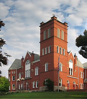
Sullivan County Courthouse, built 1894, in Laporte, Pennsylvania, United States
This is a locator map showing Sullivan County in Pennsylvania. For more information, see Commons:United States county locator maps.
Map of Sullivan County with township and municipal bondaries is taken from US Census website [1] and modified by User:Ruhrfisch in August 2005. My modifications licensed under the GNU Free Documentation License.
Source: US Census website [2], modified by User:Ruhrfisch


