Lackawanna County
 | |
| Verwaltung | |
|---|---|
| US-Bundesstaat: | Pennsylvania |
| Verwaltungssitz: | Scranton |
| Gründung: | 13. August 1878 |
| Gebildet aus: | Luzerne County |
| Demographie | |
| Einwohner: | 215.896 (Stand: 2020) |
| Bevölkerungsdichte: | 181,73 Einwohner/km2 |
| Geographie | |
| Fläche gesamt: | 1203 km² |
| Wasserfläche: | 15 km² |
| Karte | |
 | |
| Website: www.lackawannacounty.org | |
Lackawanna County[1] ist ein County im Bundesstaat Pennsylvania der Vereinigten Staaten. Im Jahr 2020 hatte das County 215.896 Einwohner und eine Bevölkerungsdichte von 182 Einwohnern pro Quadratkilometer.[2] Der Verwaltungssitz (County Seat) ist Scranton.
Geschichte

Das County wurde am 21. August 1878 gebildet. Der Hintergrund der Benennung ist nicht vollständig geklärt, wahrscheinlich stammt es vom delawarischen Begriff lechauhanne ab, der „sich gabelnder Fluss“ bedeutet.[3]
Im County liegt eine National Historic Site, die Steamtown National Historic Site. Ein Ort hat den Status einer National Historic Landmark, das Terence V. Powderly House.[4] 32 Bauwerke und Stätten des Countys sind im National Register of Historic Places (NRHP) eingetragen.[5]
Geographie
Das County hat eine Fläche von 1203 Quadratkilometern, wovon 15 Quadratkilometer Wasserfläche sind.
Städte und Ortschaften

| Bevölkerungsentwicklung | |||
|---|---|---|---|
| Census | Einwohner | ± rel. | |
| 1900 | 193.831 | — | |
| 1910 | 259.570 | 33,9 % | |
| 1920 | 286.311 | 10,3 % | |
| 1930 | 310.397 | 8,4 % | |
| 1940 | 301.243 | −2,9 % | |
| 1950 | 257.396 | −14,6 % | |
| 1960 | 234.531 | −8,9 % | |
| 1970 | 234.107 | −0,2 % | |
| 1980 | 227.908 | −2,6 % | |
| 1990 | 219.039 | −3,9 % | |
| 2000 | 213.296 | −2,6 % | |
| 2010 | 214.437 | 0,5 % | |
| 2020 | 215.896 | 0,7 % | |
| 1900–1990[6] 2000[7] | |||
|
|
|
Weblinks
Einzelnachweise
- ↑ Lackawanna County. In: Geographic Names Information System. United States Geological Survey, United States Department of the Interior, abgerufen am 22. Februar 2011 (englisch).
- ↑ U.S. Census Bureau QuickFacts: Lackawanna County, Pennsylvania. Abgerufen am 28. August 2021 (englisch).
- ↑ Charles Curry Aiken, Joseph Nathan Kane: The American Counties: Origins of County Names, Dates of Creation, Area, and Population Data, 1950–2010. 6. Auflage. Scarecrow Press, Lanham 2013, ISBN 978-0-8108-8762-6, S. 167.
- ↑ Listing of National Historic Landmarks by State: Pennsylvania. National Park Service, abgerufen am 18. Juli 2018.
- ↑ Suchmaske Datenbank im National Register Information System. National Park Service, abgerufen am 18. Juli 2018.
- ↑ Auszug aus Census.gov. Abgerufen am 28. Februar 2011
- ↑ Auszug aus factfinder.census.gov (Seite nicht mehr abrufbar, festgestellt im März 2022. Suche in Webarchiven) Info: Der Link wurde automatisch als defekt markiert. Bitte prüfe den Link gemäß Anleitung und entferne dann diesen Hinweis. Abgerufen am 28. Februar 2011
Koordinaten: 41° 26′ N, 75° 37′ W
Auf dieser Seite verwendete Medien
Autor/Urheber: unknown, Lizenz: CC BY-SA 3.0
"Five in the Roundhouse" a National Park Service photo from the Steamtown National Historic Site website. Steamtown National Historic Site has been listed on the NRHP since October 30, 1986. It's located at 150 South Washington Avenue, Scranton, Pennsylvania
This is a locator map showing Lackawanna County in Pennsylvania. For more information, see Commons:United States county locator maps.
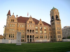
Lackawanna County Courthouse, Scranton, Pennsylvania, USA.


