Blair County
 | |
| Verwaltung | |
|---|---|
| US-Bundesstaat: | Pennsylvania |
| Verwaltungssitz: | Hollidaysburg |
| Adresse des Verwaltungssitzes: | Blair County Courthouse 423 Allegheny Street Hollidaysburg, PA 16648-2022 |
| Gründung: | 26. Februar 1846 |
| Gebildet aus: | Huntingdon County Bedford County |
| Vorwahl: | 001 814 |
| Demographie | |
| Einwohner: | 122.822 (Stand: 2020) |
| Bevölkerungsdichte: | 90,18 Einwohner/km2 |
| Geographie | |
| Fläche gesamt: | 1365 km² |
| Wasserfläche: | 3 km² |
| Karte | |
 | |
| Website: www.blairco.org | |
Blair County[1] ist ein County im Bundesstaat Pennsylvania der Vereinigten Staaten. Bei der Volkszählung im Jahr 2020 hatte das County 122.822 Einwohner und eine Bevölkerungsdichte von 90 Einwohner pro Quadratkilometer.[2] Der Verwaltungssitz (County Seat) ist Hollidaysburg.
Geschichte
Das County wurde am 26. Februar 1846 aus dem Huntingdon und Bedford County gebildet und nach John Blair benannt, einem Abgeordneten in der Pennsylvania General Assembly, der sich für den Bau von Kanälen und Eisenbahnstrecken einsetzte.[3]
Im County liegt eine National Historic Site, die Allegheny Portage Railroad National Historic Site. Zwei Orte haben den Status einer National Historic Landmark, die Horseshoe Curve und die Achterbahn Leap the Dips.[4] 30 Bauwerke und Stätten des Countys sind im National Register of Historic Places (NRHP) eingetragen (Stand 18. Juli 2018).[5]
Am 21. Dezember 2012 wurden bei einem Amoklauf vor der Juniata Valley Gospel Church auf der Juniata Valley Road im Stadtteil Geeseytown, 4 Menschen getötet und drei Polizisten verletzt.[6]
Geographie
Das County hat eine Fläche von 1365 Quadratkilometern, wovon 3 Quadratkilometer Wasserfläche sind. Beaver County grenzt im Norden an Centre County, im Osten an Huntingdon County, im Süden an Bedford County und im Westen an Cambria County.
Das County wird vom Office of Management and Budget zu statistischen Zwecken als Altoona, PA Metropolitan Statistical Area geführt.[7]
Städte und Ortschaften
Das Blair County ist unterteilt in 25 Gemeinden, davon eine City, 9 Boroughs und 15 Townships. Das Borough Tunnelhill befindet sich nur zu einem kleinen Teil im Blair County. Zu Statistikzwecken führt das U.S. Census Bureau zwei Census-designated places. Diese sind Teil eines Townships und haben keine Selbstverwaltung.

| Bevölkerungsentwicklung | |||
|---|---|---|---|
| Census | Einwohner | ± rel. | |
| 1910 | 108.858 | — | |
| 1920 | 128.334 | 17,9 % | |
| 1930 | 139.840 | 9 % | |
| 1940 | 140.358 | 0,4 % | |
| 1950 | 139.519 | −0,6 % | |
| 1960 | 137.270 | −1,6 % | |
| 1970 | 135.356 | −1,4 % | |
| 1980 | 136.621 | 0,9 % | |
| 1990 | 130.542 | −4,4 % | |
| 2000 | 129.144 | −1,1 % | |
| 2010 | 127.089 | −1,6 % | |
| 2020 | 122.822 | −3,4 % | |
| 1900–1990[8] 2000[9] | |||
City
Boroughs
|
|
1teilweise im Cambria County
Townships
|
|
Census-designated places
- Claysburg
- Tipton
Sehenswürdigkeiten
- Daniel Royer House
Einzelnachweise
- ↑ Blair County. In: Geographic Names Information System. United States Geological Survey, United States Department of the Interior, abgerufen am 22. Februar 2011 (englisch).
- ↑ U.S. Census Bureau QuickFacts: Blair County, Pennsylvania. Abgerufen am 25. August 2021 (englisch).
- ↑ Charles Curry Aiken, Joseph Nathan Kane: The American Counties: Origins of County Names, Dates of Creation, Area, and Population Data, 1950–2010. 6. Auflage. Scarecrow Press, Lanham 2013, ISBN 978-0-8108-8762-6, S. 25.
- ↑ Listing of National Historic Landmarks by State: Pennsylvania. National Park Service, abgerufen am 18. Juli 2018.
- ↑ Suchmaske Datenbank im National Register Information System. National Park Service, abgerufen am 18. Juli 2018.
- ↑ Altoona Mirror (Hrsg.): DA: 4 dead, 3 troopers hurt in shootings. [Karte], Maßstab 1:65,000. (englisch, altoonamirror.com [abgerufen am 21. Dezember 2012]).
- ↑ OMB BULLETIN NO. 20-01. Abgerufen am 25. April 2022.
- ↑ Auszug aus Census.gov. Abgerufen am 28. Februar 2011
- ↑ Archivierte Kopie ( des vom 10. Februar 2020 im Webarchiv archive.today) Info: Der Archivlink wurde automatisch eingesetzt und noch nicht geprüft. Bitte prüfe Original- und Archivlink gemäß Anleitung und entferne dann diesen Hinweis. Abgerufen am 28. Februar 2011
Weblinks
Koordinaten: 40° 28′ N, 78° 21′ W
Auf dieser Seite verwendete Medien
Map of Blair County, Pennsylvania, United States with township and municipal boundaries
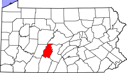
This is a locator map showing Blair County in Pennsylvania. For more information, see Commons:United States county locator maps.
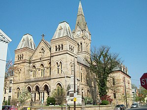
Blair County Courthouse, April 2010


