Montour County
 | |
| Verwaltung | |
|---|---|
| US-Bundesstaat: | Pennsylvania |
| Verwaltungssitz: | Danville |
| Adresse des Verwaltungssitzes: | Montour County Courthouse 29 Mill Street Danville, PA 17821 |
| Gründung: | 3. Mai 1850 |
| Gebildet aus: | Columbia County |
| Vorwahl: | 001 570 |
| Demographie | |
| Einwohner: | 18.136 (Stand: 2020) |
| Bevölkerungsdichte: | 53,5 Einwohner/km2 |
| Geographie | |
| Fläche gesamt: | 343 km² |
| Wasserfläche: | 4 km² |
| Karte | |
 | |
| Website: www.montourco.org | |
Montour County[1] ist ein County im Bundesstaat Pennsylvania der Vereinigten Staaten. Bei der Volkszählung im Jahr 2020 hatte das County 18.136 Einwohner und eine Bevölkerungsdichte von 54 Einwohner pro Quadratkilometer.[2] Der Verwaltungssitz (County Seat) ist Danville.
Geschichte
Das County wurde am 3. Mai 1850 gebildet. Die Benennung geht auf die irokesische Dolmetscherin Catherine Montour (1686–1752) zurück.[3]

Sechs Bauwerke und Stätten des Countys sind im National Register of Historic Places (NRHP) eingetragen (Stand 24. Juli 2018).[4]
Geographie
Das County hat eine Fläche von 343 Quadratkilometern, wovon 4 Quadratkilometer Wasserfläche sind.
Bevölkerungsentwicklung
| Bevölkerungsentwicklung | |||
|---|---|---|---|
| Census | Einwohner | ± rel. | |
| 1900 | 15.526 | — | |
| 1910 | 14.868 | −4,2 % | |
| 1920 | 14.080 | −5,3 % | |
| 1930 | 14.517 | 3,1 % | |
| 1940 | 15.466 | 6,5 % | |
| 1950 | 16.001 | 3,5 % | |
| 1960 | 16.730 | 4,6 % | |
| 1970 | 16.508 | −1,3 % | |
| 1980 | 16.675 | 1 % | |
| 1990 | 17.735 | 6,4 % | |
| 2000 | 18.239 | 2,8 % | |
| 2010 | 18.267 | 0,2 % | |
| 2020 | 18.136 | −0,7 % | |
| 1900–1990[5] 2000[6] | |||

Städte und Ortschaften
- Anthony Township
- Cooper Township
- Danville
- Derry Township
- Liberty Township
- Limestone Township
- Mahoning Township
- Mayberry Township
- Mechanicsville
- Valley Township
- Washingtonville
- West Hemlock Township
Weblinks
Einzelnachweise
- ↑ Montour County. In: Geographic Names Information System. United States Geological Survey, United States Department of the Interior, abgerufen am 22. Februar 2011 (englisch).
- ↑ U.S. Census Bureau QuickFacts: Montour County, Pennsylvania. Abgerufen am 28. August 2021 (englisch).
- ↑ Charles Curry Aiken, Joseph Nathan Kane: The American Counties: Origins of County Names, Dates of Creation, Area, and Population Data, 1950–2010. 6. Auflage. Scarecrow Press, Lanham 2013, ISBN 978-0-8108-8762-6, S. 214.
- ↑ Suchmaske Datenbank im National Register Information System. National Park Service, abgerufen am 24. Juli 2018.
- ↑ Auszug aus Census.gov. Abgerufen am 28. Februar 2011
- ↑ Auszug aus factfinder.census.gov (Seite nicht mehr abrufbar, festgestellt im Dezember 2022. Suche in Webarchiven) Info: Der Link wurde automatisch als defekt markiert. Bitte prüfe den Link gemäß Anleitung und entferne dann diesen Hinweis. Abgerufen am 28. Februar 2011
Koordinaten: 41° 2′ N, 76° 40′ W
Auf dieser Seite verwendete Medien
Autor/Urheber: unknown, Lizenz: CC BY-SA 3.0
Autor/Urheber: Smallbones, Lizenz: CC0
Gen. William Montgomery House on the NRHP since August 9, 1979. At 1 and 3 Bloom Street, Danville, Montour County, Pennsylvania
Autor/Urheber: Smallbones, Lizenz: CC0
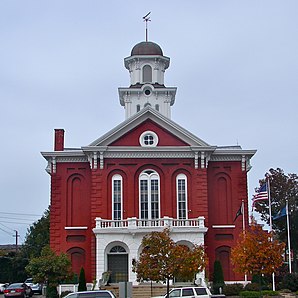
Montour County Courthouse, Danville, Pennsylvania. In the square defined by Market, Mill, and Roonney Streets and Friendship alley. Coords 40.960245,-76.619253
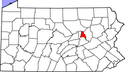
This is a locator map showing Montour County in Pennsylvania. For more information, see Commons:United States county locator maps.


