Lycoming County
 | |
| Verwaltung | |
|---|---|
| US-Bundesstaat: | Pennsylvania |
| Verwaltungssitz: | Williamsport |
| Gründung: | 13. April 1795 |
| Gebildet aus: | Northumberland County |
| Vorwahl: | 001 570 |
| Demographie | |
| Einwohner: | 114.188 (Stand: 2020) |
| Bevölkerungsdichte: | 35,71 Einwohner/km2 |
| Geographie | |
| Fläche gesamt: | 3221 km² |
| Wasserfläche: | 23 km² |
| Karte | |
 | |
| Website: www.lyco.org | |
Lycoming County[1] ist ein County im US-Bundesstaat Pennsylvania der Vereinigten Staaten. Bei der Volkszählung im Jahr 2020 hatte der County 114.188 Einwohner und eine Bevölkerungsdichte von 36 Einwohner pro Quadratkilometer.[2] Der Verwaltungssitz (County Seat) ist Williamsport.
Geschichte
Spuren altamerikanischer Besiedlung finden sich im Canfield Island Site.
Das County wurde am 13. April 1795 gebildet und nach dem Lycoming Creek benannt, einem Zufluss des Susquehanna River.[3]
19 Bauwerke und Stätten des Countys sind im National Register of Historic Places (NRHP) eingetragen (Stand 23. Juli 2018).[4]
Geographie
Das County hat eine Fläche von 3221 Quadratkilometern, davon sind 23 Quadratkilometer Wasserfläche. Es wird vom Office of Management and Budget zu statistischen Zwecken als Williamsport, PA Metropolitan Statistical Area geführt.[5]
Städte und Ortschaften

| Bevölkerungsentwicklung | |||
|---|---|---|---|
| Census | Einwohner | ± rel. | |
| 1800 | 5.414 | — | |
| 1810 | 11.006 | 103,3 % | |
| 1820 | 13.517 | 22,8 % | |
| 1830 | 17.636 | 30,5 % | |
| 1840 | 22.649 | 28,4 % | |
| 1850 | 26.257 | 15,9 % | |
| 1860 | 37.399 | 42,4 % | |
| 1870 | 47.626 | 27,3 % | |
| 1880 | 57.486 | 20,7 % | |
| 1890 | 70.579 | 22,8 % | |
| 1900 | 75.663 | 7,2 % | |
| 1910 | 80.813 | 6,8 % | |
| 1920 | 83.100 | 2,8 % | |
| 1930 | 93.421 | 12,4 % | |
| 1940 | 93.633 | 0,2 % | |
| 1950 | 101.249 | 8,1 % | |
| 1960 | 109.367 | 8 % | |
| 1970 | 113.296 | 3,6 % | |
| 1980 | 118.416 | 4,5 % | |
| 1990 | 118.710 | 0,2 % | |
| 2000 | 120.044 | 1,1 % | |
| 2010 | 116.111 | −3,3 % | |
| 2020 | 114.188 | −1,7 % | |
| Vor 1900[6] | |||
|
|
|
Sehenswürdigkeiten
- Buttonwood Covered Bridge in Jackson Township
Einzelnachweise
- ↑ Lycoming County. In: Geographic Names Information System. United States Geological Survey, United States Department of the Interior, abgerufen am 22. Februar 2011 (englisch).
- ↑ U.S. Census Bureau QuickFacts: Lycoming County, Pennsylvania. Abgerufen am 28. August 2021 (englisch).
- ↑ Charles Curry Aiken, Joseph Nathan Kane: The American Counties: Origins of County Names, Dates of Creation, Area, and Population Data, 1950–2010. 6. Auflage. Scarecrow Press, Lanham 2013, ISBN 978-0-8108-8762-6, S. 187.
- ↑ Suchmaske Datenbank im National Register Information System. National Park Service, abgerufen am 23. Juli 2018.
- ↑ OMB BULLETIN NO. 20-01. Abgerufen am 25. April 2022.
- ↑ U.S. Census Bureau _ Census of Population and Housing. Abgerufen am 28. Februar 2011
- ↑ Auszug aus Census.gov. Abgerufen am 28. Februar 2011
- ↑ Auszug aus factfinder.census.gov (Seite nicht mehr abrufbar, festgestellt im März 2022. Suche in Webarchiven) Info: Der Link wurde automatisch als defekt markiert. Bitte prüfe den Link gemäß Anleitung und entferne dann diesen Hinweis. Abgerufen am 28. Februar 2011
Weblinks
Koordinaten: 41° 21′ N, 77° 4′ W
Auf dieser Seite verwendete Medien
Autor/Urheber: User:Ruhrfisch, Lizenz: CC BY-SA 3.0
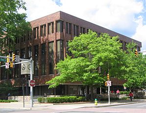
Lycoming County Courthouse, Williamsport, Pennsylvania USA
This is a locator map showing Lycoming County in Pennsylvania. For more information, see Commons:United States county locator maps.
Autor/Urheber: Ruhrfisch, Lizenz: CC BY-SA 3.0
Map of Lycoming County with township and municipal bondaries is taken from US Census website [1] and modified by User:Ruhrfisch in August 2005. My modifications licensed under the GNU Free Documentation License.


