Butler County (Pennsylvania)
 | |
| Verwaltung | |
|---|---|
| US-Bundesstaat: | Pennsylvania |
| Verwaltungssitz: | Butler |
| Adresse des Verwaltungssitzes: | 124 W. Diamond St. Butler, PA 16001 |
| Gründung: | 12. März 1800 |
| Gebildet aus: | Allegheny County |
| Vorwahl: | 001 724 |
| Demographie | |
| Einwohner: | 193.763 (Stand: 2020) |
| Bevölkerungsdichte: | 94,89 Einwohner/km2 |
| Geographie | |
| Fläche gesamt: | 2058 km² |
| Wasserfläche: | 16 km² |
| Karte | |
 | |
| Website: www.co.butler.pa.us | |
Butler County[1] ist ein County im Bundesstaat Pennsylvania der Vereinigten Staaten. Bei der Volkszählung im Jahr 2020 hatte das County 193.763[2] Einwohner und eine Bevölkerungsdichte von 95 Einwohner pro Quadratkilometer. Der Verwaltungssitz (County Seat) ist Butler.
Geschichte
Das County wurde am 12. März 1800 gegründet und ist nach dem General aus dem Amerikanischen Unabhängigkeitskrieg, Richard Butler, benannt.[3]
Ein Ort im County hat den Status einer National Historic Landmark, der Harmony Historic District.[4] Elf Bauwerke und Stätten des Countys sind im National Register of Historic Places (NRHP) eingetragen (Stand 20. Juli 2018).[5]
Geographie
Das County hat eine Fläche von 2058 Quadratkilometern, wovon 16 Quadratkilometer Wasserfläche sind.
Bevölkerungsentwicklung
| Bevölkerungsentwicklung | |||
|---|---|---|---|
| Census | Einwohner | ± rel. | |
| 1900 | 56.962 | — | |
| 1910 | 72.689 | 27,6 % | |
| 1920 | 77.270 | 6,3 % | |
| 1930 | 80.480 | 4,2 % | |
| 1940 | 87.590 | 8,8 % | |
| 1950 | 97.320 | 11,1 % | |
| 1960 | 114.639 | 17,8 % | |
| 1970 | 127.941 | 11,6 % | |
| 1980 | 147.912 | 15,6 % | |
| 1990 | 152.013 | 2,8 % | |
| 2000 | 174.083 | 14,5 % | |
| 2010 | 183.862 | 5,6 % | |
| 2020 | 193.763 | 5,4 % | |
| 1900–1990[6] 2000[7] | |||
Städte und Ortschaften

|
|
|
Einzelnachweise
- ↑ Butler County. In: Geographic Names Information System. United States Geological Survey, United States Department of the Interior, abgerufen am 22. Februar 2011 (englisch).
- ↑ Explore Census Data Total Population in Butler County, Pennsylvania. Abgerufen am 24. März 2023.
- ↑ Charles Curry Aiken, Joseph Nathan Kane: The American Counties: Origins of County Names, Dates of Creation, Area, and Population Data, 1950–2010. 6. Auflage. Scarecrow Press, Lanham 2013, ISBN 978-0-8108-8762-6, S. 38.
- ↑ Listing of National Historic Landmarks by State: Pennsylvania. National Park Service, abgerufen am 20. Juli 2018.
- ↑ Suchmaske Datenbank im National Register Information System. National Park Service, abgerufen am 20. Juli 2018.
- ↑ Auszug aus Census.gov. Abgerufen am 28. Februar 2011
- ↑ Auszug aus factfinder.census.gov (Seite nicht mehr abrufbar, festgestellt im Oktober 2022. Suche in Webarchiven) Info: Der Link wurde automatisch als defekt markiert. Bitte prüfe den Link gemäß Anleitung und entferne dann diesen Hinweis. Abgerufen am 28. Februar 2011
Weblinks
Koordinaten: 40° 55′ N, 79° 55′ W
Auf dieser Seite verwendete Medien
This is a locator map showing Butler County in Pennsylvania. For more information, see Commons:United States county locator maps.
Map of Butler County, Pennsylvania, United States with township and municipal boundaries is taken from US Census website [1] and modified by User:Ruhrfisch in April 2006. My modifications licensed under the GNU Free Documentation License.
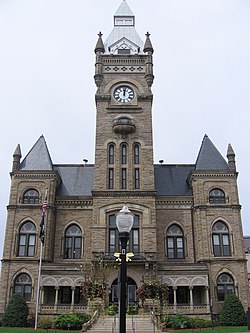
Source: US Census website [2]Front of the Butler County Courthouse, located at the intersection of South Main and West Diamond Streets in downtown Butler, Pennsylvania, United States. Built in 1885, the courthouse is listed on the National Register of Historic Places, and it is located within the bounds of the Register-listed Butler Historic District.


