Northumberland County (Pennsylvania)
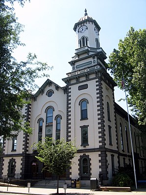
 Northumberland County Courthouse | |
| Verwaltung | |
|---|---|
| US-Bundesstaat: | Pennsylvania |
| Verwaltungssitz: | Sunbury |
| Adresse des Verwaltungssitzes: | Northumberland County Commissioners’ Office Sunbury, PA 17801 |
| Gründung: | 21. März 1772 |
| Gebildet aus: | Lancaster County Berks County Bedford County Cumberland County Northampton County |
| Vorwahl: | 001 570 |
| Demographie | |
| Einwohner: | 91.647 (Stand: 2020) |
| Bevölkerungsdichte: | 76,95 Einwohner/km2 |
| Geographie | |
| Fläche gesamt: | 1236 km² |
| Wasserfläche: | 45 km² |
| Karte | |
 | |
| Website: www.northumberlandco.org | |
Northumberland County[1] ist ein County im Bundesstaat Pennsylvania der Vereinigten Staaten. Bei der Volkszählung im Jahr 2020 hatte der County 91.647 Einwohner und eine Bevölkerungsdichte von 77 Einwohner pro Quadratkilometer.[2] Der Verwaltungssitz (County Seat) ist Sunbury.
Geographie
Das County hat eine Fläche von 1236 Quadratkilometern, davon sind 45 Quadratkilometer (4,0 %) Wasserfläche. Es fällt in das Einzugsgebiet des Susquehanna River. Zu den größeren Fließgewässern im County gehören (von Norden nach Süden) West Branch Susquehanna River, Chillisquaque Creek, Shamokin Creek und Mahanoy Creek.
Die höchsten Erhebungen im County sind der 433 m hohe Mahanoy Mountain und der Little Mountain, der sich im County auf 402 m erhebt.
Die Hauptstraßen innerhalb des Countys sind:
 Interstate 80
 Interstate 180
 U.S. Highway 11
 U.S. Highway 15
 Pennsylvania Route 44
 Pennsylvania Route 54
 Pennsylvania Route 61
 Pennsylvania Route 147
Geschichte
Das County wurde am 22. März 1772 gebildet und nach der englischen Grafschaft Northumberland benannt.[3]

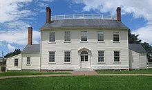
Ein Ort im County hat den Status einer National Historic Landmark, das Joseph Priestley House.[4] 28 Bauwerke und Stätten des Countys sind im National Register of Historic Places (NRHP) eingetragen (Stand 24. Juli 2018).[5]
Demographie
| Bevölkerungsentwicklung | |||
|---|---|---|---|
| Census | Einwohner | ± rel. | |
| 1790 | 17.147 | — | |
| 1800 | 27.797 | 62,1 % | |
| 1810 | 36.327 | 30,7 % | |
| 1820 | 15.424 | −57,5 % | |
| 1830 | 18.133 | 17,6 % | |
| 1840 | 20.027 | 10,4 % | |
| 1850 | 23.272 | 16,2 % | |
| 1860 | 28.922 | 24,3 % | |
| 1870 | 41.444 | 43,3 % | |
| 1880 | 53.123 | 28,2 % | |
| 1890 | 74.698 | 40,6 % | |
| 1900 | 90.911 | 21,7 % | |
| 1910 | 111.420 | 22,6 % | |
| 1920 | 122.079 | 9,6 % | |
| 1930 | 128.504 | 5,3 % | |
| 1940 | 126.887 | −1,3 % | |
| 1950 | 117.115 | −7,7 % | |
| 1960 | 104.138 | −11,1 % | |
| 1970 | 99.190 | −4,8 % | |
| 1980 | 100.381 | 1,2 % | |
| 1990 | 96.771 | −3,6 % | |
| 2000 | 94.556 | −2,3 % | |
| 2010 | 94.528 | −0 % | |
| 2020 | 91.647 | −3 % | |
| 1900–1990[6] 2000[7] | |||
Zum Zeitpunkt des United States Census 2000 bewohnten das Northumberland County 94.556 Personen. Die Bevölkerungsdichte betrug 79 Personen pro km². Es gab 43.164 Wohneinheiten, durchschnittlich 36 pro km². Die Bevölkerung des Northumberland Countys bestand zu 97,09 % aus Weißen, 1,52 % Schwarzen oder African American, 0,10 % Native American, 0,22 % Asian, 0,02 % Pacific Islander, 0,47 % gaben an, anderen Rassen anzugehören und 0,58 % nannten zwei oder mehr Rassen. 1,10 % der Bevölkerung erklärten, Hispanos oder Latinos jeglicher Rasse zu sein.
Die Bewohner des Northumberland Countys verteilten sich auf 38.835 Haushalte, von denen in 27,3 % Kinder unter 18 Jahren lebten. 52,4 % der Haushalte stellten Verheiratete, 9,6 % hatten einen weiblichen Haushaltsvorstand ohne Ehemann und 34,1 % bildeten keine Familien. 30,2 % der Haushalte bestanden aus Einzelpersonen und in 15,5 % aller Haushalte lebte jemand im Alter von 65 Jahren oder mehr alleine. Die durchschnittliche Haushaltsgröße betrug 2,34 und die durchschnittliche Familiengröße 2,89 Personen.
Die Bevölkerung verteilte sich auf 21,9 % Minderjährige, 7,0 % 18–24-Jährige, 27,7 % 25–44-Jährige, 24,4 % 45–64-Jährige und 19,0 % im Alter von 65 Jahren oder mehr. Der Median des Alters betrug 41 Jahre. Auf jeweils 100 Frauen entfielen 96,3 Männer. Bei den über 18-Jährigen entfielen auf 100 Frauen 92,8 Männer.
Bei der Volkszählung 2000 hatten 32,5 % deutsche, 12,9 % polnische, 9,9 % amerikanische, 8,2 % italienische, 8,1 % irische und 5,8 % niederländische Vorfahren. 95,8 % der Bevölkerung sprachen Englisch und 1,5 % Spanisch als ihre erste gesprochene Sprache.
Im Jahr 1990 kamen im Northumberland County 1167 Kinder zur Welt. Im Jahr 2000 ging die Geburtenzahl auf 919 Geburten zurück. 2011 kamen 961 Babys lebend zu Welt.[8]

Townships
|
|
|
Citys und Boroughs
|
|
|
Census-designated places
|
|
Micropolitan Statistical Area

Das Office of Management and Budget[9] hat das Northumberland County als Sunbury, PA Micropolitan Statistical Area (µSA) ausgewiesen. Aufgrund der beim United States Census 2010 ermittelten Einwohnerzahlen[10] rangiert die Micropolitan Statistical Area mit 94.528 Einwohnern als nach Einwohnern zweitgrößte im Bundesstaat Pennsylvania und an 37. Stelle in den Vereinigten Staaten. Das Northumberland County ist außerdem Bestandteil der Bloomsburg-Berwick-Sunbury, PA Combined Statistical Area (CSA), zu der außer dem Northumberland County auch die Gebiete von Columbia County, Montour County, Snyder County und Union County gehören. Diese Combined Statistical Area war 2010 mit 264.739 Einwohnern die achtgrößte im Bundesstaat und landesweit an 115. Stelle.
Filme
Die Hauptfiguren des Films Niemals Selten Manchmal Immer kommt aus dem Northumberland County.
Weblinks
Einzelnachweise
- ↑ Northumberland County. In: Geographic Names Information System. United States Geological Survey, United States Department of the Interior (englisch).. Abgerufen am 22. Februar 2011
- ↑ U.S. Census Bureau QuickFacts: Northumberland County, Pennsylvania. Abgerufen am 28. August 2021 (englisch).
- ↑ Charles Curry Aiken, Joseph Nathan Kane: The American Counties: Origins of County Names, Dates of Creation, Area, and Population Data, 1950–2010. 6. Auflage. Scarecrow Press, Lanham 2013, ISBN 978-0-8108-8762-6, S. 225.
- ↑ Listing of National Historic Landmarks by State: Pennsylvania. National Park Service, abgerufen am 23. Juli 2018.
- ↑ Suchmaske Datenbank im National Register Information System. National Park Service, abgerufen am 24. Juli 2018.
- ↑ Auszug aus Census.gov. Abgerufen am 28. Februar 2011
- ↑ Auszug aus factfinder.census.gov (Seite nicht mehr abrufbar, festgestellt im Dezember 2022. Suche in Webarchiven.) Info: Der Link wurde automatisch als defekt markiert. Bitte prüfe den Link gemäß Anleitung und entferne dann diesen Hinweis. Abgerufen am 28. Februar 2011
- ↑ Pennsylvania Department of Health, Birth Age County Reports 1990 and 2011, 2011
- ↑ Office of Management and Budget. In: The White House. Abgerufen am 17. Oktober 2016 (englisch).
- ↑ Center for New Media and Promotions(C2PO): 2010 Census. In: census.gov. Abgerufen am 17. Oktober 2016 (englisch).
Koordinaten: 40° 51′ N, 76° 43′ W
Auf dieser Seite verwendete Medien
600 mm by 600 mm (24 in by 24 in) Interstate shield, made to the specifications of the 2004 edition of Standard Highway Signs (sign M1-1). Uses the Roadgeek 2005 fonts. (United States law does not permit the copyrighting of typeface designs, and the fonts are meant to be copies of a U.S. Government-produced work anyway.) Colors are from [1] (Pantone Red 187 and Blue 294), converted to RGB by [2]. The outside border has a width of 1 (1 mm) and a color of black so it shows up; in reality, signs have no outside border.
750 mm by 600 mm (30 in by 24 in) Pennsylvania shield, made to the specifications of the Manual on Uniform Traffic Control Devices (MUTCD), 2003 Edition (sign M1-5). Uses the Roadgeek 2005 fonts. (United States law does not permit the copyrighting of typeface designs, and the fonts are meant to be copies of a U.S. Government-produced work anyway.)
Autor/Urheber: Georgie lennon8705, Lizenz: CC BY-SA 3.0
Bloomsburg Berwick Sunbury CSA updated
Autor/Urheber: User:Ruhrfisch, Lizenz: CC BY-SA 3.0
Dieses Panoramabild wurde mit Autostitch erstellt (Motiv kann durch das Stiching verzerrt sein).
600 mm by 600 mm (24 in by 24 in) Pennsylvania shield, made to the specifications of the Manual on Uniform Traffic Control Devices (MUTCD), 2003 Edition (sign M1-5). Uses the Roadgeek 2005 fonts. (United States law does not permit the copyrighting of typeface designs, and the fonts are meant to be copies of a U.S. Government-produced work anyway.)
Autor/Urheber: Publichall, Lizenz: CC BY-SA 3.0
The Northumberland County Courthouse in Sunbury, Pennsylvania was built by D.S. Rissell in 1865. It was listed on the National Register of Historic Places in 1974.
600 mm by 600 mm (24 in by 24 in) Pennsylvania shield, made to the specifications of the Manual on Uniform Traffic Control Devices (MUTCD), 2003 Edition (sign M1-5). Uses the Roadgeek 2005
fonts. (United States law does not permit the copyrighting of typeface designs, and the fonts are meant to be copies of a U.S. Government-produced work anyway.)600 mm × 600 mm (24 in × 24 in) U.S. Highway shield, made to the specifications of the 2004 edition of Standard Highway Signs. (Note that there is a missing "J" label on the left side of the diagram.) Uses the Roadgeek 2005 fonts. (United States law does not permit the copyrighting of typeface designs, and the fonts are meant to be copies of a U.S. Government-produced work anyway.)
600 mm by 600 mm (24 in by 24 in) Pennsylvania shield, made to the specifications of the Manual on Uniform Traffic Control Devices (MUTCD), 2003 Edition (sign M1-5). Uses the Roadgeek 2005 fonts. (United States law does not permit the copyrighting of typeface designs, and the fonts are meant to be copies of a U.S. Government-produced work anyway.)
This is a locator map showing Northumberland County in Pennsylvania. For more information, see Commons:United States county locator maps.
Autor/Urheber: unknown, Lizenz: CC BY-SA 3.0
600 mm × 600 mm (24 in × 24 in) U.S. Highway shield, made to the specifications of the 2004 edition of Standard Highway Signs. (Note that there is a missing "J" label on the left side of the diagram.) Uses the Roadgeek 2005 fonts. (United States law does not permit the copyrighting of typeface designs, and the fonts are meant to be copies of a U.S. Government-produced work anyway.)


