Municipio Cocotitlán
| Cocotitlán | ||
|---|---|---|
 | ||
| Symbole | ||
| ||
| Basisdaten | ||
| Staat | Mexiko | |
| Bundesstaat | México | |
| Sitz | Cocotitlán | |
| Fläche | 15 km² | |
| Einwohner | 12.142 (2010) | |
| Dichte | 809,3 Einwohner pro km² | |
| Gründung | 1868 | |
| Webauftritt | cocotitlan.gob.mx | |
| INEGI-Nr. | 15022 | |
| Politik | ||
| Presidente municipal | Miguel Florín González | |
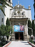
| Templo la Purísima Concepción in Cocotitlán | ||
Koordinaten: 19° 13′ 52″ N, 98° 51′ 50″ W
Cocotitlán ist ein Municipio im mexikanischen Bundesstaat México. Es gehört zur Zona Metropolitana del Valle de México, der Metropolregion um Mexiko-Stadt. Die Gemeinde hatte im Jahr 2010 12.142 Einwohner, ihre Fläche beträgt 15 km².
Verwaltungssitz und größter Ort des Municipios ist das gleichnamige Cocotitlán, die nächstgrößeren Orte sind San Andrés Metla und Ejido Atoyac.
Geographie
Das Municipio Cocotitlán liegt im Osten des Bundesstaats México. Es grenzt an die Municipios Chalco, Tlalmanalco und Temamatla.
Weblinks
- INEGI: Datos Geográficos: Municipio Cocotitlán (spanisch; PDF)
- Enciclopedia de los Municipios y Delegaciones de México: Municipio Cocotitlán (spanisch)
Auf dieser Seite verwendete Medien
Coat of arms of Mexico State
Autor/Urheber: Patricia Alzuarte Díaz, Lizenz: CC BY-SA 3.0
Dieses Bild zeigt das Denkmal in Mexiko mit der Nummer
Autor/Urheber: Sarumo74, Lizenz: CC BY 3.0
Logo based on the shield of the municipality of Cocotitlan belonging to the State of Mexico, based on the one shown in the official website of the municipality and the Municipal Bando Police and Good Government www.edomex.gob.mx/legistelfon/doc/pdf/bdo/bdo029.pdf


