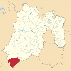
Municipio Tlatlaya
| Tlatlaya | ||
|---|---|---|
 | ||
| Symbole | ||
| ||
| Basisdaten | ||
| Staat | Mexiko | |
| Bundesstaat | México | |
| Sitz | Tlatlaya | |
| Fläche | 790,1 km² | |
| Einwohner | 32.997 (2010) | |
| Dichte | 41,8 Einwohner pro km² | |
| Gründung | 1849 | |
| INEGI-Nr. | 15105 | |
| Politik | ||
| Presidente municipal | Ariel Mora Abarca | |
Koordinaten: 18° 36′ N, 100° 12′ W
Tlatlaya ist ein Municipio im mexikanischen Bundesstaat México. Das Municipio hatte beim Zensus 2010 32997 Einwohner, die Fläche beläuft sich auf 798,92 km². Der Sitz der Gemeinde ist das gleichnamige Tlatlaya, die größten der 165 Orte des Municipios sind hingegen San Pedro Limón und Santa Ana Zicatecoyan.
Geographie
Tlatlaya liegt im äußersten Südwesten des Bundesstaates México, etwa 120 km südwestlich von Toluca de Lerdo auf einer Höhe von 300 m bis 2400 m.
Das Municipio Tlatlaya grenzt ans Municipio Amatepec, sowie an den Bundesstaat Guerrero.
Weblinks
- Enciclopedia de los Municipios y Delegaciones de México: Municipio Tlatlaya (spanisch)
- INEGI: Datos Geográficos: Municipio Tlatlaya (spanisch; PDF)
Auf dieser Seite verwendete Medien
Coat of arms of Mexico State
Mapa de localización del municipio de Tlatlaya en el Estado de México, México.
Autor/Urheber: Sarumo74, Lizenz: CC BY 3.0
Logo based on the shield of the municipality of Tlatlaya belonging to the State of Mexico, based on the one shown in the official website of the municipality and the Municipal Bando Police and Good Government www.edomex.gob.mx/legistelfon/doc/pdf/bdo/bdo107.pdf art. 8


