Municipio Ixtlahuaca
| Ixtlahuaca | ||
|---|---|---|
 | ||
| Symbole | ||
| ||
| Basisdaten | ||
| Staat | Mexiko | |
| Bundesstaat | México | |
| Sitz | Ixtlahuaca de Rayón | |
| Fläche | 337,2 km² | |
| Einwohner | 141.482 (2010) | |
| Dichte | 419,6 Einwohner pro km² | |
| Gründung | 1826 | |
| Webauftritt | www.ixtlahuaca.gob.mx/ | |
| INEGI-Nr. | 15042 | |
| Politik | ||
| Presidente municipal | Ángel Alberto Rebollo Montes de Oca | |
| Franz-von-Assisi-Kirche in Ixtlahuaca | ||
Koordinaten: 19° 34′ N, 99° 46′ W
Ixtlahuaca ist ein Municipio im mexikanischen Bundesstaat México. Cabecera des Municipios ist Ixtlahuaca de Rayón. Das Municipio hatte im Jahr 2010 141.482 Einwohner, seine Fläche beträgt 337,2 km².
Geographie
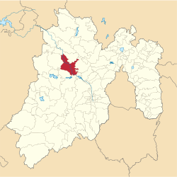
Ixtlahuaca liegt im Nordwesten des Bundesstaates México, 35 km nordwestlich von Toluca de Lerdo. Ein überwiegender Teil des Municipios wird landwirtschaftlich genutzt.
Das Municipio Ixtlahuaca grenzt an die Municipios San Felipe del Progreso, Jocotitlán, Jiquipilco, Temoaya und Almoloya de Juárez.
Orte
Das Municipio umfasst 63 Orte, von denen sechs mehr als 5.000 und weitere 24 mehr als 1.500 Einwohner aufweisen. Größter Ort des Municipios ist San Bartolo del Llano, vor San Pedro los Baños, Santo Domingo de Guzmán, Emiliano Zapata, La Concepción los Baños und Ixtlahuaca de Rayón.
Weblinks
- INEGI: Datos Geográficos: Municipio Ixtlahuaca (spanisch; PDF)
- Enciclopedia de los Municipios y Delegaciones de México: Municipio Ixtlahuaca (spanisch)
Auf dieser Seite verwendete Medien
Coat of arms of Mexico State
Autor/Urheber: Jolivaresb, Lizenz: CC BY-SA 3.0
Dieses Bild zeigt das Denkmal in Mexiko mit der Nummer
Autor/Urheber: Sarumo74, Lizenz: CC BY 3.0
Logo based on the shield of the municipality of Ixtlahuaca belonging to the State of Mexico, based on the one shown in the official website of the municipality and the Municipal Bando Police and Good Governmen. www.ixtlahuaca.gob.mx/index.php?option=com_content&view=article&id=48&Itemid=59 and www.edomex.gob.mx/legistelfon/doc/pdf/bdo/bdo044.pdf art 7.II, with the use of the shield by Keepscases called Coat of arms of Mexico (black linear). svg
Mapa de localización del municipio de Ixtlahuaca en el Estado de México, México.


