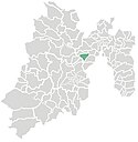
Municipio Jilotzingo
| Jilotzingo | ||
|---|---|---|
 | ||
| Symbole | ||
| ||
| Basisdaten | ||
| Staat | Mexiko | |
| Bundesstaat | México | |
| Sitz | Santa Ana Jilotzingo | |
| Fläche | 119,2 km² | |
| Einwohner | 17.970 (2010) | |
| Dichte | 150,7 Einwohner pro km² | |
| Gründung | 1868 | |
| Webauftritt | www.jilotzingo.gob.mx/h-ayuntamiento | |
| INEGI-Nr. | 15046 | |
| Politik | ||
| Presidente municipal | Reynaldo Torres González | |
Koordinaten: 19° 31′ N, 99° 25′ W

Jilotzingo ist ein Municipio im mexikanischen Bundesstaat México. Es gehört zur Zona Metropolitana del Valle de México, der Metropolregion um Mexiko-Stadt. Die Gemeinde hatte im Jahr 2010 17.970 Einwohner, ihre Fläche beträgt 119,2 km².
Verwaltungssitz ist Santa Ana Jilotzingo, die größten Orte des Municipios sind hingegen San Luis Ayucan und Santa María Mazatla.
Geographie
Jilotzingo liegt etwa 20 km westlich von Mexiko-Stadt sowie etwa 40 km nordöstlich von Toluca de Lerdo.
Das Municipio grenzt an die Municipios Isidro Fabela, Atizapán de Zaragoza, Naucalpan de Juárez, Xonacatlán und Otzolotepec.
Weblinks
- INEGI: Datos Geográficos: Municipio Jilotzingo (spanisch; PDF)
- Enciclopedia de los Municipios y Delegaciones de México: Municipio Jilotzingo (spanisch)
Auf dieser Seite verwendete Medien
Coat of arms of Mexico State
Autor/Urheber: Sarumo74, Lizenz: CC BY 3.0
Logo based on the shield of the municipality of Jilotzingo belonging to the State of Mexico, based on the one shown in the official website of the municipality. www.inafed.gob.mx/work/templates/enciclo/mexico/mpios/15046a.htm


