Municipio Ayapango
| Ayapango | ||
|---|---|---|
 | ||
| Symbole | ||
| ||
| Basisdaten | ||
| Staat | Mexiko | |
| Bundesstaat | México | |
| Sitz | Ayapango de Gabriel Ramos Millán | |
| Fläche | 36,6 km² | |
| Einwohner | 8864 (2010) | |
| Dichte | 242,5 Einwohner pro km² | |
| Gründung | 1868 | |
| Webauftritt | www.ayapango.gob.mx/ | |
| INEGI-Nr. | 15017 | |
| Politik | ||
| Presidente municipal | Pedro Alfonso Sánchez Solares | |
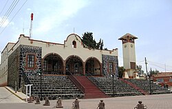
| Municipalpalast von Ayapango | ||
Koordinaten: 19° 7′ 35″ N, 98° 48′ 10″ W
Ayapango ist ein Municipio im mexikanischen Bundesstaat México. Es gehört zur Zona Metropolitana del Valle de México, der Metropolregion um Mexiko-Stadt. Der Sitz der Gemeinde und deren größter Ort ist Ayapango de Gabriel Ramos Millán. Die Gemeinde hatte im Jahr 2010 8.864 Einwohner, ihre Fläche beträgt 36,6 km².
Geographie
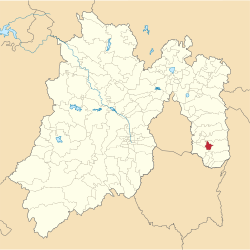
Acolman liegt im Südosten des Bundesstaates México.
Das Municipio grenzt an die Municipios Tenango del Aire, Tlalmanalco, Amecameca und Juchitepec.
Weblinks
- Enciclopedia de los Municipios y Delegaciones de México: Municipio Ayapango (spanisch)
- INEGI: Datos Geográficos: Municipio Ayapango (spanisch; PDF)
Auf dieser Seite verwendete Medien
Coat of arms of Mexico State
Autor/Urheber: Sarumo74, Lizenz: CC BY 3.0
Logo based on the shield of the municipality of Ayapangp de Gabriel Ramos Millan belonging to the State of Mexico, based on the one shown in the official website of the municipality. www.edomex.gob.mx/legistelfon/doc/pdf/bdo/bdo017.pdf
Hidalgo Street entering the town of Ayapango, Mexico State, Mexico
Mapa de localización del municipio de Ayapango en el Estado de México, México.
The Municipal Palace (government building) of Ayapango, Mexico State, Mexico


