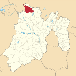
Municipio Aculco
| Aculco | ||
|---|---|---|
 | ||
| Symbole | ||
| ||
| Basisdaten | ||
| Staat | Mexiko | |
| Bundesstaat | México | |
| Sitz | Aculco de Espinosa | |
| Fläche | 455,1 km² | |
| Einwohner | 44.823 (2010) | |
| Dichte | 98,5 Einwohner pro km² | |
| Gründung | 1825 | |
| Webauftritt | www.aculco.gob.mx/ | |
| INEGI-Nr. | 15003 | |
| Politik | ||
| Presidente municipal | Salvador del Rio Martínez | |
| Capilla de El Señor del Pasito | ||
Koordinaten: 20° 6′ N, 99° 50′ W
Aculco ist ein Municipio im mexikanischen Bundesstaat México. Der Sitz der Gemeinde ist Aculco de Espinosa, einwohnerstärkster Ort hingegen San Lucas Totolmaloya vor San Jerónimo Barrio und Gunyo Poniente. Die Gemeinde hatte im Jahr 2010 44.823 Einwohner, ihre Fläche beträgt 455,1 km².
Geographie
Aculco liegt im Norden des Bundesstaates México, etwa auf halber Strecke von Mexiko-Stadt nach Santiago de Querétaro.
Das Municipio grenzt an die Municipios Jilotepec, Polotitlán, Acambay und Timilpan sowie an San Juan del Río und Amealco de Bonfil im Nachbarbundesstaat Querétaro.
Weblinks
- INEGI: Datos Geográficos: Municipio Aculco (spanisch; PDF)
- Enciclopedia de los Municipios y Delegaciones de México: Municipio Aculco (spanisch)
Auf dieser Seite verwendete Medien
Coat of arms of Mexico State
Mapa de localización del municipio de Aculco en el Estado de México, México.
Autor/Urheber: Adrianacual, Lizenz: CC BY-SA 3.0
Dieses Bild zeigt das Denkmal in Mexiko mit der Nummer
Autor/Urheber: Sarumo74, Lizenz: CC BY 3.0
Logo based on the shield of the municipality of Aculco belonging to the State of Mexico, based on the one shown in the official website of the municipality and the Municipal Bando Police and Good Government www.edomex.gob.mx/legistelfon/doc/pdf/bdo/bdo071.pdf Art. 11 and 12; and www.inafed.gob.mx/work/templates/enciclo/mexico/mpios/15069a.htm


