Wylie (Texas)
| Wylie | |
|---|---|
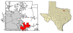
Lage in Texas | |
| Basisdaten | |
| Staat: | Vereinigte Staaten |
| Bundesstaat: | Texas |
| Countys: | Collin County Dallas County Rockwall County |
| Koordinaten: | 33° 1′ N, 96° 32′ W |
| Zeitzone: | Central (UTC−6/−5) |
| Einwohner: | 57.526 (Stand: 2020) |
| Haushalte: | 15.730 (Stand: 2020) |
| Fläche: | 86,3 km² (ca. 33 mi²) davon 50,2 km² (ca. 19 mi²) Land |
| Bevölkerungsdichte: | 1.146 Einwohner je km² |
| Höhe: | 170 m |
| Postleitzahl: | 75098 |
| Vorwahl: | +1 972 |
| FIPS: | 48-80356 |
| GNIS-ID: | 1350621 |
| Website: | www.wylietexas.gov |
| Bürgermeister: | Matthew Porter[1] |
Wylie ist eine Kleinstadt im Collin County im US-Bundesstaat Texas. Das U.S. Census Bureau hat bei der Volkszählung 2020 eine Einwohnerzahl von 57.526[2] ermittelt.
Geographie
Wylie gehört zum Großraum Dallas-Fort Worth und liegt 23,3 Meilen nordöstlich von Dallas, es erstreckt sich über 86,2 km².
| Bevölkerungswachstum | |||
|---|---|---|---|
| Census | Einwohner | ± rel. | |
| 1890 | 239 | — | |
| 1900 | 773 | 223,4 % | |
| 1910 | 620 | −19,8 % | |
| 1920 | 945 | 52,4 % | |
| 1930 | 771 | −18,4 % | |
| 1940 | 914 | 18,5 % | |
| 1950 | 1.295 | 41,7 % | |
| 1960 | 1.804 | 39,3 % | |
| 1970 | 2.675 | 48,3 % | |
| 1980 | 3.152 | 17,8 % | |
| 1990 | 8.716 | 176,5 % | |
| 2000 | 15.132 | 73,6 % | |
| 2010 | 41.427 | 173,8 % | |
| 2020 | 57.526 | 38,9 % | |
| 1890–2000,[3] 2010[4] | |||
Demographische Daten
Bei der Volkszählung im Jahr 2000 wurden bei einer Gesamtbevölkerung von 15.132 Personen 7.468 Männer (=49,4 %) und 7.664 Frauen (=50,6 %) ermittelt. Das Medianalter liegt bei 30,7 Jahren, das durchschnittliche Haushaltseinkommen bei 58.400 US-Dollar (2005). 85,1 % der Bevölkerung sind Weiße, 2,1 % Afroamerikaner, 1,5 % amerikanische Ureinwohner, 4,3 % andere, 1,9 % haben einen gemischten ethnischen Hintergrund. 10,4 % der Einwohner sind Latinos (welche unterschiedlichen Ethnien zugerechnet werden können).
14,3 % der Einwohner haben deutsche Wurzeln, 12,3 % sind irischen, 9,6 % britischen, 2,9 % französischen und 2,0 % italienischen Ursprungs.
Einzelnachweise
- ↑ www.wylietexas.gov. (abgerufen am 19. April 2024).
- ↑ US Census Bureau: Search Results Total Population in Wylie city, Texas. Abgerufen am 19. April 2024 (amerikanisches Englisch).
- ↑ Texasalmanac (PDF; 1,2 MB). Abgerufen am 4. Oktober 2012.
- ↑ U.S. Census ( vom 4. April 2013 im Internet Archive). Abgerufen am 16. Oktober 2012.
Weblinks
Auf dieser Seite verwendete Medien
This is a locator map showing Collin County in Texas. For more information, see Commons:United States county locator maps.
This map shows the incorporated areas in Collin County, Texas. Wylie is highlighted in red. I created it in Inkscape using data from the Collin County GIS Website ([1]) and the North Central Texas Council of Governments Website ([2]).
This is a locator map showing Dallas County in Texas. For more information, see Commons:United States county locator maps.
This is a locator map showing Rockwall County in Texas. For more information, see Commons:United States county locator maps.


