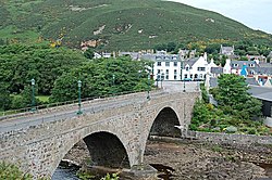
Sluggan Bridge from the south - geograph.org.uk - 142814

(c) Jim Bain, CC BY-SA 2.0

Autor/Urheber:
Größe:
640 x 480 Pixel (343741 Bytes)
Beschreibung:
Sluggan Bridge from the south. Sluggan Bridge from the south and upstream. – According to most reports this bridge dates from the 1830's when it was built to replaced the original military bridge. That two arch bridge built by Major Caulfield or Caulfeild was washed away in The Muckle Spate of Aug 3rd-4th 1829 when the flood levels topped 15 yards in some places. The bridge fell into disuse when the line of the new Inverness Perth parliamentary road moved about 3k downstream to cross the river at Carrbridge around 1834. Repairs to the bridge with funds from Highland council and Sustrans saw it reopen on the 26th of June 2002 and it now forms part of the cycle and walking route north between Perth and Inverness.
Kommentar zur Lizenz:
Dieses Bild stammt aus der Sammlung des Projektes „Geograph British Isles“. Siehe die Seite der Fotografie für Kontaktinformationen. Das Urheberrecht dieses Bildes liegt bei Jim Bain und ist lizenziert unter der Creative Commons Namensnennung-Weitergabe unter gleichen Bedingungen-2.0-Lizenz.
Lizenz:
Credit:
Bild teilen:
Facebook   Twitter   Pinterest   WhatsApp   Telegram   E-Mail
Weitere Informationen zur Lizenz des Bildes finden Sie hier. Letzte Aktualisierung: Sun, 07 Apr 2024 04:22:33 GMT

Relevante Bilder

(c) Jim Bain, CC BY-SA 2.0
(c) Stanley Howe, CC BY-SA 2.0
(c) Des Colhoun, CC BY-SA 2.0
(c) Dave Napier, CC BY-SA 2.0
(c) Roger Davies, CC BY-SA 2.0
(c) Jim Bain, CC BY-SA 2.0
(c) Stephen Branley, CC BY-SA 2.0
(c) Nicholas Mutton, CC BY-SA 2.0
(c) Bill Henderson, CC BY-SA 2.0
(c) Des Colhoun, CC BY-SA 2.0
(c) David Bowie, CC BY-SA 2.0
(c) John Allan, CC BY-SA 2.0
(c) J M Briscoe, CC BY-SA 2.0
(c) Craig Wallace, CC BY-SA 2.0
(c) Colin Wilson, CC BY-SA 2.0
(c) Colin Park, CC BY-SA 2.0
(c) Colin Smith, CC BY-SA 2.0
(c) Richard Webb, CC BY-SA 2.0
(c) Bob Jones, CC BY-SA 2.0
(c) Russel Wills, CC BY-SA 2.0
(c) Anne Burgess, CC BY-SA 2.0
(c) James Allan, CC BY-SA 2.0
(c) David Dixon, CC BY-SA 2.0
(c) C A Millar, CC BY-SA 2.0
(c) Ann Harrison, CC BY-SA 2.0
(c) Jim Barton, CC BY-SA 2.0
(c) Mike Pennington, CC BY-SA 2.0
(c) Thelma Smart, CC BY-SA 2.0
(c) John Jessiman, CC BY-SA 2.0
(c) Julian Paren, CC BY-SA 2.0
(c) John Ferguson, CC BY-SA 2.0
(c) Steven Brown, CC BY-SA 2.0
(c) David Medcalf, CC BY-SA 2.0
(c) John S Ross, CC BY-SA 2.0
(c) Glen Breaden, CC BY-SA 2.0
(c) Peter Moore, CC BY-SA 2.0
(c) Colin Smith, CC BY-SA 2.0
(c) Kirsty Jarman, CC BY-SA 2.0
(c) Des Colhoun, CC BY-SA 2.0
(c) Donald Bain, CC BY-SA 2.0
(c) John Allan, CC BY-SA 2.0

Relevante Artikel

Dulnain

Der Dulnain, schottisch-gälisch Tuilnean, ist ein Fluss in der schottischen Council Area Highland. Er entsteht durch den Zusammenfluss dreier Quellbäche in 790 m Höhe in den Monadhliath Mountains in der traditionellen schottischen Grafschaft Inverness-shire. Von dort aus fließt er 45 km in nordöstlicher Richtung. Der Lauf des Dulnain dreht sukzessive nach Osten ab. Die letzten zwei Kilometer vor der Mündung in den Spey bei Dulnain Bridge in 215 m Höhe verlaufen in südöstlicher Richtung. Der Dulnain überwindet insgesamt einen Höhenunterschied von 575 m. .. weiterlesen

Liste der Kategorie-A-Bauwerke in Highland

Die Liste der Kategorie-A-Gebäude in Highland umfasst sämtliche in der Kategorie A eingetragenen Baudenkmäler in der schottischen Council Area Highland. Die Einstufung wird anhand der Kriterien von Historic Scotland vorgenommen, wobei in die höchste Kategorie A Bauwerke von nationaler oder internationaler Bedeutung einsortiert sind. In Highland sind derzeit 183 Bauwerke in der Kategorie A gelistet. .. weiterlesen