Schokalsky Bay, Antarctica
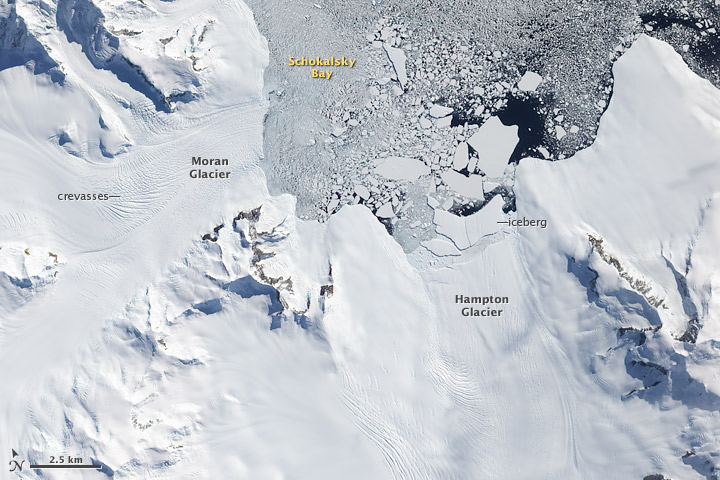
This image of the northern tip of Alexander Island, near the western base of the Antarctic Peninsula, illustrates one of the processes through which glaciers can contribute to sea level rise: iceberg production. In this image, several large icebergs have calved from Hampton Glacier. Near the glacier, the bergs appear to be partially held in place by a mélange of ice that may include tiny iceberg fragments and frozen sea water. Farther out in Shokalsky Bay, the icebergs are floating more freely. Eventually, the bergs will drift northward to warmer waters, where they will melt.
All glaciers that end in the ocean (called tidewater glaciers) periodically calve icebergs. When iceberg production is matched by snowfall accumulation on the glacier, the glacier is not contributing to sea level rise: all the water it adds to the ocean eventually returns to the glacier as snow. But if iceberg production (or a combination of iceberg production and melting) outpaces snowfall accumulation, then the glacier is contributing to sea level rise.
Measuring the thickness and flow rates of glaciers on the Antarctic Peninsula is one of the objectives of an upcoming NASA aircraft campaign called Operation Ice Bridge. Beginning on October 12, 2009, and continuing for 6 weeks, NASA’s DC-8 research airplane and the Ice Bridge team scientists will make a series of flights from a base in southern Chile to collect observations over West Antarctica, the Antarctic Peninsula, and coastal areas where sea ice is prevalent. Each round-trip flight lasts about eleven hours, two-thirds of that time devoted to getting to and from Antarctica.
References
Pritchard, H.D., and Vaughan, D.G. (2007). Widespread acceleration of tidewater glaciers on the Antarctic Peninsula. Journal of Geophysical Research, 112, F03S29.


Relevante Bilder

Relevante Artikel
SchokalskibuchtDie Schokalskibucht ist eine Bucht, die sich über 10 km Länge zwischen dem Mount Calais und dem Kap Brown an der Ostküste der antarktischen Alexander-I.-Insel erstreckt. Vom Hampton-Gletscher kalben enorme Eismassen über einen steilen und stark zerklüfteten Gletscherbruch in die Bucht, weshalb sie nicht als sicherer Ankerplatz und der Gletscher gleichsam nicht als Aufstiegsroute in das Innere der Insel in Frage kommen. .. weiterlesen
Hampton-GletscherDer Hampton-Gletscher ist ein Gletscher im Nordosten der Alexander-I.-Insel westlich der Antarktischen Halbinsel. Er fließt entlang der Westwand der Douglas Range in nordnordöstlicher Richtung zur Schokalskibucht. .. weiterlesen
Walter-GletscherDer Walter-Gletscher ist ein Gletscher im Nordosten der westantarktischen Alexander-I.-Insel. Er fließt in ostnordöstlicher Richtung und mündet in die Südflanke des Moran-Gletschers, kurz bevor dieser die Schokalskibucht erreicht. .. weiterlesen
Douglas RangeDie Douglas Range ist ein 120 km langes und steil aufragendes Küstengebirge mit nordwest-südöstlicher Ausrichtung auf der Ostseite der westantarktischen Alexander-I.-Insel. Der Gebirgszug erstreckt sich vom Mount Nicholas bis zum Mount Edred und überragt den nördlichen Teil des George-VI-Sunds. .. weiterlesen
Mount NicholasMount Nicholas ist ein 1465 m hoher Berg im Nordosten der westantarktischen Alexander-I.-Insel. Er ragt 9 km südsüdwestlich des Kap Brown auf und bildet den nördlichen Ausläufer der Douglas Range. .. weiterlesen