Mount Nicholas
| Mount Nicholas | ||
|---|---|---|
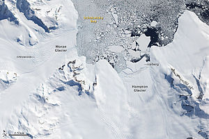
 Satellitenaufnahme aus dem Jahr 2009 des nördlichen Endes der Douglas Range mit Mount Nicholas (rechts) östlich des Hampton-Gletschers | ||
| Höhe | 1465 m | |
| Lage | Alexander-I.-Insel, Antarktis | |
| Gebirge | Douglas Range | |
| Koordinaten | 69° 21′ 56″ S, 69° 51′ 10″ W | |
| ||
| Normalweg | Hochtour (vergletschert) | |
Mount Nicholas (in Chile Monte Nicolás II) ist ein 1465 m (nach Angaben des UK Antarctic Place-Names Committee 1350 m) hoher Berg im Nordosten der westantarktischen Alexander-I.-Insel. Er ragt 9 km südsüdwestlich des Kap Brown auf und bildet den nördlichen Ausläufer der Douglas Range.
Erstmals gesichtet und grob kartiert wurde er 1909 bei der Fünften Französischen Antarktisexpedition (1908–1910) unter der Leitung Jean-Baptiste Charcots, der den Berg in irrtümlicher Annahme, es handele sich um eine Insel, fälschlich als Ile Nicolas II nach dem russischen Zar Nikolaus II. (1868–1918) benannte. Nach der Auswertung von Luftaufnahmen, die 1937 bei der British Graham Land Expedition (1934–1937) unter der Leitung des australischen Polarforschers John Rymill entstanden, änderte sich die Benennung gleichfalls irrtümlich in Kap Nicholas, und dies für einen 42 km weiter nordnordwestlich gelegenen Ausläufer des Mount Calais. Erst durch Vermessungsarbeiten des Falkland Islands Dependencies Survey im Jahr 1948 konnte die ursprünglich von Charcot benannte Insel als Berg identifiziert werden.
Weblinks
- Mount Nicholas. In: Geographic Names Information System. United States Geological Survey, United States Department of the Interior, archiviert vom Original (englisch). (englisch)
- Mount Nicholas auf geographic.org (englisch)
Auf dieser Seite verwendete Medien
(c) Karte: NordNordWest, Lizenz: Creative Commons by-sa-3.0 de
Positionskarte der Antarktischen Halbinsel
Few places on Earth have warmed more rapidly in recent decades than the Antarctic Peninsula, a narrow, mountainous spine of land that juts out from the continent into the Southern Ocean. More than 400 glaciers—often steep and heavily traced with crevasses—flow out of nearly every nook and cranny of the rugged peninsula, and the regional warming has caused the edges of many of these glaciers to retreat and their flow toward the ocean to accelerate. Faster flow of tidewater glaciers on the Antarctic Peninsula is adding directly to sea level rise.
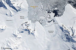
This image of the northern tip of Alexander Island, near the western base of the Antarctic Peninsula, illustrates one of the processes through which glaciers can contribute to sea level rise: iceberg production. In this image, several large icebergs have calved from Hampton Glacier. Near the glacier, the bergs appear to be partially held in place by a mélange of ice that may include tiny iceberg fragments and frozen sea water. Farther out in Shokalsky Bay, the icebergs are floating more freely. Eventually, the bergs will drift northward to warmer waters, where they will melt.
All glaciers that end in the ocean (called tidewater glaciers) periodically calve icebergs. When iceberg production is matched by snowfall accumulation on the glacier, the glacier is not contributing to sea level rise: all the water it adds to the ocean eventually returns to the glacier as snow. But if iceberg production (or a combination of iceberg production and melting) outpaces snowfall accumulation, then the glacier is contributing to sea level rise.
Measuring the thickness and flow rates of glaciers on the Antarctic Peninsula is one of the objectives of an upcoming NASA aircraft campaign called Operation Ice Bridge. Beginning on October 12, 2009, and continuing for 6 weeks, NASA’s DC-8 research airplane and the Ice Bridge team scientists will make a series of flights from a base in southern Chile to collect observations over West Antarctica, the Antarctic Peninsula, and coastal areas where sea ice is prevalent. Each round-trip flight lasts about eleven hours, two-thirds of that time devoted to getting to and from Antarctica.
References
Pritchard, H.D., and Vaughan, D.G. (2007). Widespread acceleration of tidewater glaciers on the Antarctic Peninsula. Journal of Geophysical Research, 112, F03S29.

