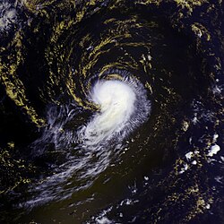
Sepat 16 aug 2007 0225Z
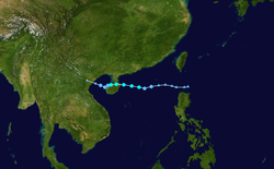
Super Typhoon Sepat came ashore in Taiwan on August 17, 2007, after bringing torrential rain and flooding to the Philippines the day before. Flights to and from Tapei, the island’s capital, were canceled and Chinese authorities were calling all ships at sea to come back to shore in anticipation of the powerful typhoon crossing the Taiwan Strait and coming ashore on the mainland, said news reports. The typhoon was classified as Category Five typhoon, at the very top of the scale, with sustained winds of 184 kilometers per hour (114 miles per hour), according to CNN.
At 10:25 a.m. local time (02:25 UTC) on August 16, 2007, when the Moderate Resolution Imaging Spectroradiometer (MODIS) on NASA’s Terra satellite captured this image, Super Typhoon Sepat was still well away from its coming encounter with the Philippines and Taiwan. Winds were measured at a sustained speed as high as 257 km/hr (161 mph) at the time of this image, according to the University of Hawaii’s Tropical Storm Information Center. The storm’s strength is evident in this image from its large size, well-defined spiral structure, and obvious large eye. Some clouds are present in the central eye: a completely clear eye is a tell-tale sign of the most powerful storms, though some clouds can be present in the eye of a powerful storm as is the case here.| Diese Datei ist gemeinfrei (public domain), da sie von der NASA erstellt worden ist. Die NASA-Urheberrechtsrichtlinie besagt, dass „NASA-Material nicht durch Urheberrecht geschützt ist, wenn es nicht anders angegeben ist“. (NASA-Urheberrechtsrichtlinie-Seite oder JPL Image Use Policy). |  | |
 |
Warnung:
|
Relevante Bilder
Relevante Artikel
Pazifische Taifunsaison 2007Die Pazifische Taifunsaison 2007 dauerte vom 1. Januar bis 31. Dezember 2007, obwohl sich die meisten Zyklone im nordwestlichen Pazifischen Ozean zwischen Mai und November bilden. Tropische Stürme, die sich auf der Nordhalbkugel im Pazifischen Ozean westlich der Datumsgrenze bildeten, nennt man Taifune. Die sich 2007 im Pazifischen Ozean östlich der Datumsgrenze und nördlich des Äquators gebildeten Hurrikane sind Gegenstand der Pazifischen Hurrikansaison 2007. Tropische Stürme, die sich im Bereich des westlichen Pazifischen Ozeanes bilden, werden durch die Japan Meteorological Agency (JMA) mit einem Namen versehen. Tropische Tiefdruckgebiete in diesem Becken erhalten das Suffix „W“ zu der laufenden Nummerierung durch das Joint Typhoon Warning Center. Tropische Systeme, die sich im Verantwortungsbereich der Philippinen bilden oder in diesen hineinwandern, erhalten einen Namen durch die Philippine Atmospheric, Geophysical and Astronomical Services Administration (PAGASA). Dies kann dazu führen, dass Stürme zwei verschiedene Namen haben. .. weiterlesen


