MH370 SearchAreaMap June 2014
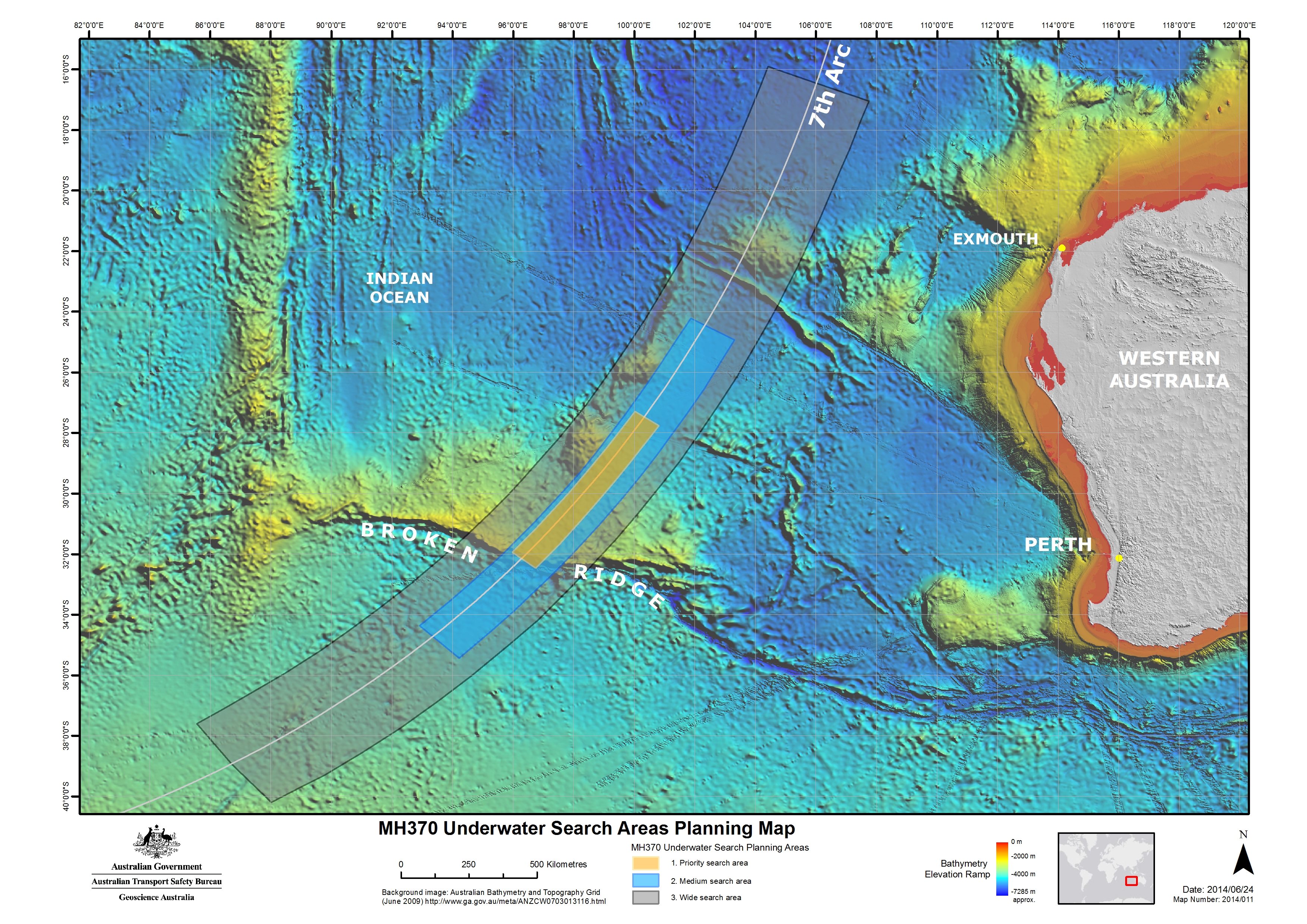
Note:All three versions uploaded are identical, which includes the date (2014/06/24) and "Map number" (2014/011). The only difference is the pixel size.
The third version (4 October 2014) uploaded is from the ATSB website, which states on the "Copyright" page: "Apart from the Coat of Arms, the ATSB logo, photos and graphics in which a third party has copyright, our investigation reports are licensed under the Creative Commons Attribution 3.0 Australia Licence."
The second version (30 July 2014) uploaded was extracted from a report by the ATSB which states (pg. 2): "With the exception of the Coat of Arms, ATSB logo, and photos and graphics in which a third party holds copyright, this publication is licensed under a Creative Commons Attribution 3.0 Australia license." The background bathymetric image comes from here, listing "Access constraints: No restrictions". Per the Geoscience Australia website: "Unless otherwise noted, all Geoscience Australia material on this website is licensed under the Creative Commons Attribution 3.0 Australia Licence."
The original version (27 June 2014) was obtained from JACC (a link from this press release) because I was unable to figure out, at the time, how to extract the image from the ATSB report (PDF). The JACC claimed copyright to content on its website, but the image was seemingly identical (visual appearance & id number: "Map 2014/011") to the map in the ATSB report, which was later uploaded.


Relevante Bilder


_de.svg)


_9M-MRO_-_MSN_28420_404_retusche.jpg)
.jpg)


.JPG)


.svg)


.jpg)

.svg)


.svg)


Relevante Artikel
Malaysia-Airlines-Flug 370Der Malaysia-Airlines-Flug 370 war ein internationaler Linienflug von Kuala Lumpur nach Peking, bei dem eine Boeing 777 der Malaysia Airlines am 8. März 2014 aus der Überwachung der Flugverkehrskontrolle des Flughafens von Kuala Lumpur verschwand und plötzlich die Richtung änderte. Bislang wurde keine offizielle Ursache für das Verschwinden des Fluges MH370 genannt. Der Vorfall wird daher als eines der größten Rätsel der Luftfahrtgeschichte bezeichnet. Die aus Radar- und Satellitendaten gewonnenen Erkenntnisse legen allerdings − zumindest für die vom Radar erfasste Flugphase und die aus Satellitendaten abgeleitete anschließende Wende nach Süden – eine vorsätzliche Handlung durch einen Piloten oder durch Flugzeugentführer nahe. Da das Hauptwrack bisher nicht lokalisiert werden konnte, gilt Flug MH370 bis heute als vermisst. .. weiterlesen