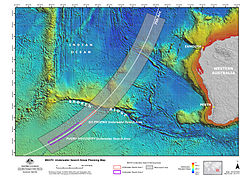
Bathymetry of the MH370 Search Area
Note: The video description states it is released under a "Creative Commons Attribution 4.0 Australia licence", but provides a link to the 'Creative Commons Attribution 4.0 International' license. At the time of upload, there was no Creative Commons Attribution 4.0 Australia license (the most recent version was the Creative Commons Attribution 3.0 Australia license). It is assumed, due to the link, that this file is licensed with a 'Creative Commons Attribution 4.0 International' license. The exact words used to describe the license are:
"You may use this material under a creative commons licence for the work in the following terms:
Creative Commons Attribution 4.0 Australia licence.
Creative Commons Attribution 4.0 Australia Licence is a standard form license agreement that allows you to copy, distribute, transmit and adapt this publication provided that you attribute the work. See: https://creativecommons.org/licenses/by/4.0/
You should attribute this video using the following wording: Source: Geoscience Australia"Relevante Bilder


Relevante Artikel
Malaysia-Airlines-Flug 370Der Malaysia-Airlines-Flug 370 war ein internationaler Linienflug von Kuala Lumpur nach Peking, bei dem eine Boeing 777 der Malaysia Airlines am 8. März 2014 aus der Überwachung der Flugverkehrskontrolle des Flughafens von Kuala Lumpur verschwand und plötzlich die Richtung änderte. Bislang wurde keine offizielle Ursache für das Verschwinden des Fluges MH370 genannt. Der Vorfall wird daher als eines der größten Rätsel der Luftfahrtgeschichte bezeichnet. Die aus Radar- und Satellitendaten gewonnenen Erkenntnisse legen allerdings − zumindest für die vom Radar erfasste Flugphase und die aus Satellitendaten abgeleitete anschließende Wende nach Süden – eine vorsätzliche Handlung durch einen Piloten oder durch Flugzeugentführer nahe. Da das Hauptwrack bisher nicht lokalisiert werden konnte, gilt Flug MH370 bis heute als vermisst. .. weiterlesen
