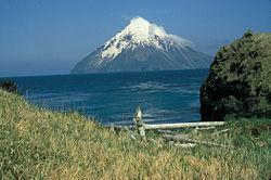
Kagamil
Autor/Urheber:
G. Vernon Byrd (U.S. Fish and Wildlife Service, courtesy of Alaska Volcano Observatory)
Shortlink:
Quelle:
Größe:
640 x 412 Pixel (31248 Bytes)
Beschreibung:
The southern half of 5 x 10 km Kagamil Island in the NE part of the "Islands of Four Mountains" group contains two undissected cones of postglacial age with small summit craters. The larger, 893-m-high cone (center) is seen here from the SW and is located at the SE end of the NNW-SSE-trending volcano. Hot springs and fumaroles occur near the SE coast. The early explorer Veniaminof indicated that Kagamil, also known as Kigamiljach, formerly "flamed and smoked," but the only eruptive report is of unspecified activity in 1929.
Kommentar zur Lizenz:
This image or recording is the work of a U.S. Fish and Wildlife Service employee, taken or made as part of that person's official duties. As a work of the U.S. federal government, the image is in the public domain. For more information, see the Fish and Wildlife Service copyright policy.
Lizenz:
Public domain
Relevante Bilder
Relevante Artikel
Kagamil IslandKagamil Island ist eine der Islands of Four Mountains, einer Inselgruppe der Aleuten in Alaska. Sie liegt 6 km nördlich von Chuginadak Island und ist 2 km südlich von Uliaga Island entfernt. Sie ist 10 km lang und 5 km breit. Die Insel ist schwer zu erreichen. .. weiterlesen
Liste von Vulkanen in den Vereinigten StaatenDies ist eine Liste von Vulkanen in den USA, die während des Quartärs mindestens einmal aktiv waren. .. weiterlesen


