Gonu rainfall
Despite weakening from a Category 5 to a Category 1 cyclone as it neared the Arabian Peninsula, Tropical Cyclone Gonu was responsible for at least 28 fatalities in the region, mostly as a result of flooding, said news reports. In Oman’s capital city of Muscat, torrential rains turned streets into rivers of water in this normally arid region. In addition to the 25 confirmed fatalities in Oman, at least 26 other people were reported missing. Iran had reported 3 deaths as a result of the storm as of June 7, 2007.
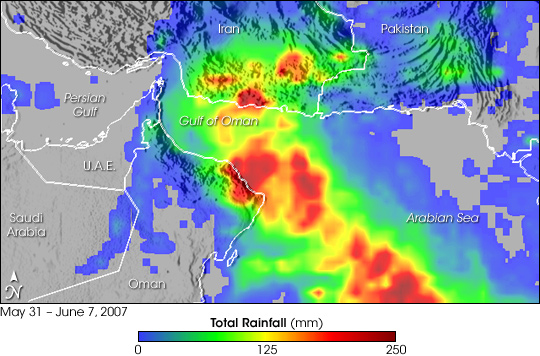
This visualization shows rainfall totals from May 31 through June 7, 2007, from the Multi-satellite Precipitation Analysis (MPA). Although the center of Gonu never made landfall in Oman, it came very close to the northeast coastline where it dumped upwards up 200 millimeters of rain (8 inches, shown in dark red). The capital region of Muscat is on the coast where some of the heaviest rain fell. Despite further weakening as it traversed the Gulf of Oman between Oman and southern Iran, Gonu dumped substantial amounts of rain in southern Iran (broad green area) with locally heavy amounts. The mountainous terrain near the coast of Oman and Iran posed an additional hazard to coastal regions. Heavy rain falling on the steep mountains sent torrents of fast-moving floodwater down to the coastal areas.
The MPA is computed at NASA Goddard Space Flight center in near-real time using data from the Tropical Rainfall Measuring Mission (TRMM). The TRMM satellite was placed into service in November 1997. From its low-earth orbit, TRMM provides valuable images and information on storm systems around the tropics using a combination of passive microwave and active radar sensors, including the first precipitation radar in space. TRMM is a joint mission between NASA and the Japanese space agency, JAXA.


Relevante Bilder


Relevante Artikel
Zyklon GonuZyklon Gonu war der stärkste bisher bekannte tropische Wirbelsturm im Arabischen Meer und gemeinsam mit einem anderen Zyklon auch der stärkste bekannte Wirbelsturm im nördlichen Indischen Ozean überhaupt. Gonu war der zweite benamte Sturm der Wirbelsturmsaison in nördlichen Indischen Ozean 2007 und entwickelte sich am 1. Juni aus einem dauerhaften Konvektionsgebiet im östlichen Bereich des Arabischen Meeres. Aufgrund günstiger Bedingungen in der Höhe und der warmen Wasseroberfläche begann eine rapide Intensivierung, die Gonu am 3. Juni nach den Angaben des India Meteorological Department Spitzenwindgeschwindigkeiten von 240 km/h erreichen ließen. Gonu schwächte sich zwar etwas ab, da der Sturm auf trockene Luft und ¨kühleres Wasser stieß, war aber am Abend des 5. Juni bei seinem Auftreffen auf die Ostspitze Omans der stärkste tropische Wirbelsturm, der seit Beginn der Beobachtungen auf die Arabische Halbinsel traf. Wirbelstürme solcher Intensität sind im Arabischen Meer selten, weil die meisten tropischen Wirbelstürme in diesem Gebiet einen eher geringen Durchmesser haben und sich schnell auflösen. .. weiterlesen