Dunkeld Cathedral
Relevante Bilder
![](https://upload.wikimedia.org/wikipedia/commons/thumb/5/50/The_Tower_Dunkeld_Cathedral.jpg/125px-The_Tower_Dunkeld_Cathedral.jpg)
![](https://upload.wikimedia.org/wikipedia/commons/thumb/b/be/The_Nave%2C_Dunkeld_Cathedral_-_geograph.org.uk_-_971382.jpg/250px-The_Nave%2C_Dunkeld_Cathedral_-_geograph.org.uk_-_971382.jpg)
![](https://upload.wikimedia.org/wikipedia/commons/thumb/b/bc/Perth_and_Kinross_Dunkeld_Cathedral_Alexander_Stewart_1.jpg/250px-Perth_and_Kinross_Dunkeld_Cathedral_Alexander_Stewart_1.jpg)
![](https://upload.wikimedia.org/wikipedia/commons/thumb/5/56/Perth_and_Kinross_Dunkeld_Cathedral_Apostles%27_Stone_1.jpg/125px-Perth_and_Kinross_Dunkeld_Cathedral_Apostles%27_Stone_1.jpg)
![](https://upload.wikimedia.org/wikipedia/commons/thumb/b/b5/Platform_at_Dunkeld_and_Birnam_Railway_Station_-_geograph.org.uk_-_1587478.jpg/250px-Platform_at_Dunkeld_and_Birnam_Railway_Station_-_geograph.org.uk_-_1587478.jpg)
![](https://upload.wikimedia.org/wikipedia/commons/thumb/f/ff/Dunkeld_Bridge_-_geograph.org.uk_-_1202125.jpg/250px-Dunkeld_Bridge_-_geograph.org.uk_-_1202125.jpg)
![](https://upload.wikimedia.org/wikipedia/commons/thumb/9/94/Tummel_Bridge_Power_Station_-_geograph.org.uk_-_776149.jpg/250px-Tummel_Bridge_Power_Station_-_geograph.org.uk_-_776149.jpg)
![](https://upload.wikimedia.org/wikipedia/commons/thumb/9/98/Murthly_Castle_Chapel_-_geograph.org.uk_-_424698.jpg/250px-Murthly_Castle_Chapel_-_geograph.org.uk_-_424698.jpg)
![](https://upload.wikimedia.org/wikipedia/commons/thumb/2/21/Dry_Arch%2C_Dalcrue%2C_Perthshire._-_geograph.org.uk_-_74247.jpg/250px-Dry_Arch%2C_Dalcrue%2C_Perthshire._-_geograph.org.uk_-_74247.jpg)
![](https://upload.wikimedia.org/wikipedia/commons/thumb/8/89/St_Ninian%27s_Cathedral%2C_Perth_%28Scotland%29.jpg/125px-St_Ninian%27s_Cathedral%2C_Perth_%28Scotland%29.jpg)
![](https://upload.wikimedia.org/wikipedia/commons/thumb/8/84/Pitheavlis_Castle_-_geograph.org.uk_-_959560.jpg/250px-Pitheavlis_Castle_-_geograph.org.uk_-_959560.jpg)
![](https://upload.wikimedia.org/wikipedia/commons/thumb/c/c4/Megginch_Castle_gatehouse_-_geograph.org.uk_-_377931.jpg/250px-Megginch_Castle_gatehouse_-_geograph.org.uk_-_377931.jpg)
![](https://upload.wikimedia.org/wikipedia/commons/thumb/7/7d/Doocot%2C_Megginch_Castle._-_geograph.org.uk_-_214392.jpg/125px-Doocot%2C_Megginch_Castle._-_geograph.org.uk_-_214392.jpg)
![](https://upload.wikimedia.org/wikipedia/commons/thumb/1/14/Tullibole_Castle_-_geograph.org.uk_-_116622.jpg/250px-Tullibole_Castle_-_geograph.org.uk_-_116622.jpg)
![](https://upload.wikimedia.org/wikipedia/commons/thumb/3/32/Keathbank_Mill_beside_River_Ericht%2C_Blairgowrie_-_geograph.org.uk_-_962534.jpg/250px-Keathbank_Mill_beside_River_Ericht%2C_Blairgowrie_-_geograph.org.uk_-_962534.jpg)
![](https://upload.wikimedia.org/wikipedia/commons/thumb/6/6a/Chapel_Scone_Palace_%2C_Perth_-_geograph.org.uk_-_452978.jpg/250px-Chapel_Scone_Palace_%2C_Perth_-_geograph.org.uk_-_452978.jpg)
![](https://upload.wikimedia.org/wikipedia/commons/thumb/7/76/Murthly_Castle_-_geograph.org.uk_-_424676.jpg/250px-Murthly_Castle_-_geograph.org.uk_-_424676.jpg)
![](https://upload.wikimedia.org/wikipedia/commons/thumb/a/aa/A_shop_in_the_main_street_with_an_interesting_design._-_geograph.org.uk_-_745712.jpg/250px-A_shop_in_the_main_street_with_an_interesting_design._-_geograph.org.uk_-_745712.jpg)
![](https://upload.wikimedia.org/wikipedia/commons/thumb/c/ca/Aberuchill_Castle_-_geograph.org.uk_-_670086.jpg/250px-Aberuchill_Castle_-_geograph.org.uk_-_670086.jpg)
![](https://upload.wikimedia.org/wikipedia/commons/thumb/f/fa/Chinese_Bridge%2C_Taymouth_Castle_%28geograph_2025598%29.jpg/250px-Chinese_Bridge%2C_Taymouth_Castle_%28geograph_2025598%29.jpg)
![](https://upload.wikimedia.org/wikipedia/commons/thumb/3/3f/Former_bank_building_on_St_John_Street_%28geograph_4257401%29.jpg/250px-Former_bank_building_on_St_John_Street_%28geograph_4257401%29.jpg)
![](https://upload.wikimedia.org/wikipedia/commons/thumb/a/a2/Lower_City_Mills%2C_Perth_-_geograph.org.uk_-_12129.jpg/250px-Lower_City_Mills%2C_Perth_-_geograph.org.uk_-_12129.jpg)
![](https://upload.wikimedia.org/wikipedia/commons/thumb/d/db/Wade%27s_Bridge_over_the_River_Tay%2C_Aberfeldy_-_geograph.org.uk_-_432981.jpg/250px-Wade%27s_Bridge_over_the_River_Tay%2C_Aberfeldy_-_geograph.org.uk_-_432981.jpg)
![](https://upload.wikimedia.org/wikipedia/commons/thumb/6/61/Tummel_Bridge_-_geograph.org.uk_-_152638.jpg/125px-Tummel_Bridge_-_geograph.org.uk_-_152638.jpg)
![](https://upload.wikimedia.org/wikipedia/commons/thumb/7/7f/St._Leonard%27s-in-the-Fields_-_geograph.org.uk_-_1469806.jpg/125px-St._Leonard%27s-in-the-Fields_-_geograph.org.uk_-_1469806.jpg)
![](https://upload.wikimedia.org/wikipedia/commons/thumb/5/5c/Sunnybrae_Cottage_-_geograph.org.uk_-_658435.jpg/250px-Sunnybrae_Cottage_-_geograph.org.uk_-_658435.jpg)
![](https://upload.wikimedia.org/wikipedia/commons/thumb/d/d3/Gates_to_Blair_Castle_-_geograph.org.uk_-_1588272.jpg/250px-Gates_to_Blair_Castle_-_geograph.org.uk_-_1588272.jpg)
![](https://upload.wikimedia.org/wikipedia/commons/thumb/b/b1/Blackcraig_Castle_-_geograph.org.uk_-_349221.jpg/250px-Blackcraig_Castle_-_geograph.org.uk_-_349221.jpg)
![](https://upload.wikimedia.org/wikipedia/commons/thumb/d/d2/War_Memorial_Blairgowrie_-_geograph.org.uk_-_26302.jpg/125px-War_Memorial_Blairgowrie_-_geograph.org.uk_-_26302.jpg)
![](https://upload.wikimedia.org/wikipedia/commons/thumb/8/8a/Grandtully_Castle_%28geograph_3890325%29.jpg/250px-Grandtully_Castle_%28geograph_3890325%29.jpg)
![](https://upload.wikimedia.org/wikipedia/commons/thumb/d/d7/Entrance%2C_HMP_Castle_Huntly_%28geograph_1853027%29.jpg/250px-Entrance%2C_HMP_Castle_Huntly_%28geograph_1853027%29.jpg)
![](https://upload.wikimedia.org/wikipedia/commons/thumb/0/04/Stobhall_Castle_and_chapel_-_geograph.org.uk_-_82721.jpg/250px-Stobhall_Castle_and_chapel_-_geograph.org.uk_-_82721.jpg)
![](https://upload.wikimedia.org/wikipedia/commons/thumb/8/8d/Monzie_Castle_-_geograph.org.uk_-_1632618.jpg/250px-Monzie_Castle_-_geograph.org.uk_-_1632618.jpg)
![](https://upload.wikimedia.org/wikipedia/commons/thumb/5/5b/Rannoch_Powerstation_-_geograph.org.uk_-_111831.jpg/250px-Rannoch_Powerstation_-_geograph.org.uk_-_111831.jpg)
![](https://upload.wikimedia.org/wikipedia/commons/thumb/8/88/Kenmore_bridge_-_geograph.org.uk_-_1239966.jpg/250px-Kenmore_bridge_-_geograph.org.uk_-_1239966.jpg)
![](https://upload.wikimedia.org/wikipedia/commons/thumb/0/02/Innerpeffray_Library_-_geograph.org.uk_-_581585.jpg/250px-Innerpeffray_Library_-_geograph.org.uk_-_581585.jpg)
![](https://upload.wikimedia.org/wikipedia/commons/thumb/1/13/Glenalmond_College_-_geograph.org.uk_-_1305507.jpg/400px-Glenalmond_College_-_geograph.org.uk_-_1305507.jpg)
![](https://upload.wikimedia.org/wikipedia/commons/thumb/c/c9/Pitlochry_Railway_Station_-_geograph.org.uk_-_776524.jpg/250px-Pitlochry_Railway_Station_-_geograph.org.uk_-_776524.jpg)
![](https://upload.wikimedia.org/wikipedia/commons/thumb/5/5f/Perth_Bridge_and_the_River_Tay_-_geograph.org.uk_-_1077778.jpg/250px-Perth_Bridge_and_the_River_Tay_-_geograph.org.uk_-_1077778.jpg)
![](https://upload.wikimedia.org/wikipedia/commons/thumb/c/c7/St_Serf%27s_Church%2C_Dunning.jpg/125px-St_Serf%27s_Church%2C_Dunning.jpg)
Relevante Artikel
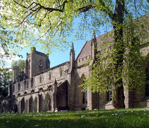
Dunkeld CathedralDie Dunkeld Cathedral ist eine heute teilweise in Ruinen liegende ehemalige Kathedrale in der schottischen Ortschaft Dunkeld in der Council Area Perth and Kinross. 1971 wurde das Bauwerk in die schottischen Denkmallisten in der höchsten Denkmalkategorie A aufgenommen. Des Weiteren ist die Anlage als Scheduled Monument geschützt. .. weiterlesen
Liste der Kategorie-A-Bauwerke in Perth and KinrossDie Liste der Kategorie-A-Gebäude in Perth and Kinross umfasst sämtliche in der Kategorie A eingetragenen Baudenkmäler in der schottischen Council Area Perth and Kinross. Die Einstufung wird anhand der Kriterien von Historic Scotland vorgenommen, wobei in die höchste Kategorie A Bauwerke von nationaler oder internationaler Bedeutung einsortiert sind. In Perth and Kinross sind derzeit 158 Bauwerke in der Kategorie A gelistet. .. weiterlesen