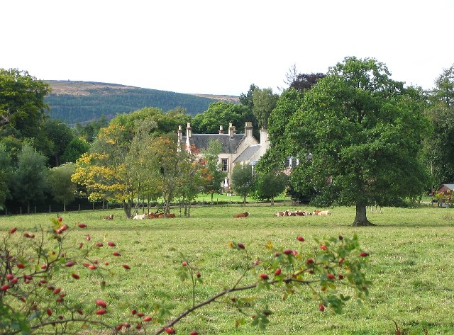
Drummonie House - geograph.org.uk - 55034
Relevante Bilder
![](https://upload.wikimedia.org/wikipedia/commons/thumb/5/5b/Ochtertyre_House_-_geograph.org.uk_-_691363.jpg/250px-Ochtertyre_House_-_geograph.org.uk_-_691363.jpg)
![](https://upload.wikimedia.org/wikipedia/commons/thumb/e/ef/Mercat_Cross%2C_Meikleour_-_geograph.org.uk_-_1768792.jpg/250px-Mercat_Cross%2C_Meikleour_-_geograph.org.uk_-_1768792.jpg)
![](https://upload.wikimedia.org/wikipedia/commons/thumb/6/66/Kinross_House_-_geograph.org.uk_-_1210373.jpg/250px-Kinross_House_-_geograph.org.uk_-_1210373.jpg)
![](https://upload.wikimedia.org/wikipedia/commons/thumb/5/59/Inchmartine_House_-_geograph.org.uk_-_726895.jpg/250px-Inchmartine_House_-_geograph.org.uk_-_726895.jpg)
![](https://upload.wikimedia.org/wikipedia/commons/thumb/2/21/Dry_Arch%2C_Dalcrue%2C_Perthshire._-_geograph.org.uk_-_74247.jpg/250px-Dry_Arch%2C_Dalcrue%2C_Perthshire._-_geograph.org.uk_-_74247.jpg)
![](https://upload.wikimedia.org/wikipedia/commons/thumb/2/2d/Longforgan_mercat_cross%2C_Main_Street_%28geograph_3680878%29.jpg/125px-Longforgan_mercat_cross%2C_Main_Street_%28geograph_3680878%29.jpg)
![](https://upload.wikimedia.org/wikipedia/commons/thumb/6/6f/White_Kirk%2C_Comrie_-_geograph.org.uk_-_542916.jpg/250px-White_Kirk%2C_Comrie_-_geograph.org.uk_-_542916.jpg)
![](https://upload.wikimedia.org/wikipedia/commons/thumb/4/4a/Jarvis_Ramada_Mills_Hotel_-_geograph.org.uk_-_452946.jpg/250px-Jarvis_Ramada_Mills_Hotel_-_geograph.org.uk_-_452946.jpg)
![](https://upload.wikimedia.org/wikipedia/commons/thumb/3/32/Keathbank_Mill_beside_River_Ericht%2C_Blairgowrie_-_geograph.org.uk_-_962534.jpg/250px-Keathbank_Mill_beside_River_Ericht%2C_Blairgowrie_-_geograph.org.uk_-_962534.jpg)
![](https://upload.wikimedia.org/wikipedia/commons/thumb/8/84/Pitheavlis_Castle_-_geograph.org.uk_-_959560.jpg/250px-Pitheavlis_Castle_-_geograph.org.uk_-_959560.jpg)
![](https://upload.wikimedia.org/wikipedia/commons/thumb/a/a2/Lower_City_Mills%2C_Perth_-_geograph.org.uk_-_12129.jpg/250px-Lower_City_Mills%2C_Perth_-_geograph.org.uk_-_12129.jpg)
![](https://upload.wikimedia.org/wikipedia/commons/thumb/c/c4/Megginch_Castle_gatehouse_-_geograph.org.uk_-_377931.jpg/250px-Megginch_Castle_gatehouse_-_geograph.org.uk_-_377931.jpg)
![](https://upload.wikimedia.org/wikipedia/commons/thumb/9/94/Tummel_Bridge_Power_Station_-_geograph.org.uk_-_776149.jpg/250px-Tummel_Bridge_Power_Station_-_geograph.org.uk_-_776149.jpg)
![](https://upload.wikimedia.org/wikipedia/commons/thumb/b/b5/Platform_at_Dunkeld_and_Birnam_Railway_Station_-_geograph.org.uk_-_1587478.jpg/250px-Platform_at_Dunkeld_and_Birnam_Railway_Station_-_geograph.org.uk_-_1587478.jpg)
![](https://upload.wikimedia.org/wikipedia/commons/thumb/1/13/Glenalmond_College_-_geograph.org.uk_-_1305507.jpg/400px-Glenalmond_College_-_geograph.org.uk_-_1305507.jpg)
![](https://upload.wikimedia.org/wikipedia/commons/thumb/9/9d/Bridge_at_The_Hermitage_-_geograph.org.uk_-_1587501.jpg/250px-Bridge_at_The_Hermitage_-_geograph.org.uk_-_1587501.jpg)
![](https://upload.wikimedia.org/wikipedia/commons/thumb/d/d2/War_Memorial_Blairgowrie_-_geograph.org.uk_-_26302.jpg/125px-War_Memorial_Blairgowrie_-_geograph.org.uk_-_26302.jpg)
![](https://upload.wikimedia.org/wikipedia/commons/thumb/a/aa/A_shop_in_the_main_street_with_an_interesting_design._-_geograph.org.uk_-_745712.jpg/250px-A_shop_in_the_main_street_with_an_interesting_design._-_geograph.org.uk_-_745712.jpg)
![](https://upload.wikimedia.org/wikipedia/commons/thumb/d/db/Wade%27s_Bridge_over_the_River_Tay%2C_Aberfeldy_-_geograph.org.uk_-_432981.jpg/250px-Wade%27s_Bridge_over_the_River_Tay%2C_Aberfeldy_-_geograph.org.uk_-_432981.jpg)
![](https://upload.wikimedia.org/wikipedia/commons/thumb/5/5c/Sunnybrae_Cottage_-_geograph.org.uk_-_658435.jpg/250px-Sunnybrae_Cottage_-_geograph.org.uk_-_658435.jpg)
![](https://upload.wikimedia.org/wikipedia/commons/thumb/7/7d/Doocot%2C_Megginch_Castle._-_geograph.org.uk_-_214392.jpg/125px-Doocot%2C_Megginch_Castle._-_geograph.org.uk_-_214392.jpg)
![](https://upload.wikimedia.org/wikipedia/commons/thumb/4/4b/Errol_Parish_Church_-_geograph.org.uk_-_104301.jpg/125px-Errol_Parish_Church_-_geograph.org.uk_-_104301.jpg)
![](https://upload.wikimedia.org/wikipedia/commons/thumb/d/d3/Gates_to_Blair_Castle_-_geograph.org.uk_-_1588272.jpg/250px-Gates_to_Blair_Castle_-_geograph.org.uk_-_1588272.jpg)
![](https://upload.wikimedia.org/wikipedia/commons/thumb/5/5f/Perth_Bridge_and_the_River_Tay_-_geograph.org.uk_-_1077778.jpg/250px-Perth_Bridge_and_the_River_Tay_-_geograph.org.uk_-_1077778.jpg)
![](https://upload.wikimedia.org/wikipedia/commons/thumb/7/7e/Errol_Park_-_geograph.org.uk_-_1198696.jpg/250px-Errol_Park_-_geograph.org.uk_-_1198696.jpg)
![](https://upload.wikimedia.org/wikipedia/commons/thumb/3/32/Nether_Gask_-_geograph.org.uk_-_449208.jpg/250px-Nether_Gask_-_geograph.org.uk_-_449208.jpg)
![](https://upload.wikimedia.org/wikipedia/commons/thumb/6/61/Tummel_Bridge_-_geograph.org.uk_-_152638.jpg/125px-Tummel_Bridge_-_geograph.org.uk_-_152638.jpg)
![](https://upload.wikimedia.org/wikipedia/commons/thumb/9/98/Murthly_Castle_Chapel_-_geograph.org.uk_-_424698.jpg/250px-Murthly_Castle_Chapel_-_geograph.org.uk_-_424698.jpg)
![](https://upload.wikimedia.org/wikipedia/commons/thumb/7/7f/St._Leonard%27s-in-the-Fields_-_geograph.org.uk_-_1469806.jpg/125px-St._Leonard%27s-in-the-Fields_-_geograph.org.uk_-_1469806.jpg)
![](https://upload.wikimedia.org/wikipedia/commons/thumb/c/ca/Aberuchill_Castle_-_geograph.org.uk_-_670086.jpg/250px-Aberuchill_Castle_-_geograph.org.uk_-_670086.jpg)
![](https://upload.wikimedia.org/wikipedia/commons/thumb/5/5b/Rannoch_Powerstation_-_geograph.org.uk_-_111831.jpg/250px-Rannoch_Powerstation_-_geograph.org.uk_-_111831.jpg)
![](https://upload.wikimedia.org/wikipedia/commons/thumb/0/04/Stobhall_Castle_and_chapel_-_geograph.org.uk_-_82721.jpg/250px-Stobhall_Castle_and_chapel_-_geograph.org.uk_-_82721.jpg)
![](https://upload.wikimedia.org/wikipedia/commons/thumb/8/88/Kenmore_bridge_-_geograph.org.uk_-_1239966.jpg/250px-Kenmore_bridge_-_geograph.org.uk_-_1239966.jpg)
![](https://upload.wikimedia.org/wikipedia/commons/thumb/0/02/Innerpeffray_Library_-_geograph.org.uk_-_581585.jpg/250px-Innerpeffray_Library_-_geograph.org.uk_-_581585.jpg)
![](https://upload.wikimedia.org/wikipedia/commons/thumb/1/14/Tullibole_Castle_-_geograph.org.uk_-_116622.jpg/250px-Tullibole_Castle_-_geograph.org.uk_-_116622.jpg)
![](https://upload.wikimedia.org/wikipedia/commons/thumb/f/ff/Dunkeld_Bridge_-_geograph.org.uk_-_1202125.jpg/250px-Dunkeld_Bridge_-_geograph.org.uk_-_1202125.jpg)
![](https://upload.wikimedia.org/wikipedia/commons/thumb/c/c9/Pitlochry_Railway_Station_-_geograph.org.uk_-_776524.jpg/250px-Pitlochry_Railway_Station_-_geograph.org.uk_-_776524.jpg)
![](https://upload.wikimedia.org/wikipedia/commons/thumb/b/b1/Blackcraig_Castle_-_geograph.org.uk_-_349221.jpg/250px-Blackcraig_Castle_-_geograph.org.uk_-_349221.jpg)
![](https://upload.wikimedia.org/wikipedia/commons/thumb/d/d4/Doocot_at_Elcho_-_geograph.org.uk_-_1280869.jpg/125px-Doocot_at_Elcho_-_geograph.org.uk_-_1280869.jpg)
![](https://upload.wikimedia.org/wikipedia/commons/thumb/9/9e/Ballindean_House_-_the_home_of_Teen_Ranch_%28geograph_4862857%29.jpg/250px-Ballindean_House_-_the_home_of_Teen_Ranch_%28geograph_4862857%29.jpg)
![](https://upload.wikimedia.org/wikipedia/commons/thumb/8/8d/Monzie_Castle_-_geograph.org.uk_-_1632618.jpg/250px-Monzie_Castle_-_geograph.org.uk_-_1632618.jpg)
![](https://upload.wikimedia.org/wikipedia/commons/thumb/3/3f/Former_bank_building_on_St_John_Street_%28geograph_4257401%29.jpg/250px-Former_bank_building_on_St_John_Street_%28geograph_4257401%29.jpg)
Relevante Artikel
Drummonie HouseDrummonie House ist eine Villa nahe der schottischen Ortschaft Bridge of Earn in der Council Area Perth and Kinross. 1971 wurde das Bauwerk in die schottischen Denkmallisten in der höchsten Denkmalkategorie A aufgenommen. .. weiterlesen
Liste der Kategorie-A-Bauwerke in Perth and KinrossDie Liste der Kategorie-A-Gebäude in Perth and Kinross umfasst sämtliche in der Kategorie A eingetragenen Baudenkmäler in der schottischen Council Area Perth and Kinross. Die Einstufung wird anhand der Kriterien von Historic Scotland vorgenommen, wobei in die höchste Kategorie A Bauwerke von nationaler oder internationaler Bedeutung einsortiert sind. In Perth and Kinross sind derzeit 158 Bauwerke in der Kategorie A gelistet. .. weiterlesen