Delta Mariner at Meck Island orig (2009)
The north-south runway on the right was originally built to accommodate operations by STOL aircraft, notably the De Havilland Canada Caribou and Twin Otter. Strong prevailing winds from the west made for tricky landings and it was later decommissioned. Most transit today is by boat, and the runway area now hosts two helicopter landing pads - only one is seen here, the other appears on photographs as late as 1991 but appears to be decommissioned. The construction area at the south end of the runway (nearer to the camera) is used as a launch site for smaller missiles like THAAD and Patriot.
At the upper part of the the image, framed by the red and white towers, is the main launch area. This was originally built in the 1960s as part of the Sentinel and Safeguard ABM programs. As Meck is only a few feet over sea level, and the missiles were launched from underground silos, the entire area had to be built up into a hill so the silos would not be under water. Seen just below the launch site, although separated by some distance when seen from other angles, is the original Missile Site Radar (MSR) that was built as part of these same tests. The smaller red and white tower on its roof was added later and appears to hold communications gear. The large silver-roofed building to its south hosted the computers, which would normally be under the radar, but were moved here to be above the waterline. The smaller building to the left of the MSR, similarly shaped, is the Site Defense Radar (SDR), essentially a modernized MSR built in the late 1970s. This was built in 1977 on backfilled land that extended the entire area to the west, the former shoreline ran just to the left of the MSR building. Most of the buildings in the photo are from the SDR era or newer, built to support ongoing operations and new launch services.
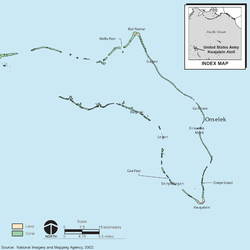
This image is taken looking roughly north-northeast. The small island in the upper left is Kuwatep, and the longer crescent-shaped one further north is Omelek. Eniwetak is just off frame to the left of Kuwatep. Eniwetak and Omelek host a number of camera sites used to photograph launches from Meck.Relevante Bilder
Relevante Artikel
Meck IslandMeck Island ist ein Teil des Kwajalein-Atolls, welches Teil der Ralik-Kette von den Marshallinseln (RMI) ist. Die Insel liegt im Osten des Atolls südlich der Eniwetak Passage. Die Insel gehört zu den von den Vereinigten Staaten gepachteten Gebieten. .. weiterlesen


