Cesam249
Autor/Urheber:
Adrien Lamarre, U.S. Army Corps of Engineers
Shortlink:
Quelle:
Größe:
1500 x 1079 Pixel (413779 Bytes)
Beschreibung:
Aerial view of Millers Ferry Lock and Dam on the Alabama River in Wilcox County, Alabama, USA. The lock and dam are located approximately 9.5 miles (15 km) northwest of Camden, Alabama. The dam impounds William “Bill” Dannelly Reservoir on the Alabama River, which backs up 105 miles (168 km) to the Robert F. Henry Lock and Dam upriver. The lock and dam were completed by the U.S. Army Corps of Engineers in 1970 for flood control, river navigation, and hydroelectric power generation. View is upriver to the north.
Kommentar zur Lizenz:
This image or file is a work of a U.S. Army Corps of Engineers soldier or employee, taken or made as part of that person's official duties. As a work of the U.S. federal government, the image is in the public domain.
Lizenz:
Public domain
Credit:
U.S. Army Corps of Engineers Digital Visual Library
Image page
Image description page
Digital Visual Library home page
Image page
Image description page
Digital Visual Library home page
Relevante Bilder
Relevante Artikel
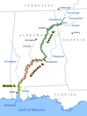
Alabama RiverDer Alabama River ist ein Fluss im US-Bundesstaat Alabama. Er entsteht durch den Zusammenfluss des Coosa River mit dem Tallapoosa River ungefähr sechs Meilen von Montgomery entfernt. .. weiterlesen
Wilcox County (Alabama)Das Wilcox County ist ein County im Bundesstaat Alabama der Vereinigten Staaten. Der Verwaltungssitz ist Camden. .. weiterlesen


