Alabama River
| Alabama River | ||
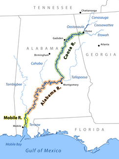
Übersicht von Mobile, Alabama und Coosa River | ||
| Daten | ||
| Gewässerkennzahl | US: 154961 | |
| Lage | Alabama (USA) | |
| Flusssystem | Mobile River | |
| Ursprung | Zusammenfluss des Coosa River mit dem Tallapoosa River 32° 30′ 5″ N, 86° 15′ 43″ W | |
| Zusammenfluss | mit dem Tombigbee River zum Mobile RiverKoordinaten: 31° 8′ 11″ N, 87° 56′ 38″ W 31° 8′ 11″ N, 87° 56′ 38″ W
| |
| Länge | 502 km | |
| Rechte Nebenflüsse | Cahaba River | |
| Mittelstädte | Montgomery | |
| Kleinstädte | Selma | |
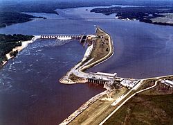
Millers Ferry Lock and Dam am Alabama River | ||
Der Alabama River ist ein Fluss im US-Bundesstaat Alabama. Er entsteht durch den Zusammenfluss des Coosa River mit dem Tallapoosa River ungefähr sechs Meilen von Montgomery entfernt.
Er verläuft westlich bis nach Selma, dann südwestlich, bis er sich etwa 50 km Luftlinie nördlich von Mobile mit dem Tombigbee River zum Mobile River vereinigt. Dieser mündet schließlich mit mehreren Armen – darunter dem Tensaw River, der den eigentlichen Mobile River 9 km unterhalb des Zusammenflusses von Alabama River und Tombigbee River verlässt – auf Höhe der Stadt Mobile in die Mobile Bay.
Die Breite des Flusses variiert zwischen 200 und 300 m, seine Tiefe liegt zwischen ein und zwei Metern. Er mäandert sehr stark entlang seines gesamten Verlaufs, was zu unterschiedlichen Längenangaben führt, je nachdem welches Messverfahren zur Anwendung kommt. Nach einer Messung der United States Geological Survey hat der Fluss eine Länge von 502 km. Die Messung der von einem Boot zurückgelegten Strecke liefert hingegen eine Länge von 676 km für den gesamten Flussverlauf.
Der Alabama River durchfließt reiche land- und forstwirtschaftliche Nutzflächen und ist durch Eisenbahnstrecken mit der Bergbauregion im zentralen Nordalabama verbunden.
Namensvarianten
Der Fluss besitzt mehrere Bezeichnungsvarianten:
- Alabama Fiume[1]
- Albama River[2]
- Halibama River[3]
- Moville River[4]
- Piache[5]
- Riviere des Alibamons[6]
- Río de Mobila[7]
Siehe auch
Einzelnachweise
- ↑ Fite, Emerson D., and Archibald Freeman. A Book of Old Maps. New York: Arno Press, 1926. Reprint, 1969. Delineates American history from the time of the Vikings to the end of the American Revolution. Each map is excellently annotated. p277
- ↑ Swift, Michael. Historical Maps of North America. London: PRC Publishing, 2001. Contains maps from the Public Records Office. p55
- ↑ Swift, Michael. Historical Maps of North America. London: PRC Publishing, 2001. Contains maps from the Public Records Office. p69
- ↑ Swift, Michael. Historical Maps of North America. London: PRC Publishing, 2001. Contains maps from the Public Records Office. p64
- ↑ Weddle, Robert S. Spanish Sea: The Gulf of Mexico in North American Discovery, 1500 1685. College Station, Texas: Texas A&M University Press, 1985. p268
- ↑ Foscue, Virginia. Place Names in Alabama. Tuscaloosa, Alabama : University of Alabama Press, 1989. p7
- ↑ Weddle, Robert S. Spanish Sea: The Gulf of Mexico in North American Discovery, 1500 1685. College Station, Texas: Texas A&M University Press, 1985. p9
Alabama River im Geographic Names Information System des United States Geological Survey
Auf dieser Seite verwendete Medien
Aerial view of Millers Ferry Lock and Dam on the Alabama River in Wilcox County, Alabama, USA. The lock and dam are located approximately 9.5 miles (15 km) northwest of Camden, Alabama. The dam impounds William “Bill” Dannelly Reservoir on the Alabama River, which backs up 105 miles (168 km) to the Robert F. Henry Lock and Dam upriver. The lock and dam were completed by the U.S. Army Corps of Engineers in 1970 for flood control, river navigation, and hydroelectric power generation. View is upriver to the north.
Autor/Urheber:
- Original: Pfly, using a base map template made with US Federal public domain GIS data;
- Version 3: John Lambert
Map showing the Mobile-Alabama-Coosa River for use on wikipedia pages about those rivers, which currently have poor or no maps. Also intended to show how the main river changes its name several times. Style inspired by the Commons image "Rhein-Karte.png". Revised earlier version to make tones darker. Revised to correct the position of Rome, Georgia.


