BogoslofIsland
Autor/Urheber:
T. Keith, U.S. Geological Survey
Größe:
1024 x 654 Pixel (140596 Bytes)
Beschreibung:
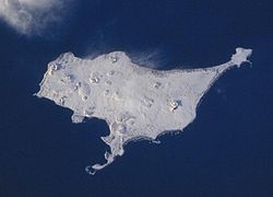
Aerial view, looking south, of Bogoslof Island, which is the summit of a largely submarine stratovolcano located in the Bering Sea 50 km (31 mi) behind the main Aleutian volcanic arc. The island is about 1.5x0.6 km (1x.4 mi) and, due to energetic wave action and frequent eruptive activity, it has changed shape dramatically since first mapped in the late 1700s. Its most recent eruption, in 1992, produced the conical, rubbly lava dome (150 m [492 ft] high)and offshore spire at bottom center.
Weitere Informationen zur Lizenz des Bildes finden Sie hier. Letzte Aktualisierung: Fri, 29 Sep 2023 10:16:15 GMT
Relevante Bilder
Relevante Artikel
Bogoslof Island
Bogoslof Island ist eine kleine unbewohnte Vulkaninsel der Fox Islands, die zu den Aleuten gehören. Das bis 2016 etwa 1,4 km lange und 0,288 km² große Eiland liegt nördlich von Umnak.
.. weiterlesen
Liste der National Natural Landmarks in Alaska
Die Liste der National Natural Landmarks in Alaska führt alle geologischen und ökologischen Objekte im US-amerikanischen Bundesstaat Alaska auf, die zu National Natural Landmarks erklärt wurden.
.. weiterlesen
Liste von Vulkanen in den Vereinigten Staaten
Dies ist eine Liste von Vulkanen in den USA, die während des Quartärs mindestens einmal aktiv waren.
.. weiterlesen

