Wildfires in southwest France ESA24375606

Autor/Urheber:
European Space Agency
Shortlink:
Quelle:
Größe:
1920 x 1920 Pixel (5638254 Bytes)
Beschreibung:
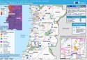
With searing temperatures and a string of record highs being smashed across western Europe, the current heatwave is all too apparent. Extreme heat warnings have been issued in several countries including France, Spain and Portugal, and deadly wildfires have forced thousands to flee their homes. This animation is an example of how the crisis is being viewed by satellites orbiting Earth. Using data from the Copernicus Sentinel-2 mission, it shows fires and burn scars near the town of Cazaux in the southern Gironde region in France.
The animation comprises images acquired on 12 July before the fires broke out and images acquired on 17 July when the fires were active. The difference is clear to see. Copernicus Sentinel-2 carries an innovative wide swath high-resolution multispectral imager with 13 spectral bands for a new perspective of our land and vegetation. Its shortwave infrared channel was used to highlight heat from the wildfire.
Read full story: Feeling the heat from space
Lizenz:
Attribution
Credit:
Bild teilen:


Relevante Bilder
.jpg)


.jpg)

(c) Drought conditions in Kent by Stephen Craven, CC BY-SA 2.0

_(cropped).jpg)


(c) Foto: Axel Hindemith, CC BY-SA 3.0


(c) Foto: Axel Hindemith, CC BY-SA 3.0


.jpg)
(c) Alan Hughes, CC BY-SA 2.0


(c) Peter Trimming, CC BY-SA 2.0


Relevante Artikel
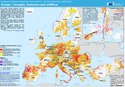
Dürre und Hitze in Europa 2022Die Dürre und Hitze in Europa 2022 war ein Wetterphänomen des Jahres 2022, das von unterdurchschnittlichen Regenmengen (Dürre) und überdurchschnittlichen Temperaturen geprägt wurde. Betroffen waren weite Teile Europas, insbesondere Süd-, West- und Mitteleuropa. Bereits Mitte Juli galt auf der Hälfte der Fläche der EU eine Dürrewarnung, für 15 % der EU-Fläche galt die rote Alarmstufe. Anschließend verschlechterte sich die Situation weiter. .. weiterlesen