Wax Lake Delta
Autor/Urheber:
National Center for Earth-surface Dynamics
Shortlink:
Quelle:
Größe:
292 x 256 Pixel (85875 Bytes)
Beschreibung:
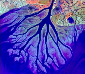
The Wax Lake Delta was formed by the deposition of sediment from a shipping canal off of the Atchafalaya River. The channel was routed through Wax Lake, which quickly filled with sediment. After Wax Lake filled, the sediment from the canal deposited offshore and created the delta.
Kommentar zur Lizenz:
![]() |
This image is a work of a National Science Foundation employee, taken or made as part of that person's official duties. As a work of the U.S. federal government, the image is in the public domain. | ![]() |
Lizenz:
Public domain
Credit:
National Center for Earth-surface Dynamics; http://www.nced.umn.edu/printview/Field_Site_Wax_Lake_Delta
Relevante Bilder
![](https://upload.wikimedia.org/wikipedia/commons/thumb/a/aa/Karte_der_Bauwerke_des_Deltaprojekts.png/250px-Karte_der_Bauwerke_des_Deltaprojekts.png)
![](https://upload.wikimedia.org/wikipedia/commons/thumb/b/b4/River_Makarora_flows_into_Lake_Wanaka.jpg/250px-River_Makarora_flows_into_Lake_Wanaka.jpg)
![](https://upload.wikimedia.org/wikipedia/commons/thumb/a/ac/Blaeu_1645_-_Tractus_Rheni_et_Mosæ_totusq_Vahalis_a_Rhenoberca_Gorcomium_usque_cum_terris_adjacentibus.jpg/250px-Blaeu_1645_-_Tractus_Rheni_et_Mosæ_totusq_Vahalis_a_Rhenoberca_Gorcomium_usque_cum_terris_adjacentibus.jpg)
![](https://upload.wikimedia.org/wikipedia/commons/thumb/d/dc/Map_of_the_annual_average_discharge_of_Rhine_and_Maas_2000-2011_%28DE%29.png/250px-Map_of_the_annual_average_discharge_of_Rhine_and_Maas_2000-2011_%28DE%29.png)
![](https://upload.wikimedia.org/wikipedia/commons/thumb/6/65/The_Netherlands_compared_to_sealevel.png/125px-The_Netherlands_compared_to_sealevel.png)
![](https://upload.wikimedia.org/wikipedia/commons/thumb/7/78/1580_Zelandicarum_v_Deventer.jpg/250px-1580_Zelandicarum_v_Deventer.jpg)
![](https://upload.wikimedia.org/wikipedia/commons/thumb/9/98/Eemien_NL_-_Paleogeography-3.jpg/125px-Eemien_NL_-_Paleogeography-3.jpg)
![](https://upload.wikimedia.org/wikipedia/commons/thumb/1/17/Map_provinces_Netherlands-de.svg/125px-Map_provinces_Netherlands-de.svg.png)
![](https://upload.wikimedia.org/wikipedia/commons/thumb/6/63/Seven_United_Netherlands_Janssonius_1658.jpg/250px-Seven_United_Netherlands_Janssonius_1658.jpg)
![](https://upload.wikimedia.org/wikipedia/commons/thumb/5/53/Flusssystemkarte_Rhein_02.jpg/125px-Flusssystemkarte_Rhein_02.jpg)
![](https://upload.wikimedia.org/wikipedia/commons/thumb/1/1c/Hendrick_Avercamp_-_A_Scene_on_the_Ice_-_WGA01076.jpg/250px-Hendrick_Avercamp_-_A_Scene_on_the_Ice_-_WGA01076.jpg)
![](https://upload.wikimedia.org/wikipedia/commons/thumb/3/3f/Beneeden_rivier_de_Maas.jpg/250px-Beneeden_rivier_de_Maas.jpg)
![](https://upload.wikimedia.org/wikipedia/commons/thumb/0/03/Arnhem_Nederrijn_ochtend_apr04.jpg/250px-Arnhem_Nederrijn_ochtend_apr04.jpg)
![](https://upload.wikimedia.org/wikipedia/commons/thumb/e/e0/Rhine%2C_Millingen%2C_Netherlands.jpg/250px-Rhine%2C_Millingen%2C_Netherlands.jpg)
![](https://upload.wikimedia.org/wikipedia/commons/thumb/5/50/Waal-Loevestein1.jpg/250px-Waal-Loevestein1.jpg)
![](https://upload.wikimedia.org/wikipedia/commons/thumb/7/7f/Europe_landforms_-_North_European_Plain.svg/250px-Europe_landforms_-_North_European_Plain.svg.png)
![](https://upload.wikimedia.org/wikipedia/commons/thumb/d/da/Roman_provinces_trajan_2.svg/250px-Roman_provinces_trajan_2.svg.png)
![](https://upload.wikimedia.org/wikipedia/commons/thumb/d/d6/Utrecht_5.11045E_52.08776N.jpg/250px-Utrecht_5.11045E_52.08776N.jpg)
![](https://upload.wikimedia.org/wikipedia/commons/thumb/a/aa/Provincies_relief_1440px.png/125px-Provincies_relief_1440px.png)
![](https://upload.wikimedia.org/wikipedia/commons/thumb/6/6f/Mouths_of_amazon_geocover_1990.png/250px-Mouths_of_amazon_geocover_1990.png)
![](https://upload.wikimedia.org/wikipedia/commons/thumb/8/81/Breskens_-_Westerschelde_1.jpg/250px-Breskens_-_Westerschelde_1.jpg)
![](https://upload.wikimedia.org/wikipedia/commons/thumb/9/97/Radiokarbon-Kalibrationskurve.png/250px-Radiokarbon-Kalibrationskurve.png)
![](https://upload.wikimedia.org/wikipedia/commons/thumb/2/2c/Maas_Delta1.jpg/125px-Maas_Delta1.jpg)
![](https://upload.wikimedia.org/wikipedia/commons/thumb/6/61/IJsselstein.IJssel.jpg/250px-IJsselstein.IJssel.jpg)
![](https://upload.wikimedia.org/wikipedia/commons/thumb/c/ca/3850vc_ex_leg_copy.jpg/125px-3850vc_ex_leg_copy.jpg)
![](https://upload.wikimedia.org/wikipedia/commons/thumb/f/ff/Rotterdam_4.45392E_51.91454N.jpg/250px-Rotterdam_4.45392E_51.91454N.jpg)
![](https://upload.wikimedia.org/wikipedia/commons/thumb/c/cb/Feuerstein_Geröll.jpg/250px-Feuerstein_Geröll.jpg)
![](https://upload.wikimedia.org/wikipedia/commons/thumb/9/99/Abschlussdeich_Blickrichtung_Nord.jpg/250px-Abschlussdeich_Blickrichtung_Nord.jpg)
(c) -jha-, CC BY-SA 3.0
![](https://upload.wikimedia.org/wikipedia/commons/thumb/c/c6/FaehreMaasMeeswijk-Berg.jpg/250px-FaehreMaasMeeswijk-Berg.jpg)
© Túrelio (via Wikimedia-Commons), 2006, CC BY-SA 2.5
![](https://upload.wikimedia.org/wikipedia/commons/thumb/6/67/2750vc_ex_leg_copy.jpg/125px-2750vc_ex_leg_copy.jpg)
![](https://upload.wikimedia.org/wikipedia/commons/thumb/f/f2/Crystalserenity02.jpg/250px-Crystalserenity02.jpg)
![](https://upload.wikimedia.org/wikipedia/commons/thumb/3/32/Niederrhein-Karte.png/250px-Niederrhein-Karte.png)
(c) Weetwat, CC BY-SA 3.0
![](https://upload.wikimedia.org/wikipedia/commons/thumb/e/e4/Schelde_4.25121E_51.26519N.jpg/250px-Schelde_4.25121E_51.26519N.jpg)
![](https://upload.wikimedia.org/wikipedia/commons/thumb/c/cb/IJssel_5.97133E_52.13786N.jpg/250px-IJssel_5.97133E_52.13786N.jpg)
![](https://upload.wikimedia.org/wikipedia/commons/thumb/5/58/IJmuiden_4.59609E_52.47021N.jpg/250px-IJmuiden_4.59609E_52.47021N.jpg)
![](https://upload.wikimedia.org/wikipedia/commons/thumb/a/aa/50nc_ex_leg_copy.jpg/125px-50nc_ex_leg_copy.jpg)
![](https://upload.wikimedia.org/wikipedia/commons/thumb/6/6c/500vc_ex_leg_copy.jpg/125px-500vc_ex_leg_copy.jpg)
![](https://upload.wikimedia.org/wikipedia/commons/thumb/9/99/Brielse_Maas1.png/400px-Brielse_Maas1.png)
Relevante Artikel
Rhein-Maas-DeltaDas Rhein-Maas-Delta ist der gemeinsame Mündungsbereich der Flüsse Rhein und Maas in Südholland in die Nordsee. Gelegentlich wird auch vom Rhein-Maas-Schelde-Delta gesprochen, obwohl die Mündung der Schelde im Südwesten deutlich von den ineinander verflochtenen Mündungsarmen des Rheins und der Maas im Nordosten unterscheidbar ist. .. weiterlesen