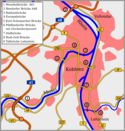
Vallendar in MYK


Autor/Urheber:
Hagar66 based on work of TUBS Gallery
Größe:
660 x 560 Pixel (234961 Bytes)
Beschreibung:
Deutsch (de): Lagekarte von Vallendar, Landkreis Mayen-Koblenz, Rheinland-Pfalz, Deutschland.
English (en): Locator map of Vallendar in District of Mayen-Koblenz, Rhineland-Palatinate, Germany.
français (fr): Plan de localisation de la municipalité Vallendar dans l'arrondissement de Mayen-Coblence dans Rhénanie-Palatinat, Allemagne.
hornjoserbsce (hsb): Poziciska karta gmejny Vallendar, Landkreis Mayen-Koblenz, Rheinland-Pfalz, Němska.
македонски (mk): Положбена карта на Vallendar во рамките на Landkreis Mayen-Koblenz, Rheinland-Pfalz, Германија.
Nederlands (nl): Detailkaart van Vallendar in de Landkreis Mayen-Koblenz, Rheinland-Pfalz, Duitsland.
Esperanto (eo): Situomapo de Vallendar en Landkreis Mayen-Koblenz, Rheinland-Pfalz, Germanio.
മലയാളം (ml): ജർമ്മനിയിലെ Rhineland-Palatinate, District of Mayen-Koblenz, Vallendar ഭൂപടസ്ഥാനം.

Lizenz:
Public domain
Credit:
Diese W3C-unbestimmte Vektorgrafik wurde mit Adobe Illustrator erstellt.
Bild teilen:
Facebook   Twitter   Pinterest   WhatsApp   Telegram   E-Mail
Weitere Informationen zur Lizenz des Bildes finden Sie hier. Letzte Aktualisierung: Mon, 14 Oct 2024 12:32:57 GMT

Relevante Bilder


Relevante Artikel

Vallendar

Die Stadt Vallendar ['fa.lɛn.ˌdaːɐ̯] ist ein Mittelzentrum im Landkreis Mayen-Koblenz in Rheinland-Pfalz. Sie ist Verwaltungssitz der Verbandsgemeinde Vallendar, der sie auch angehört. .. weiterlesen