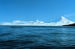
Unimak island
Autor/Urheber:
NASA
Shortlink:
Quelle:
Größe:
5240 x 5240 Pixel (11372959 Bytes)
Beschreibung:
Unimak Island, Alaska, United States - September 1992
Seen in this southwest-looking, low-oblique photograph is Unimak Island, Alaska, the largest island in the Aleutian chain. The major volcano on the island (snow-capped peak at the center of the photograph), Shishaldin, rises approximately 9400 feet (2860 meters) and has been active during the last 175 years, with several eruptions occurring recently. The volcano is known locally as "Smoking Moses." At the southwestern end of the island is the snow-capped Pogromni Volcano. The blue lake situated in a large volcanic caldera, which can be seen midway between the Pogromni and Shishaldin volcanoes, is the result of a now extinct volcano that collapsed.
Seen in this southwest-looking, low-oblique photograph is Unimak Island, Alaska, the largest island in the Aleutian chain. The major volcano on the island (snow-capped peak at the center of the photograph), Shishaldin, rises approximately 9400 feet (2860 meters) and has been active during the last 175 years, with several eruptions occurring recently. The volcano is known locally as "Smoking Moses." At the southwestern end of the island is the snow-capped Pogromni Volcano. The blue lake situated in a large volcanic caldera, which can be seen midway between the Pogromni and Shishaldin volcanoes, is the result of a now extinct volcano that collapsed.
Lizenz:
Public domain
Relevante Bilder
Relevante Artikel
Unimak IslandUnimak Island ist die größte und östlichste Insel der Aleuten. Sie liegt nur durch die an der engsten Stelle weniger als 700 Meter breite Isanotski Strait vom Festland beim Kabuch Point getrennt, die die Ikatan Bay im Süden mit der Bechevin Bay im Norden verbindet. Nach Südosten bildet Unimak die Ikatan-Halbinsel aus, die nur über eine weniger als 500 Meter breite Landzunge mit der Insel verbunden ist. Der äußerste Punkt dieser Halbinsel heißt Kap Pankof. .. weiterlesen


