USGS-MarsMap-sim3292-20140714-crop
July 14, 2014
http://pubs.usgs.gov/sim/3292/
---
NOTE: CROP by Dr. Dennis Bogdan (Drbogdan) - converted original PDF image (http://pubs.usgs.gov/sim/3292/pdf/sim3292_map.pdf) to PNG image via GIMP v2.8 & cropped with PSP v6.2 - July 22, 2014.
NOTE: FULL IMAGE => File:USGS-MarsMap-sim3292-20140714-full.png - derived from original PDF image at => http://pubs.usgs.gov/sim/3292/pdf/sim3292_map.pdf
ALSO RELATED:
- Video (00:56) - Planet Mars (USGS; 2014)
---
By Kenneth L. Tanaka, James A. Skinner, Jr., James M. Dohm, Rossman P. Irwin, III, Eric J. Kolb, Corey M. Fortezzo, Thomas Platz, Gregory G. Michael, and Trent M. Hare
ABSTRACT
This global geologic map of Mars, which records the distribution of geologic units and landforms on the planet's surface through time, is based on unprecedented variety, quality, and quantity of remotely sensed data acquired since the Viking Orbiters. These data have provided morphologic, topographic, spectral, thermophysical, radar sounding, and other observations for integration, analysis, and interpretation in support of geologic mapping. In particular, the precise topographic mapping now available has enabled consistent morphologic portrayal of the surface for global mapping (whereas previously used visual-range image bases were less effective, because they combined morphologic and albedo information and, locally, atmospheric haze). Also, thermal infrared image bases used for this map tended to be less affected by atmospheric haze and thus are reliable for analysis of surface morphology and texture at even higher resolution than the topographic products.Relevante Bilder
Relevante Artikel
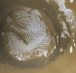
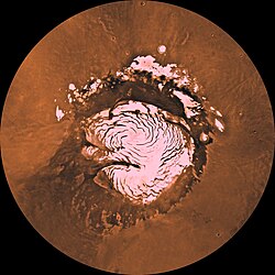
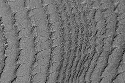
Polkappen des MarsDer Planet Mars besitzt an seinen beiden Polen auffällige, dauerhafte Eiskappen, die aus gefrorenem Kohlendioxid und Wassereis zusammengesetzt sind. Während der Wintersaison tauchen die Pole in vollständige Dunkelheit, die ein halbes Marsjahr (bzw. 343,5 Tage) andauert. Durch die extreme Kälte resublimieren 25–30 % des gasförmigen Kohlendioxids der dünnen Marsatmosphäre zu Trockeneis. Mit Rückkehr des Sonnenlichts im Sommerhalbjahr sublimiert das gefrorene CO2. Dabei entstehen enorme Windböen, die mit bis zu 400 km/h aus der Polregion herabwehen. Diese saisonbedingten Stürme erzeugen erdähnliche Frostbedingungen und transportieren sehr große Mengen an Staub und Wasserdampf. Durch die höhere Atmosphäre ziehen Cirruswolken. Im Jahr 2004 fotografierte der Rover Opportunity Wolken, die Wassereis enthielten. .. weiterlesen


