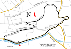
Track map for the Pau street circuit -- 2011
Autor/Urheber:
Attribution:
Das Bild ist mit 'Attribution Required' markiert, aber es wurden keine Informationen über die Attribution bereitgestellt. Vermutlich wurde bei Verwendung des MediaWiki-Templates für die CC-BY Lizenzen der Parameter für die Attribution weggelassen. Autoren und Urheber finden für die korrekte Verwendung der Templates hier ein Beispiel.
Shortlink:
Quelle:
Größe:
1424 x 983 Pixel (196579 Bytes)
Beschreibung:
Track map for use with Pau Grand Prix. This version shows the track as it should be in 2011.
Notes:
- This map has three text objects on paths. MediaWiki/RSVG has a bug causing it to hide all such objects. Hence, I the most recent version of this image should always have those objects converted into plain paths. If you need to edit the map, be sure to edit the previous version (compared to the current version). Then after making your changes:
- Upload it with the text objects on paths
- Convert each text object on a path back into a plain path
- Upload that version
- The text object labeled "Avenue Edouard VII" is actually a path. This is because Inkscape currently is unable to correctly put vertical text on paths. Converting it to a path let me use Inkscape's Bent Path LPE to shape the text to the road. In case the text of that object ever has to be edited, I backed it up in a hidden object at the same location.
Lizenz:
Relevante Bilder
Relevante Artikel
Circuit de Pau-VilleDer Circuit de Pau-Ville ist eine temporäre 2760 Meter lange Motorsport-Rennstrecke in der Innenstadt von Pau in Südwest-Frankreich, auf der der Grand Prix de Pau ausgetragen wird. Die Unterscheidung „Ville“ (Stadt) wurde hinzugefügt, seit in gut 20 km Entfernung von der Stadt die permanente Test- und Rennstrecke Circuit Pau-Arnos existiert. .. weiterlesen


