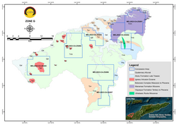
Timor-Leste Geological map of zone F
Autor/Urheber:
Autoridade Nacional do Petróleo e Minerais
Shortlink:
Quelle:
Größe:
2923 x 2068 Pixel (1016508 Bytes)
Beschreibung:
Zone F is located within the Atauro Island, the 14th municipality of Timor-Leste. This zone has a total estimated area of 116 km2 (indicated within the Zone F boundary). The lithology and process of the formation of the Atauro Island is different than the Timor Island as Atauro is part of inner volcanic arc of Banda Arc. The geology of the Atauro Island based on the reinterpreted map from KARVAK (2022) are mainly covered with three different type of volcanics, i.e. Manucoco, Tutonariana-Berau, and Atauro Volcanics, as well as Marine terraces (Figure 8). The Tutonariana-Berau Volcanics, which consist of breccia, tuffs and some lavas as in KARVAK (2022) corresponded to clinopyroxene-phyric basaltic andesite and limestone based on the Ely et al. (2011) geological map. The north-eastern side lithology which interpreted as the Atauro Volcanics (KARVAK 2022), corresponded with dacite (Ely et al. 2011).
Based on the previous studies there is an indication of metallic minerals such as gold, silver, and manganese (UN-ESCAP 2003), as well as copper (KARVAK 2022), and non-metallic mineral such as limestones and potential kaolin (UN-ESCAP 2003) within this zone. No detail studies have been carried out in the island to explore for metallic minerals, however as Atauro is part of the inner volcanic of Banda Arc, it is suggested that the mineralisation is most likely is hosted by epithermal style mineralization and also has potential for VMS type deposit as its neighbouring island, Wetar Island. The copper mineralisation observed within Atauro occurs as secondary minerals such as malachite associated with tuff (KARVAK 2022). Majority of these indicated mineralisation is associated with the volcanic rocks within the area (UN-ESCAP 2003; KARVAK 2022).
Lizenz:
Public domain
Credit:
Relevante Bilder
Relevante Artikel
Geographie OsttimorsDie Geographie Osttimors wird durch seine Lage im Übergang von Asien zu Australien geprägt. Osttimor ist das einzige Land Asiens, dessen Staatsgebiet komplett südlich des Äquators liegt. Das Territorium umfasst nicht nur die östliche Hälfte Timors, sondern auch die Exklave Oe-Cusse Ambeno, welche an der Nordküste des indonesischen Teils der Insel gelegen ist, sowie die beiden kleinen Inseln Atauro und Jaco. .. weiterlesen


