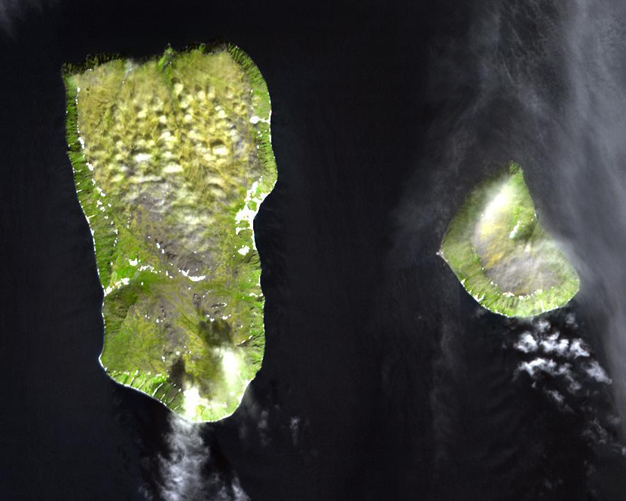
The Diomede Islands in the BeringSea (picture from space)
.jpg?uselang=de)
- Western: Russian island of Big Diomede, Imaqliq, Nunarbuk or Ratmanov Island
- Eastern: U.S. island of Little Diomede, in its native language Inaliq or Krusenstern Island (this is the island w:en:Sarah Palin was talking about when she said, "They're our next-door neighbors, and you can actually see Russia from land here in Alaska, from an island in Alaska.")
This file is in the public domain because it was created by NASA. NASA copyright policy states that "NASA material is not protected by copyright unless noted". (NASA copyright policy page or JPL Image Use Policy). This image does not contain a NASA logo.
- Image: diomede.jpg
- Text info: Diomede Islands, Bering Strait


Relevante Bilder


Relevante Artikel
Little Diomede IslandLittle Diomede Island, früher auch nach dem Admiral der russischen Flotte Adam Johann von Krusenstern Krusenstern Island genannt, ist eine zum US-Bundesstaat Alaska gehörende Insel und bildet mit der etwa 4 km westlich liegenden russischen Ratmanow-Insel und dem unbewohnten Fairway Rock die Gruppe der Diomedes-Inseln. .. weiterlesen
Ratmanow-InselDie Ratmanow-Insel, auch Große Diomedes-Insel genannt, bildet mit der etwa 4 km östlich liegenden Little Diomede Island und dem unbewohnten Fairway Rock die Gruppe der Diomedes-Inseln. Sie ist der östlichste Punkt Russlands. Das russische Festland im Westen ist 35,68 Kilometer entfernt. .. weiterlesen
Diomedes-InselnDie Diomedes-Inseln sind eine Inselgruppe in der Beringstraße. Sie besteht aus der westlichen Ratmanow-Insel und der östlich gelegenen Kleinen Diomedes-Insel. Zusätzlich zur amerikanisch-russischen Staatsgrenze verläuft zwischen den beiden Inseln auch die Internationale Datumsgrenze. Beide Inseln sind rund vier Kilometer voneinander entfernt. Gelegentlich zählt man den etwa 15 km südöstlich der Kleinen Diomedes-Insel gelegenen, unbewohnten Fairway-Felsen (USA) ebenfalls zur Inselgruppe. .. weiterlesen