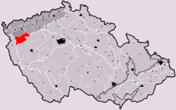
Tepelska vrchovina CZ I3C-2 subdivisions colour code
Autor/Urheber:
Shortlink:
Quelle:
Größe:
970 x 808 Pixel (73994 Bytes)
Beschreibung:
Poloha a členění geomorfologického celku Tepelská vrchovina na podkladové mapě územněsprávního členění pomezí okresů Karlovy Vary, Cheb, Tachov a Plzeň-sever.
-
Hercynský systém
-
Hercynská pohoří
- I Česká vysočina
- I3 (V) Krušnohorská subprovincie
- I3C (IIIC) Karlovarská vrchovina
- I3C-2 (IIIC2) Tepelská vrchovina (Tepler Hochland)
- I3C-2-A (IIIC2-A) Toužimská plošina (Theusinger Hochland)
- I3C-2-A-a (IIIC2-A-a) Útvinská plošina
- I3C-2-A-b (IIIC2-A-b) Mrázovská pahorkatina
- I3C-2-A-c (IIIC2-A-c) Mariánskolázeňská vrchovina
- I3C-2-B (IIIC2-B) Bezdružická vrchovina (Weseritzer Bergland)
- I3C-2-B-a (IIIC2-B-a) Michalohorská vrchovina
- I3C-2-B-b (IIIC2-B-b) Vidžínská vrchovina
- I3C-2-B-c (IIIC2-B-c) Hanovská pahorkatina
- I3C-2-B-d (IIIC2-B-d) Trhomenská vrchovina
- I3C-2-B-e (IIIC2-B-e) Krasíkovská vrchovina
- I3C-2-C (IIIC2-C) Žlutická vrchovina (Luditzer Bergland)
- I3C-2-C-a (IIIC2-C-a) Bochovská vrchovina
- I3C-2-C-b (IIIC2-C-b) Vladařská vrchovina
- I3C-2-A (IIIC2-A) Toužimská plošina (Theusinger Hochland)
- I3C-2 (IIIC2) Tepelská vrchovina (Tepler Hochland)
- I3C (IIIC) Karlovarská vrchovina
- I3 (V) Krušnohorská subprovincie
- I Česká vysočina
-
Hercynská pohoří
Kommentar zur Lizenz:
PD-self
Lizenz:
Public domain
Credit:
Eigenes Werk, based on File:Karlovy Vary District 2010 KV CZ.png and other related files by myself. Main sources of geomorphic subdivision information:
- Jaromír Demek et al. (1987): Hory a nížiny. Academia, Praha, 1987
- Portál veřejné správy České republiky
Relevante Bilder
Relevante Artikel
Tepler HochlandDas Tepler Hochland bildet eine geomorphologische Einheit in Tschechien. .. weiterlesen

