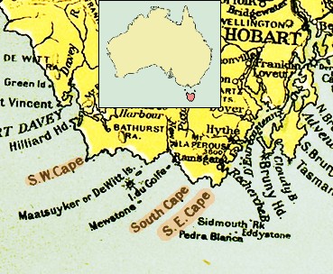
Tasmania southern coast 1916
Autor/Urheber:
- map of Tasmania's coast: for original author see source; uploader of original map (see "other versions") was Astrokey44;
- inserted locator map of Tasmania: author was Martyman at the English Wikipedia; uploader to the Wikimedia Commons was Snowdog;
- combined and edited by: Ibn Battuta
Attribution:
Das Bild ist mit 'Attribution Required' markiert, aber es wurden keine Informationen über die Attribution bereitgestellt. Vermutlich wurde bei Verwendung des MediaWiki-Templates für die CC-BY Lizenzen der Parameter für die Attribution weggelassen. Autoren und Urheber finden für die korrekte Verwendung der Templates hier ein Beispiel.
Shortlink:
Quelle:
Größe:
369 x 304 Pixel (70474 Bytes)
Beschreibung:
Southern Coast of Tasmania.
From the map "Commonwealth of Australia", published with the Official Year Book of the Commonwealth of Australia, Melbourne: McCarron, Bird and Co., 1916.
Lizenz:
Credit:
map "Commonwealth of Australia", published with the Official Year Book of the Commonwealth of Australia, Melbourne: McCarron, Bird and Co., 1916.
Bild teilen:


Relevante Bilder


Relevante Artikel
SüdostkapDas Südostkap ist der südlichste Punkt von Tasmanien und damit zugleich der südlichste Punkt des australischen und tasmanischen Festlandes gemeinsam. .. weiterlesen