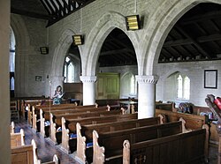
St Stephen, Lympne 1
Autor/Urheber:
Shortlink:
Quelle:
Größe:
2048 x 1536 Pixel (972632 Bytes)
Beschreibung:
St Stephen, Lympne
Lizenz:
Relevante Bilder
![](https://upload.wikimedia.org/wikipedia/commons/thumb/a/a6/St_Stephen%2C_Lympne%2C_Kent_-_geograph.org.uk_-_326054.jpg/250px-St_Stephen%2C_Lympne%2C_Kent_-_geograph.org.uk_-_326054.jpg)
(c) John Salmon, CC BY-SA 2.0
![](https://upload.wikimedia.org/wikipedia/commons/thumb/6/6e/St_John_the_Baptist%2C_Bishopsteignton%2C_Devon_-_East_end_-_geograph.org.uk_-_1727532.jpg/250px-St_John_the_Baptist%2C_Bishopsteignton%2C_Devon_-_East_end_-_geograph.org.uk_-_1727532.jpg)
(c) John Salmon, CC BY-SA 2.0
![](https://upload.wikimedia.org/wikipedia/commons/thumb/6/6a/Interior_of_the_Church_of_St_Michael_^_St_James%2C_Linby_cum_Papplewick_-_geograph.org.uk_-_4331498.jpg/250px-Interior_of_the_Church_of_St_Michael_^_St_James%2C_Linby_cum_Papplewick_-_geograph.org.uk_-_4331498.jpg)
(c) Interior of the Church of St Michael & St James, Linby cum Papplewick by Dave Hitchborne, CC BY-SA 2.0
![](https://upload.wikimedia.org/wikipedia/commons/thumb/f/fc/St_John_the_Baptist%2C_Higher_Ashton%2C_Devon_-_East_end_-_geograph.org.uk_-_1731740.jpg/250px-St_John_the_Baptist%2C_Higher_Ashton%2C_Devon_-_East_end_-_geograph.org.uk_-_1731740.jpg)
(c) John Salmon, CC BY-SA 2.0
![](https://upload.wikimedia.org/wikipedia/commons/thumb/3/30/St_John_the_Baptist%2C_Higher_Ashton%2C_Devon_-_geograph.org.uk_-_1731733.jpg/125px-St_John_the_Baptist%2C_Higher_Ashton%2C_Devon_-_geograph.org.uk_-_1731733.jpg)
(c) John Salmon, CC BY-SA 2.0
![](https://upload.wikimedia.org/wikipedia/commons/thumb/0/07/188_of_%27The_History_of_Dorchester%2C_Oxfordshire-_British_earthworks-Roman_Camp-Bishopric._And_the_architectural_history_of_the_Church%2C_compiled_from_the_best_authorities._With_a_general_introduction_by_J._H._P%27_%2811154061806%29.jpg/250px-thumbnail.jpg)
![](https://upload.wikimedia.org/wikipedia/commons/thumb/7/7e/St_Peter%2C_Steeple_Aston%2C_Oxon_-_East_end_-_geograph.org.uk_-_1609703.jpg/250px-St_Peter%2C_Steeple_Aston%2C_Oxon_-_East_end_-_geograph.org.uk_-_1609703.jpg)
(c) John Salmon, CC BY-SA 2.0
![](https://upload.wikimedia.org/wikipedia/commons/thumb/c/c4/Eglwys_Santes_Eurgain_a_Sant_Pedr%2C_Llaneurgain_-_Church_of_St_Eurgain_and_St_Paul%2C_Northop%2C_Flintshire_Cymru_Wales_95.jpg/250px-Eglwys_Santes_Eurgain_a_Sant_Pedr%2C_Llaneurgain_-_Church_of_St_Eurgain_and_St_Paul%2C_Northop%2C_Flintshire_Cymru_Wales_95.jpg)
![](https://upload.wikimedia.org/wikipedia/commons/thumb/7/73/St._Bartholomew%27s_church%2C_Yealmpton_-_interior_%282%29_-_geograph.org.uk_-_1420138.jpg/125px-St._Bartholomew%27s_church%2C_Yealmpton_-_interior_%282%29_-_geograph.org.uk_-_1420138.jpg)
(c) Ruth Sharville, CC BY-SA 2.0
![](https://upload.wikimedia.org/wikipedia/commons/thumb/8/83/St_Paul%2C_Deptford_High_Street%2C_London_SE8_-_West_end-geograph-2076186-by-John-Salmon.jpg/250px-St_Paul%2C_Deptford_High_Street%2C_London_SE8_-_West_end-geograph-2076186-by-John-Salmon.jpg)
(c) John Salmon, CC BY-SA 2.0
![](https://upload.wikimedia.org/wikipedia/commons/thumb/0/0c/St._Bartholomew%27s_church%2C_Yealmpton_-_interior_-_geograph.org.uk_-_1420114.jpg/250px-St._Bartholomew%27s_church%2C_Yealmpton_-_interior_-_geograph.org.uk_-_1420114.jpg)
(c) Ruth Sharville, CC BY-SA 2.0
![](https://upload.wikimedia.org/wikipedia/commons/thumb/7/75/St_Martin_and_St_Mary%2C_Chudleigh%2C_Devon_-_East_end_-_geograph.org.uk_-_1729823.jpg/125px-St_Martin_and_St_Mary%2C_Chudleigh%2C_Devon_-_East_end_-_geograph.org.uk_-_1729823.jpg)
(c) John Salmon, CC BY-SA 2.0
![](https://upload.wikimedia.org/wikipedia/commons/thumb/0/0a/St_Stephens_N_Mundham_-_geograph.org.uk_-_22639.jpg/250px-St_Stephens_N_Mundham_-_geograph.org.uk_-_22639.jpg)
(c) Chris Shaw, CC BY-SA 2.0
![](https://upload.wikimedia.org/wikipedia/commons/thumb/5/5e/Yarnton%2C_St._Bartholomew%27s_Church%2C_The_nave_with_its_unusual_chancel_arch_and_c15th_painting_-_geograph.org.uk_-_5196508.jpg/250px-Yarnton%2C_St._Bartholomew%27s_Church%2C_The_nave_with_its_unusual_chancel_arch_and_c15th_painting_-_geograph.org.uk_-_5196508.jpg)
(c) Yarnton, St. Bartholomew's Church: The nave with its unusual chancel arch and c15th painting by Michael Garlick, CC BY-SA 2.0
![](https://upload.wikimedia.org/wikipedia/commons/thumb/c/c8/St_Peter%2C_Steeple_Aston%2C_Oxon_-_geograph.org.uk_-_1609642.jpg/250px-St_Peter%2C_Steeple_Aston%2C_Oxon_-_geograph.org.uk_-_1609642.jpg)
(c) John Salmon, CC BY-SA 2.0
![](https://upload.wikimedia.org/wikipedia/commons/thumb/f/f6/Linton_St_Michael_and_All_Saints%2C_Linton%2C_Interior_GeoUK931477.jpg/250px-Linton_St_Michael_and_All_Saints%2C_Linton%2C_Interior_GeoUK931477.jpg)
(c) Alexander P Kapp, CC BY-SA 2.0
![](https://upload.wikimedia.org/wikipedia/commons/thumb/9/9f/St_Mary%27s_church%2C_Lympstone_-_geograph.org.uk_-_264515.jpg/125px-St_Mary%27s_church%2C_Lympstone_-_geograph.org.uk_-_264515.jpg)
(c) Derek Harper, CC BY-SA 2.0
![](https://upload.wikimedia.org/wikipedia/commons/thumb/e/ed/St_John_the_Baptist_Church%2C_Layer-de-la-Haye%2C_Essex_%28geograph_2013175%29.jpg/250px-St_John_the_Baptist_Church%2C_Layer-de-la-Haye%2C_Essex_%28geograph_2013175%29.jpg)
(c) Peter Stack, CC BY-SA 2.0
![](https://upload.wikimedia.org/wikipedia/commons/thumb/1/16/Clanfield_St_Stephen_nave_arcade_aisle_GeoUK_2518388.jpg/250px-Clanfield_St_Stephen_nave_arcade_aisle_GeoUK_2518388.jpg)
![](https://upload.wikimedia.org/wikipedia/commons/thumb/2/2e/Interior%2C_Church_of_St_Peter_and_St_Paul%2C_Broadhempston_-_geograph.org.uk_-_946113.jpg/125px-Interior%2C_Church_of_St_Peter_and_St_Paul%2C_Broadhempston_-_geograph.org.uk_-_946113.jpg)
(c) Trish Steel, CC BY-SA 2.0
![](https://upload.wikimedia.org/wikipedia/commons/thumb/d/d4/Eglwys_Sant_Trillo_-_St_Trillo%27s_Church%2C_Llandrillo_yn_Rhos%2C_Conwy%2C_Wales_24.jpg/250px-Eglwys_Sant_Trillo_-_St_Trillo%27s_Church%2C_Llandrillo_yn_Rhos%2C_Conwy%2C_Wales_24.jpg)
![](https://upload.wikimedia.org/wikipedia/commons/thumb/4/49/St_Philip%27s_Cathedral%2C_Birmingham%2C_February_2023_11.jpg/250px-St_Philip%27s_Cathedral%2C_Birmingham%2C_February_2023_11.jpg)
![](https://upload.wikimedia.org/wikipedia/commons/thumb/d/d3/Nave_of_the_Church_of_Saint_Mary_the_Blessed_Virgin%2C_Addington_%28West-Facing_View_-_01%29.jpg/250px-Nave_of_the_Church_of_Saint_Mary_the_Blessed_Virgin%2C_Addington_%28West-Facing_View_-_01%29.jpg)
![](https://upload.wikimedia.org/wikipedia/commons/thumb/e/e9/South_Aisle_of_the_Church_of_Saint_Mary_and_Saint_Peter%2C_Wennington_%2801%29.jpg/250px-South_Aisle_of_the_Church_of_Saint_Mary_and_Saint_Peter%2C_Wennington_%2801%29.jpg)
![](https://upload.wikimedia.org/wikipedia/commons/thumb/b/b7/St_Bartholomew%2C_Otford%2C_nave_01.jpg/250px-St_Bartholomew%2C_Otford%2C_nave_01.jpg)
![](https://upload.wikimedia.org/wikipedia/commons/thumb/f/fa/Hagley%2C_St_John_the_Baptist_-_interior%2C_nave_%28looking_towards_east%29_-_photo_3.jpg/250px-Hagley%2C_St_John_the_Baptist_-_interior%2C_nave_%28looking_towards_east%29_-_photo_3.jpg)
![](https://upload.wikimedia.org/wikipedia/commons/thumb/4/42/Church_of_St_Peter_and_St_Paul_Upper_Hardres_Kent_England_from_the_northwest.jpg/250px-Church_of_St_Peter_and_St_Paul_Upper_Hardres_Kent_England_from_the_northwest.jpg)
![](https://upload.wikimedia.org/wikipedia/commons/thumb/c/cf/St_Chad%27s_Church%2C_Holt%2C_Wrexham%2C_Cymru%2C_Wales_95.jpg/125px-St_Chad%27s_Church%2C_Holt%2C_Wrexham%2C_Cymru%2C_Wales_95.jpg)
![](https://upload.wikimedia.org/wikipedia/commons/thumb/2/26/Great_Yarmouth_Minster%2C_3_June_2021%2C_From_roughly_north_of_it._Image_1.jpg/250px-Great_Yarmouth_Minster%2C_3_June_2021%2C_From_roughly_north_of_it._Image_1.jpg)
Relevante Artikel
Liste der Hallenkirchen im Vereinigten Königreich▶ Liste(n) der Hallenkirchen – Übersicht .. weiterlesen