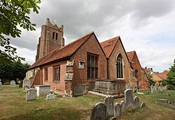
StDunstanFrinsted
(c) Penny Mayes, CC BY-SA 2.0
Autor/Urheber:
Shortlink:
Quelle:
Größe:
640 x 480 Pixel (169739 Bytes)
Beschreibung:
St Dunstan's Church, Frinsted, Kent
Kommentar zur Lizenz:
Creative Commons Attribution Share-alike license 2.0
Lizenz:
Credit:
From geograph.org.uk
Relevante Bilder
![](https://upload.wikimedia.org/wikipedia/commons/thumb/1/1c/St._Dunstans%2C_Frinsted_%28geograph_5016881%29.jpg/250px-St._Dunstans%2C_Frinsted_%28geograph_5016881%29.jpg)
(c) Chris Whippet / St. Dunstans, Frinsted, CC BY-SA 2.0
![](https://upload.wikimedia.org/wikipedia/commons/thumb/c/ce/Interior%2C_St_Dunstan%27s_church%2C_West_Peckham_-_geograph.org.uk_-_3839186.jpg/250px-Interior%2C_St_Dunstan%27s_church%2C_West_Peckham_-_geograph.org.uk_-_3839186.jpg)
(c) Interior, St Dunstan's church, West Peckham by Julian P Guffogg, CC BY-SA 2.0
![](https://upload.wikimedia.org/wikipedia/commons/thumb/3/38/St_John_the_Baptist%2C_Wittersham_-_interior_looking_south-east_-_geograph.org.uk_-_3963492.jpg/250px-St_John_the_Baptist%2C_Wittersham_-_interior_looking_south-east_-_geograph.org.uk_-_3963492.jpg)
(c) St John the Baptist, Wittersham - interior looking south-east by David Kemp, CC BY-SA 2.0
![](https://upload.wikimedia.org/wikipedia/commons/thumb/9/96/St_Dunstan%27s_church%2C_West_Peckham_-_geograph.org.uk_-_3839102.jpg/250px-St_Dunstan%27s_church%2C_West_Peckham_-_geograph.org.uk_-_3839102.jpg)
(c) St Dunstan's church, West Peckham by Julian P Guffogg, CC BY-SA 2.0
![](https://upload.wikimedia.org/wikipedia/commons/thumb/8/83/St_Peter_and_St_Paul_Church%2C_Ospringe%2C_Kent_-_East_end.jpg/250px-St_Peter_and_St_Paul_Church%2C_Ospringe%2C_Kent_-_East_end.jpg)
(c) John Salmon, CC BY-SA 2.0
![](https://upload.wikimedia.org/wikipedia/commons/thumb/8/8c/St_Illtud%2C_Llantwit_Major%2C_Glamorgan%2C_Wales_-_West_end_-_geograph.org.uk_-_544792.jpg/125px-St_Illtud%2C_Llantwit_Major%2C_Glamorgan%2C_Wales_-_West_end_-_geograph.org.uk_-_544792.jpg)
(c) John Salmon, CC BY-SA 2.0
![](https://upload.wikimedia.org/wikipedia/commons/thumb/d/da/St_Peter_and_St_Paul%2C_Ermington_-_East_end_-_geograph.org.uk_-_1724546.jpg/250px-St_Peter_and_St_Paul%2C_Ermington_-_East_end_-_geograph.org.uk_-_1724546.jpg)
(c) John Salmon, CC BY-SA 2.0
![](https://upload.wikimedia.org/wikipedia/commons/thumb/7/75/St_Martin_and_St_Mary%2C_Chudleigh%2C_Devon_-_East_end_-_geograph.org.uk_-_1729823.jpg/125px-St_Martin_and_St_Mary%2C_Chudleigh%2C_Devon_-_East_end_-_geograph.org.uk_-_1729823.jpg)
(c) John Salmon, CC BY-SA 2.0
![](https://upload.wikimedia.org/wikipedia/commons/thumb/0/07/188_of_%27The_History_of_Dorchester%2C_Oxfordshire-_British_earthworks-Roman_Camp-Bishopric._And_the_architectural_history_of_the_Church%2C_compiled_from_the_best_authorities._With_a_general_introduction_by_J._H._P%27_%2811154061806%29.jpg/250px-thumbnail.jpg)
![](https://upload.wikimedia.org/wikipedia/commons/thumb/8/87/St_Martin%2C_Cheriton%2C_Kent_-_East_end_-_geograph.org.uk_-_326035.jpg/125px-St_Martin%2C_Cheriton%2C_Kent_-_East_end_-_geograph.org.uk_-_326035.jpg)
(c) John Salmon, CC BY-SA 2.0
![](https://upload.wikimedia.org/wikipedia/commons/thumb/9/94/St_Anthony_of_Panniers%2C_Alkham%2C_Kent_-_East_end_-_geograph.org.uk_-_325587.jpg/125px-St_Anthony_of_Panniers%2C_Alkham%2C_Kent_-_East_end_-_geograph.org.uk_-_325587.jpg)
(c) John Salmon, CC BY-SA 2.0
![](https://upload.wikimedia.org/wikipedia/commons/thumb/0/09/St_Peter_and_St_Paul%2C_Aylesford%2C_Kent_-_East_end_-_geograph.org.uk_-_321865.jpg/250px-St_Peter_and_St_Paul%2C_Aylesford%2C_Kent_-_East_end_-_geograph.org.uk_-_321865.jpg)
(c) John Salmon, CC BY-SA 2.0
![](https://upload.wikimedia.org/wikipedia/commons/thumb/a/aa/St_Mary%27s_Church%2C_Kennington%2C_Kent_-_East_end_-_geograph.org.uk_-_811708.jpg/250px-St_Mary%27s_Church%2C_Kennington%2C_Kent_-_East_end_-_geograph.org.uk_-_811708.jpg)
(c) John Salmon, CC BY-SA 2.0
![](https://upload.wikimedia.org/wikipedia/commons/thumb/2/23/St_Peter_and_St_Paul%2C_Kimpton%2C_Herts_-_East_end_-_geograph.org.uk_-_374426.jpg/250px-St_Peter_and_St_Paul%2C_Kimpton%2C_Herts_-_East_end_-_geograph.org.uk_-_374426.jpg)
(c) John Salmon, CC BY-SA 2.0
![](https://upload.wikimedia.org/wikipedia/commons/thumb/3/36/St_Catherine_and_St_Paul%2C_Hoddesdon%2C_Herts_-_East_end_-_geograph.org.uk_-_1356397.jpg/250px-St_Catherine_and_St_Paul%2C_Hoddesdon%2C_Herts_-_East_end_-_geograph.org.uk_-_1356397.jpg)
(c) John Salmon, CC BY-SA 2.0
![](https://upload.wikimedia.org/wikipedia/commons/thumb/d/d5/St_Peter%27s_Church%2C_Heversham%2C_Cumbria_-_East_end_-_geograph.org.uk_-_937655.jpg/250px-St_Peter%27s_Church%2C_Heversham%2C_Cumbria_-_East_end_-_geograph.org.uk_-_937655.jpg)
(c) John Salmon, CC BY-SA 2.0
![](https://upload.wikimedia.org/wikipedia/commons/thumb/c/c4/Eglwys_Santes_Eurgain_a_Sant_Pedr%2C_Llaneurgain_-_Church_of_St_Eurgain_and_St_Paul%2C_Northop%2C_Flintshire_Cymru_Wales_95.jpg/250px-Eglwys_Santes_Eurgain_a_Sant_Pedr%2C_Llaneurgain_-_Church_of_St_Eurgain_and_St_Paul%2C_Northop%2C_Flintshire_Cymru_Wales_95.jpg)
![](https://upload.wikimedia.org/wikipedia/commons/thumb/1/15/St_James_the_Greater%2C_Dadlington_-_East_end_-_geograph.org.uk_-_4470628.jpg/250px-St_James_the_Greater%2C_Dadlington_-_East_end_-_geograph.org.uk_-_4470628.jpg)
(c) St James the Greater, Dadlington - East end by John Salmon, CC BY-SA 2.0
![](https://upload.wikimedia.org/wikipedia/commons/thumb/d/d3/St_Mary_the_Virgin%2C_North_Stifford_-_East_end_%28geograph_2657471%29.jpg/250px-St_Mary_the_Virgin%2C_North_Stifford_-_East_end_%28geograph_2657471%29.jpg)
(c) John Salmon, CC BY-SA 2.0
![](https://upload.wikimedia.org/wikipedia/commons/thumb/e/e5/St_Edmund_%26_St_Mary%2C_Ingatestone%2C_Essex_%28geograph_2018608%29.jpg/250px-St_Edmund_%26_St_Mary%2C_Ingatestone%2C_Essex_%28geograph_2018608%29.jpg)
(c) John Salmon, CC BY-SA 2.0
![](https://upload.wikimedia.org/wikipedia/commons/thumb/0/0d/St_Peter_%26_St_Paul%2C_Horndon_on_the_Hill_-_East_end_%28geograph_1890100%29.jpg/250px-St_Peter_%26_St_Paul%2C_Horndon_on_the_Hill_-_East_end_%28geograph_1890100%29.jpg)
(c) John Salmon, CC BY-SA 2.0
![](https://upload.wikimedia.org/wikipedia/commons/thumb/7/7e/St_Mary%2C_Neasden_Lane%2C_Church_End_-_East_end_-_geograph.org.uk_-_3373936.jpg/250px-St_Mary%2C_Neasden_Lane%2C_Church_End_-_East_end_-_geograph.org.uk_-_3373936.jpg)
(c) St Mary, Neasden Lane, Church End - East end by John Salmon, CC BY-SA 2.0
![](https://upload.wikimedia.org/wikipedia/commons/thumb/6/6e/St_John_the_Baptist%2C_Bishopsteignton%2C_Devon_-_East_end_-_geograph.org.uk_-_1727532.jpg/250px-St_John_the_Baptist%2C_Bishopsteignton%2C_Devon_-_East_end_-_geograph.org.uk_-_1727532.jpg)
(c) John Salmon, CC BY-SA 2.0
![](https://upload.wikimedia.org/wikipedia/commons/thumb/0/03/St_Dicen%2C_Bradninch%2C_Devon_-_East_end_-_geograph.org.uk_-_1726163.jpg/250px-St_Dicen%2C_Bradninch%2C_Devon_-_East_end_-_geograph.org.uk_-_1726163.jpg)
(c) John Salmon, CC BY-SA 2.0
![](https://upload.wikimedia.org/wikipedia/commons/thumb/4/42/St_Andrew%2C_East_Allington_-_East_end_-_geograph.org.uk_-_1724609.jpg/250px-St_Andrew%2C_East_Allington_-_East_end_-_geograph.org.uk_-_1724609.jpg)
(c) John Salmon, CC BY-SA 2.0
![](https://upload.wikimedia.org/wikipedia/commons/thumb/3/35/Church_of_St_John_Baptist%2C_Rectory_Lane%2C_Instow_-_geograph.org.uk_-_766840.jpg/250px-Church_of_St_John_Baptist%2C_Rectory_Lane%2C_Instow_-_geograph.org.uk_-_766840.jpg)
(c) Roger A Smith, CC BY-SA 2.0
![](https://upload.wikimedia.org/wikipedia/commons/thumb/f/fc/The_church_of_SS_Peter_and_Paul_in_Wangford_-_view_west_-_geograph.org.uk_-_2078325.jpg/250px-The_church_of_SS_Peter_and_Paul_in_Wangford_-_view_west_-_geograph.org.uk_-_2078325.jpg)
(c) The church of SS Peter and Paul in Wangford - view west by Evelyn Simak, CC BY-SA 2.0
![](https://upload.wikimedia.org/wikipedia/commons/thumb/c/c1/St_Andrew%27s_church_in_Westhall_-_view_east_-_geograph.org.uk_-_2117273.jpg/250px-St_Andrew%27s_church_in_Westhall_-_view_east_-_geograph.org.uk_-_2117273.jpg)
(c) St Andrew's church in Westhall - view east by Evelyn Simak, CC BY-SA 2.0
![](https://upload.wikimedia.org/wikipedia/commons/thumb/5/52/St_Thomas_the_Apostle%2C_Navestock_-_East_end_%28geograph_2444516%29.jpg/250px-St_Thomas_the_Apostle%2C_Navestock_-_East_end_%28geograph_2444516%29.jpg)
(c) John Salmon, CC BY-SA 2.0
![](https://upload.wikimedia.org/wikipedia/commons/thumb/c/c5/St_Peter_and_St_Paul%2C_Edenbridge%2C_Kent_01.jpg/250px-St_Peter_and_St_Paul%2C_Edenbridge%2C_Kent_01.jpg)
(c) John Salmon, CC BY-SA 2.0
![](https://upload.wikimedia.org/wikipedia/commons/thumb/5/58/St_Nicholas%2C_Boughton_Malherbe%2C_Kent_-_Interior_01.jpg/250px-St_Nicholas%2C_Boughton_Malherbe%2C_Kent_-_Interior_01.jpg)
(c) John Salmon, CC BY-SA 2.0
![](https://upload.wikimedia.org/wikipedia/commons/thumb/5/50/St_Nicholas%2C_Boughton_Malherbe%2C_Main_Window.jpg/250px-St_Nicholas%2C_Boughton_Malherbe%2C_Main_Window.jpg)
(c) John Salmon, CC BY-SA 2.0
![](https://upload.wikimedia.org/wikipedia/commons/thumb/0/0d/St_Thomas_the_Apostle%2C_Navestock_-_East_end_%28geograph_2444522%29.jpg/250px-St_Thomas_the_Apostle%2C_Navestock_-_East_end_%28geograph_2444522%29.jpg)
(c) John Salmon, CC BY-SA 2.0
![](https://upload.wikimedia.org/wikipedia/commons/thumb/e/ed/St_John_the_Baptist_Church%2C_Layer-de-la-Haye%2C_Essex_%28geograph_2013175%29.jpg/250px-St_John_the_Baptist_Church%2C_Layer-de-la-Haye%2C_Essex_%28geograph_2013175%29.jpg)
(c) Peter Stack, CC BY-SA 2.0
![](https://upload.wikimedia.org/wikipedia/commons/thumb/7/78/St_John%27s_Church%2C_Lancaster.jpg/250px-St_John%27s_Church%2C_Lancaster.jpg)
(c) Phil Williams, CC BY-SA 2.0
![](https://upload.wikimedia.org/wikipedia/commons/thumb/8/8f/St_Mary%2C_Fordwich_Kent_-_West_end_-_geograph.org.uk_-_324708.jpg/125px-St_Mary%2C_Fordwich_Kent_-_West_end_-_geograph.org.uk_-_324708.jpg)
(c) John Salmon, CC BY-SA 2.0
![](https://upload.wikimedia.org/wikipedia/commons/thumb/9/92/St_John_the_Baptist_church%2C_Stibbington_-_geograph.org.uk_-_1563787.jpg/250px-St_John_the_Baptist_church%2C_Stibbington_-_geograph.org.uk_-_1563787.jpg)
(c) Andy F, CC BY-SA 2.0
![](https://upload.wikimedia.org/wikipedia/commons/thumb/c/c6/Interior_of_the_Church_of_St_Mary_Magdalene%2C_Great_Burstead_-_geograph.org.uk_-_1418536.jpg/250px-Interior_of_the_Church_of_St_Mary_Magdalene%2C_Great_Burstead_-_geograph.org.uk_-_1418536.jpg)
(c) Derek Voller, CC BY-SA 2.0
![](https://upload.wikimedia.org/wikipedia/commons/thumb/6/6b/St_Martin_in_the_Fields%2C_Trafalgar_Square_-_East_end_-_geograph.org.uk_-_999983.jpg/250px-St_Martin_in_the_Fields%2C_Trafalgar_Square_-_East_end_-_geograph.org.uk_-_999983.jpg)
(c) John Salmon, CC BY-SA 2.0
![](https://upload.wikimedia.org/wikipedia/commons/thumb/e/ea/St_Vincent%2C_Littlebourne%2C_Kent_-_East_end_-_geograph.org.uk_-_328814.jpg/125px-St_Vincent%2C_Littlebourne%2C_Kent_-_East_end_-_geograph.org.uk_-_328814.jpg)
(c) John Salmon, CC BY-SA 2.0
![](https://upload.wikimedia.org/wikipedia/commons/thumb/6/6e/St.Andrew%27s_church%2C_Leasingham%2C_Lincs._-_geograph.org.uk_-_147402.jpg/250px-St.Andrew%27s_church%2C_Leasingham%2C_Lincs._-_geograph.org.uk_-_147402.jpg)
(c) Richard Croft, CC BY-SA 2.0
![](https://upload.wikimedia.org/wikipedia/commons/thumb/3/37/St_Michael%2C_Hartlip%2C_Kent_-_East_end_-_geograph.org.uk_-_375146.jpg/250px-St_Michael%2C_Hartlip%2C_Kent_-_East_end_-_geograph.org.uk_-_375146.jpg)
(c) John Salmon, CC BY-SA 2.0
Relevante Artikel
Liste der Hallenkirchen im Vereinigten Königreich▶ Liste(n) der Hallenkirchen – Übersicht .. weiterlesen