Spratly with flags
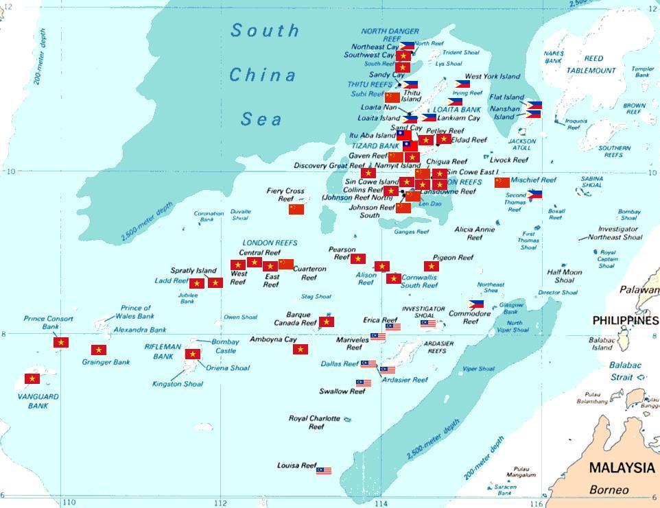
Spratly islands map showing occupied features marked with the flags of countries occupying them.
![]() Philippines
Philippines
![]() Republic of China (Taiwan)
Republic of China (Taiwan)
![]() Vietnam
Vietnam
![]() Malaysia
Malaysia
![]() People's Republic of China
People's Republic of China
The flags are placed such that no text and other flag is overlapped. Hence, some flags are not in the exact coordinates where they should actually lie. However, they still portray the general picture on how Spratly Islands are divided among claimant nations. All occupied features are placed with flags, including those which are not labeled in the map. Here are all unlabeled features:
Ban Than Reef (T) The flag below the flag for Itu Aba Island (T).
Higgens Reef (V) The flag sandwiched between the flags for Sin Cowe Island (V) and Landsowne Reef (V).
Whitson Reef (C) The flag nearest Chigua Reef label. Based on coordinates of Whitson Reef which is 10°00'N 114°43'E, it should lie there.
Kennan Reef (C) The flag nearest the flag for Johnson South Reef (C).


Relevante Bilder
_arrives_at_Fleet_Activities_Yokosuka%2c_Japan.jpg)


Relevante Artikel
Territorialkonflikte im Chinesischen MeerZu Territorialkonflikten im Chinesischen Meer kam es seit den 1950er-Jahren zwischen den Anrainern und weiteren Interessenparteien mit weitreichenden ökonomischen und sicherheitspolitischen Interessen. Die territorialen Grenzen zwischen den Anrainerstaaten sind in vielen Fällen nicht geklärt. Volksrepublik China, Republik China (Taiwan), Japan, Südkorea, Philippinen, Malaysia, Brunei, Indonesien und Vietnam beanspruchen dadurch teilweise dieselben Seegebiete und Inseln. Auslöser der Konflikte sind das Interesse an Rohstoffvorkommen und reichen Fischgründen in den Seegebieten des Südchinesischen und Gelben Meeres. .. weiterlesen