South of the pass on the Kerry Way - geograph.org.uk - 450314
(c) Espresso Addict, CC BY-SA 2.0
Autor/Urheber:
Shortlink:
Quelle:
Größe:
439 x 640 Pixel (129741 Bytes)
Beschreibung:
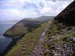
South of the pass on the Kerry Way The Kerry Way climbs to a pass at 377m between Curraghmore (An Currach Mor; 822m) and an unnamed hill (451m), before descending via the zigzags of the Lack Road. This view north east from immediately south of the pass shows (from left to right) Caher West Top, Caher (Cathair) and Curraghmore. The Kerry Way marker post is made from recycled plastic
Lizenz:
Credit:
From geograph.org.uk
Relevante Bilder

(c) Nigel Cox, CC BY-SA 2.0

(c) Rob Burke, CC BY-SA 2.0

(c) Jonathan Billinger, CC BY-SA 2.0

(c) Peter Newbold, CC BY-SA 2.0

(c) Oliver Dixon, CC BY-SA 2.0


Relevante Artikel
Kerry WayDer Kerry Way ist ein Fernwanderweg im County Kerry im Südwesten der Republik Irland. Er ist ein 214 km langer Rundweg, der in der Stadt Killarney beginnt und endet. Üblicherweise wird er in neun Tagesetappen geteilt. Er ist der längste der „National Waymarked Trails“ nach dem System des Irish Sports Council; für die Instandhaltung des Weges sind die örtlichen Behörden des County Kerry zuständig. Der Kerry Way umrundet die Halbinsel Iveragh und orientiert sich im Verlauf damit an der bekannten Straße des Ring of Kerry. .. weiterlesen
