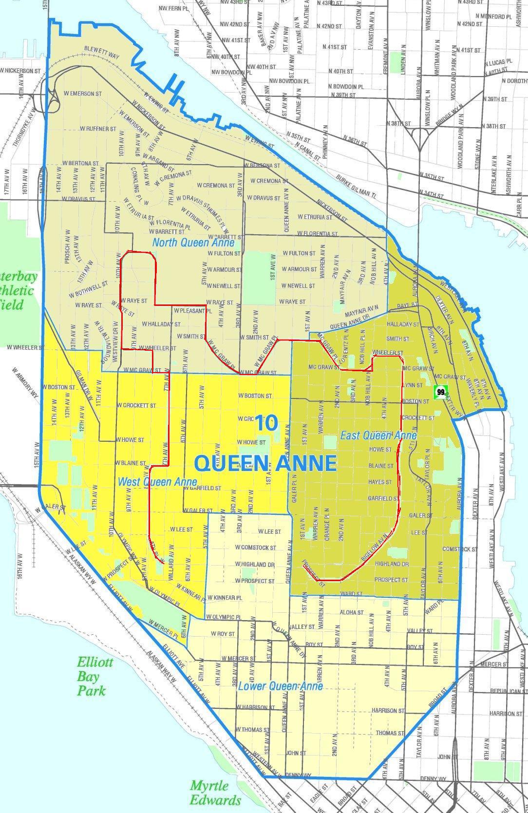
Seattle - Queen Anne Boulevard map
Autor/Urheber:
Office of the Seattle City Clerk
Shortlink:
Quelle:
Größe:
1084 x 1669 Pixel (317746 Bytes)
Beschreibung:
Unofficial map of the Queen Anne neighborhood. Queen Anne Boulevard marked in red. The boulevard has status as a Seattle City landmark.
| Disclaimer: The Seattle Neighborhood Atlas, which the Seattle Clerk's Office has placed in the public domain (as confirmed by OTRS ticket 2008033110016048) contains some general commentary on the maps, "About Maps", which should typically be linked as an accompaniment to these maps to (in their words) "minimize the numerous 'complaints' or comments by users who feel it necessary to point out how the Clerk's Office is 'wrong' about a certain section of town." In particular, "About Maps" says that the atlas "is designed for subject indexing of legislation, photographs, and other documents in the City Clerk's Office and Seattle Municipal Archives" and "is not designed or intended as an 'official' City of Seattle neighborhood map. There are many different ideas of what neighborhood districts exist in Seattle and what their names are…" |
Kommentar zur Lizenz:
PD-Seattle-Neighborhood-Atlas.
Lizenz:
Public domain
Credit:
Image from the Seattle City Clerk's Neighborhood Map Atlas. Queen Anne Boulevard marked in red by User:Jmabel; if that is considered "creative", then he hereby releases all rights to this image into the public domain.
Bild teilen:


Relevante Bilder

(c) Joe Mabel, CC-BY-SA-3.0

(c) Joe Mabel, CC-BY-SA-3.0

(c) Joe Mabel, CC-BY-SA-3.0

(c) Joe Mabel, CC-BY-SA-3.0

(c) Joe Mabel, CC-BY-SA-3.0

(c) Joe Mabel, CC-BY-SA-3.0

(c) Joe Mabel, CC-BY-SA-3.0

(c) I, Jmabel, CC-BY-SA-3.0

(c) Joe Mabel, CC-BY-SA-3.0

(c) Joe Mabel, CC-BY-SA-3.0

(c) Joe Mabel, CC-BY-SA-3.0

(c) Joe Mabel, CC-BY-SA-3.0
(c) Joe Mabel, CC-BY-SA-3.0

(c) Joe Mabel, CC-BY-SA-3.0

(c) Joe Mabel, CC-BY-SA-3.0

(c) Joe Mabel, CC-BY-SA-3.0

(c) Joe Mabel, CC-BY-SA-3.0

(c) Joe Mabel, CC BY-SA 3.0


(c) Joe Mabel, CC-BY-SA-3.0

(c) Joe Mabel, CC-BY-SA-3.0

(c) Joe Mabel, CC-BY-SA-3.0

(c) Joe Mabel, CC BY-SA 3.0

(c) Joe Mabel, CC-BY-SA-3.0

(c) Joe Mabel, CC-BY-SA-3.0

(c) Joe Mabel, CC BY-SA 3.0

(c) Joe Mabel, CC-BY-SA-3.0

(c) Joe Mabel, CC-BY-SA-3.0

(c) Joe Mabel, CC-BY-SA-3.0

(c) Joe Mabel, CC-BY-SA-3.0

(c) Joe Mabel, CC-BY-SA-3.0

(c) Joe Mabel, CC-BY-SA-3.0

(c) Joe Mabel, CC-BY-SA-3.0

(c) Joe Mabel, CC-BY-SA-3.0

(c) Joe Mabel, CC-BY-SA-3.0

(c) Joe Mabel, CC-BY-SA-3.0

(c) Joe Mabel, CC-BY-SA-3.0

(c) Joe Mabel, CC-BY-SA-3.0


(c) Joe Mabel, CC-BY-SA-3.0

(c) Joe Mabel, CC-BY-SA-3.0
Relevante Artikel
Liste der City of Seattle LandmarksDie Liste der City of Seattle Landmarks nennt die vom City of Seattle Landmarks Preservation Board ausgewiesenen Denkmäler in Seattle. .. weiterlesen