Roman.Wales.Forts.Fortlets.Roads
Autor/Urheber:
my work
Attribution:
Das Bild ist mit 'Attribution Required' markiert, aber es wurden keine Informationen über die Attribution bereitgestellt. Vermutlich wurde bei Verwendung des MediaWiki-Templates für die CC-BY Lizenzen der Parameter für die Attribution weggelassen. Autoren und Urheber finden für die korrekte Verwendung der Templates hier ein Beispiel.
Shortlink:
Quelle:
Größe:
2092 x 2798 Pixel (876574 Bytes)
Beschreibung:
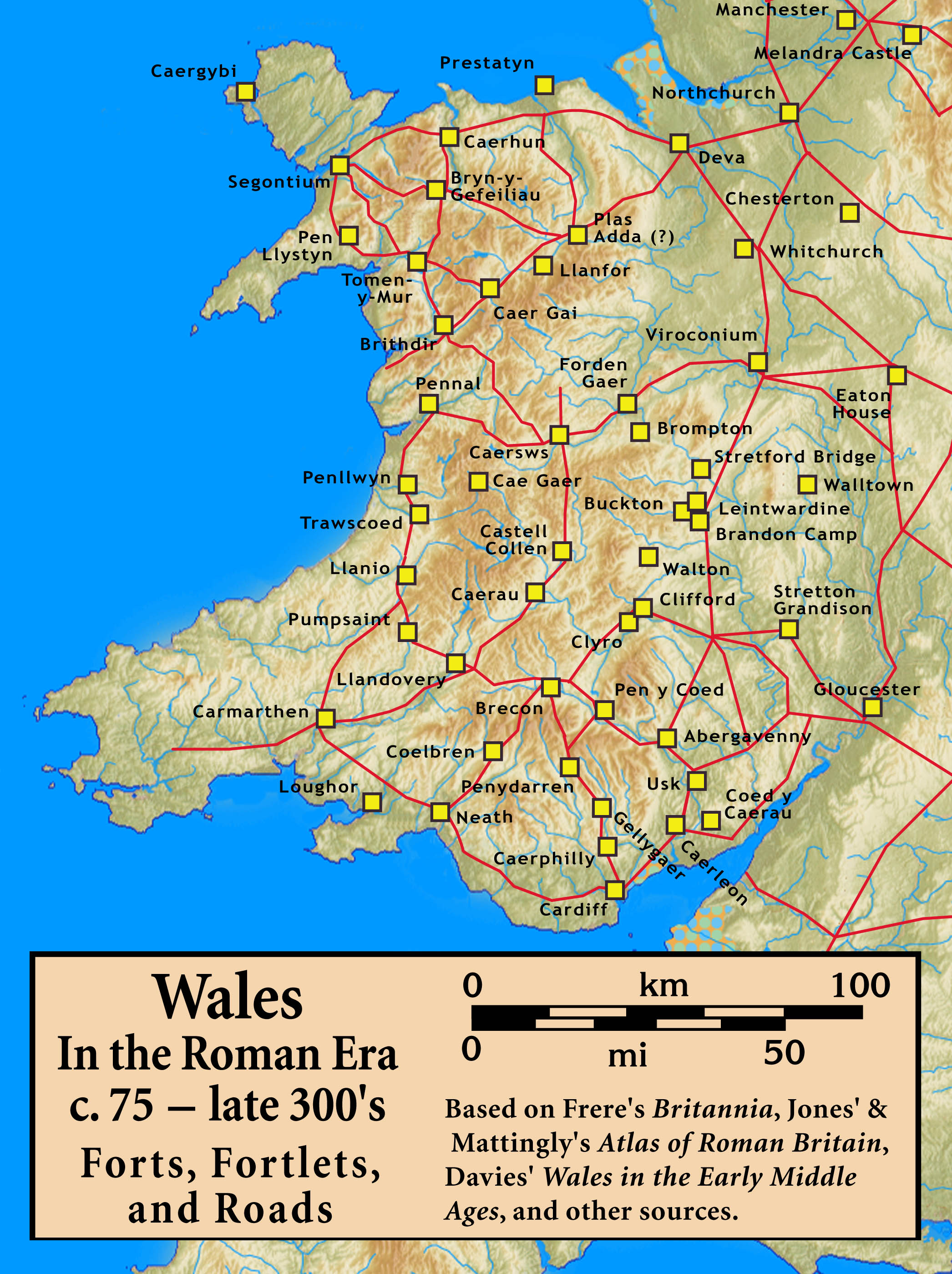
Roman Wales, c. 48 — c. 395: Military Forts, Fortlets, and Roads
Lizenz:
Credit:
Based on Frere's Britannia, Jones' & Mattingly's Atlas of Roman Britain, Davies' Wales in the Early Middle Ages, the Antonine Itinerary, and other sources (roads are incomplete; forts were built/abandoned over time) — sources are cited in the image legend
Bild teilen:


Relevante Bilder


_Rekonstruktion.png)
.jpg)
(c) Classical Numismatic Group, Inc. http://www.cngcoins.com, CC BY-SA 3.0

(c) Chris McKenna (Thryduulf), CC BY-SA 4.0


(c) Classical Numismatic Group, Inc. http://www.cngcoins.com, CC BY-SA 3.0
_reverse.jpg)


(c) Bob Crook, CC BY-SA 2.0


(c) Colin Smith, CC BY-SA 2.0

(c) Jackie Proven, CC BY-SA 2.0

(c) Phil Champion, CC BY-SA 2.0


(c) Dr Richard Murray, CC BY-SA 2.0

(c) PAUL FARMER, CC BY-SA 2.0


.jpg)


_(44517650982).jpg)

(c) Oliver Dixon, CC BY-SA 2.0


Relevante Artikel
Limes BritannicusLimes Britannicus ist der Sammelbegriff für jene Befestigungs- und Wallanlagen, die den Norden, die Küsten und Hauptverkehrswege des römisch besetzten Britannien schützen sollten. Dieser Limesabschnitt existierte vom 1. bis zum 5. Jahrhundert n. Chr. und erstreckte sich auf das Gebiet des heutigen England, Schottland und Wales. .. weiterlesen