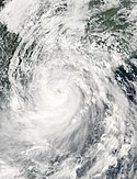
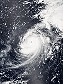
Rammasun Jul 18 2014 0535Z
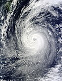
The Moderate Resolution Imaging Spectroradiometer (MODIS) on NASA’s Aqua satellite acquired this image of Typhoon Rammasun at 1:35 p.m. local time (0535 UTC) on July 18, 2014. In the image, the storm has a well-defined eye situated just off the coast of northern Hainan; it is surrounded by bands of thunderstorms stretching across the South China Sea and the Gulf of Tonkin. Shortly before the image was captured, the Joint Typhoon Warning Center reported sustained winds of 125 knots (140 miles or 230 kilometers per hour) and maximum wave heights of 10 meters (35 feet). According to news reports, winds gusted to 160 kilometers (100 miles) per hour in Haikou City, Hainan, a city of 2 million people, and a month’s worth of rain fell in six hours. Chinese meteorologists warned of a storm surge of as much as 6 meters (20 feet). More than one million people were without power in Hainan and Guangdong, and hundreds of thousands of people were evacuated from low-lying areas.
As typically happens when cyclones make landfall, Rammasun broke up a bit and lost strength earlier in the week after passing over the Philippines. But then the storm intensified rapidly over the warm waters of the South China Sea. Such evolution and intensification is a key interest of scientists participating in NASA’s Hurricane and Severe Storm Sentinel (HS3) airborne mission later this summer in the Atlantic Ocean.Relevante Bilder
Relevante Artikel
Pazifische Taifunsaison 2014Die Pazifische Taifunsaison 2014 ist ein Wetterereignis, unter dem alle tropischen Wirbelstürme, die sich während des Kalenderjahres 2014 gebildet haben, zusammengefasst sind. Die meisten tropischen Wirbelstürme bilden sich im Pazifischen Ozean westlich der Datumsgrenze und nördlich des Äquators jedoch zwischen Mai und November. Solche tropischen Wirbelstürme nennt man Taifune. Die sich östlich des 180. Längengrades bildenden Stürme sind Gegenstand der Pazifischen Hurrikansaison 2014. Innerhalb des nordwestlichen Pazifiks gibt es zwei meteorologische Organisationen, die den Stürmen Namen vergeben. Dies führt dazu, dass derselbe Sturm häufig zwei verschiedene Namen erhält. Die offizielle Bezeichnung durch die Japan Meteorological Agency (JMA) erhält ein tropischer Sturm, sobald er an einer beliebigen Stelle im nordwestlichen Pazifik andauernde 10-minütige Windgeschwindigkeiten von 35 Knoten erreicht. Die Philippine Atmospheric, Geophysical and Astronomical Services Administration (PAGASA) hingegen weist tropischen Tiefdruckgebieten Namen zu, die sich innerhalb des nationalen Verantwortungsbereiches bilden oder dorthin ziehen; dieser Verantwortungsbereich liegt grob umgrenzt zwischen 115° und 135° östlicher Länge und zwischen 5° und 25° nördlicher Breite. PAGASA weist auch dann einen lokalen Namen zu, wenn das System bereits durch die Japan Meteorological Agency benannt wurde. Tropische Tiefdruckgebiete, die vom US-amerikanischen Joint Typhoon Warning Center beobachtet werden, erhalten eine Nummer mit dem Suffix W. .. weiterlesen


