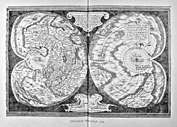
Quam hic vides orbis imagine(m) lector ca(n)dide ea(m) ut posteriore(m) ita ^ eme(n)datiorem ijs que(...) - Norman B. Leventhal Map Center at the BPL


Autor/Urheber:
Attribution:
Das Bild ist mit 'Attribution Required' markiert, aber es wurden keine Informationen über die Attribution bereitgestellt. Vermutlich wurde bei Verwendung des MediaWiki-Templates für die CC-BY Lizenzen der Parameter für die Attribution weggelassen. Autoren und Urheber finden für die korrekte Verwendung der Templates hier ein Beispiel.
Größe:
1200 x 783 Pixel (376802 Bytes)
Beschreibung:

Zoom into this map at maps.bpl.org. Author: Salamanca, Antonio Publisher: [s.n.] Date: [ca. 1550]


Scale: Scale not given ; Call Number: G3200 1550.S25

The Italian engraver and publisher, Antonio Salamanca, who collaborated with Antonio Lafreri to create made-to-order composite map books during the mid-16th century, produced this finely engraved world map utilizing the double cordiform projection (heart shaped). Salamanca's engraving was based on a map published in 1538 by the noted Flemish geographer and map publisher, Gerard Mercator. Mercator's original map, which is now very rare, was similar to Oronce Fine's double cordiform world map published in 1531. However, there were several significant differences, particularly in terms of geographic content. Most importantly, on this map, both North and South America were labeled "America" for the first time. In addition, both parts of the New World were unambiguously linked as one land mass and the northern part was no longer attached to Asia. Amazingly, this was only Mercator's second map publication during his long and productive career. In 1569, he published a large wall map on 21 sheets which introduced the map projection that now bears his name. Although the original map utilizing this projection is very rare, the projection was adopted by other contemporary map makers and continued to be used widely throughout the 19th century. Mercator also published numerous maps and several globes and atlases. It was his book of world maps, first published in 1595 one year after his death, that introduced the term "atlas" to the world.
Lizenz:
Bild teilen:
Facebook   Twitter   Pinterest   WhatsApp   Telegram   E-Mail
Weitere Informationen zur Lizenz des Bildes finden Sie hier. Letzte Aktualisierung: Fri, 14 Oct 2022 05:55:35 GMT

Relevante Bilder


Relevante Artikel

Mercator-Weltkarte von 1538

Die Mercator-Weltkarte von 1538 gilt als eine der frühesten Werke des Kartografen Gerhard Mercator in seiner Zeit in Löwen. Die Karte wurde in herzförmiger Projektion geschaffen und bezeichnet erstmals Nord- und Südamerika einheitlich als Doppelkontinent Amerika. .. weiterlesen