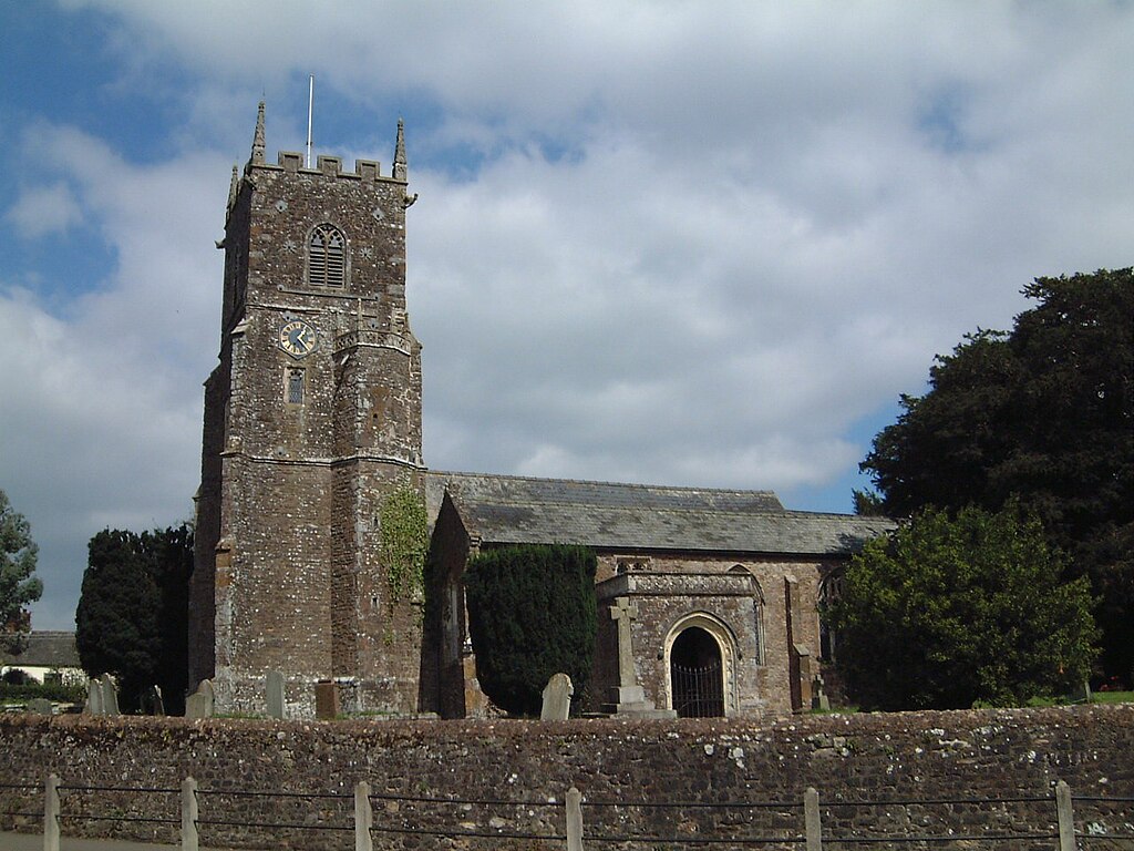
Plymtree, St John
Autor/Urheber:
Attribution:
Das Bild ist mit 'Attribution Required' markiert, aber es wurden keine Informationen über die Attribution bereitgestellt. Vermutlich wurde bei Verwendung des MediaWiki-Templates für die CC-BY Lizenzen der Parameter für die Attribution weggelassen. Autoren und Urheber finden für die korrekte Verwendung der Templates hier ein Beispiel.
Shortlink:
Quelle:
Größe:
1280 x 960 Pixel (260950 Bytes)
Beschreibung:
St John's Church, Plymtree, Devon, circa 2000.
Lizenz:
Relevante Bilder
![](https://upload.wikimedia.org/wikipedia/commons/thumb/8/80/Plymtree_St_John_Ba_eastward_GeoUK_5324542.jpg/250px-Plymtree_St_John_Ba_eastward_GeoUK_5324542.jpg)
![](https://upload.wikimedia.org/wikipedia/commons/thumb/8/83/St_Paul%2C_Deptford_High_Street%2C_London_SE8_-_West_end-geograph-2076186-by-John-Salmon.jpg/250px-St_Paul%2C_Deptford_High_Street%2C_London_SE8_-_West_end-geograph-2076186-by-John-Salmon.jpg)
(c) John Salmon, CC BY-SA 2.0
![](https://upload.wikimedia.org/wikipedia/commons/thumb/c/c4/Eglwys_Santes_Eurgain_a_Sant_Pedr%2C_Llaneurgain_-_Church_of_St_Eurgain_and_St_Paul%2C_Northop%2C_Flintshire_Cymru_Wales_95.jpg/250px-Eglwys_Santes_Eurgain_a_Sant_Pedr%2C_Llaneurgain_-_Church_of_St_Eurgain_and_St_Paul%2C_Northop%2C_Flintshire_Cymru_Wales_95.jpg)
![](https://upload.wikimedia.org/wikipedia/commons/thumb/1/1d/Little_Berkhamsted%2C_Hertfordshire%2C_St_Andrew%27s_Church_09_-_From_the_northeast.jpg/250px-Little_Berkhamsted%2C_Hertfordshire%2C_St_Andrew%27s_Church_09_-_From_the_northeast.jpg)
![](https://upload.wikimedia.org/wikipedia/commons/thumb/f/fc/Little_Berkhamsted%2C_Hertfordshire%2C_St_Andrew%27s_Church_12_-_From_the_northwest.jpg/250px-Little_Berkhamsted%2C_Hertfordshire%2C_St_Andrew%27s_Church_12_-_From_the_northwest.jpg)
![](https://upload.wikimedia.org/wikipedia/commons/thumb/d/dc/Wilberfoss%2C_East_Yorkshire%2C_St_John_the_Baptist_%28geograph_5920488%29.jpg/250px-Wilberfoss%2C_East_Yorkshire%2C_St_John_the_Baptist_%28geograph_5920488%29.jpg)
(c) Dave Kelly, CC BY-SA 2.0
![](https://upload.wikimedia.org/wikipedia/commons/thumb/0/07/188_of_%27The_History_of_Dorchester%2C_Oxfordshire-_British_earthworks-Roman_Camp-Bishopric._And_the_architectural_history_of_the_Church%2C_compiled_from_the_best_authorities._With_a_general_introduction_by_J._H._P%27_%2811154061806%29.jpg/250px-thumbnail.jpg)
![](https://upload.wikimedia.org/wikipedia/commons/thumb/8/8f/Lynton_and_Lynmouth_-_Church_of_St_John_the_Baptist_-_20220926182358.png/250px-Lynton_and_Lynmouth_-_Church_of_St_John_the_Baptist_-_20220926182358.png)
![](https://upload.wikimedia.org/wikipedia/commons/thumb/e/e5/Plymstock_St_Mary_%26_All_Saints_nave_%2B_aisles_eastward_GeoUK_7531043.jpg/250px-Plymstock_St_Mary_%26_All_Saints_nave_%2B_aisles_eastward_GeoUK_7531043.jpg)
(c) Alan Murray-Rust, CC BY-SA 2.0
![](https://upload.wikimedia.org/wikipedia/commons/thumb/a/a7/Church_of_the_Blessed_Virgin_Mary_and_St_Leodegarius%2C_Ashby_St_Ledgers_-_geograph.org.uk_-_3720555.jpg/250px-Church_of_the_Blessed_Virgin_Mary_and_St_Leodegarius%2C_Ashby_St_Ledgers_-_geograph.org.uk_-_3720555.jpg)
(c) Church of the Blessed Virgin Mary and St Leodegarius, Ashby St Ledgers by David Purchase, CC BY-SA 2.0
![](https://upload.wikimedia.org/wikipedia/commons/thumb/c/ca/Holy_Trinity_Church%2C_Milton_Regis%2C_Kent_-_South_aisle_-_geograph.org.uk_-_769398.jpg/125px-Holy_Trinity_Church%2C_Milton_Regis%2C_Kent_-_South_aisle_-_geograph.org.uk_-_769398.jpg)
(c) John Salmon, CC BY-SA 2.0
![](https://upload.wikimedia.org/wikipedia/commons/thumb/c/c5/Rood_Screen%2C_St_John_the_Baptist%2C_East_Down_-_geograph.org.uk_-_729371.jpg/250px-Rood_Screen%2C_St_John_the_Baptist%2C_East_Down_-_geograph.org.uk_-_729371.jpg)
(c) Trish Steel, CC BY-SA 2.0
![](https://upload.wikimedia.org/wikipedia/commons/thumb/9/99/Kirkby_Wharfe%2C_St_John_The_Baptist_Church_-_geograph.org.uk_-_231886.jpg/250px-Kirkby_Wharfe%2C_St_John_The_Baptist_Church_-_geograph.org.uk_-_231886.jpg)
(c) Bill Henderson, CC BY-SA 2.0
![](https://upload.wikimedia.org/wikipedia/commons/thumb/b/b4/Radley%2C_St._James_the_Great_Church%2C_The_nave_with_its_rare_timber_arcade_-_geograph.org.uk_-_5192684.jpg/250px-Radley%2C_St._James_the_Great_Church%2C_The_nave_with_its_rare_timber_arcade_-_geograph.org.uk_-_5192684.jpg)
(c) Radley, St. James the Great Church: The nave with its rare timber arcade by Michael Garlick, CC BY-SA 2.0
![](https://upload.wikimedia.org/wikipedia/commons/thumb/c/c3/Holcombe_Burnell_St_John_GeoUK_164111_cropped.jpg/250px-Holcombe_Burnell_St_John_GeoUK_164111_cropped.jpg)
![](https://upload.wikimedia.org/wikipedia/commons/thumb/d/d4/Eglwys_Sant_Trillo_-_St_Trillo%27s_Church%2C_Llandrillo_yn_Rhos%2C_Conwy%2C_Wales_24.jpg/250px-Eglwys_Sant_Trillo_-_St_Trillo%27s_Church%2C_Llandrillo_yn_Rhos%2C_Conwy%2C_Wales_24.jpg)
![](https://upload.wikimedia.org/wikipedia/commons/thumb/e/e9/Hagley_Worcs_-_St_John_the_Baptist_-_exterior_from_east_02.jpg/125px-Hagley_Worcs_-_St_John_the_Baptist_-_exterior_from_east_02.jpg)
![](https://upload.wikimedia.org/wikipedia/commons/thumb/0/09/179_of_%27History_of_the_Parish_of_Ecclesfield%2C_in_the_county_of_York%27_%2811063483953%29.jpg/250px-179_of_%27History_of_the_Parish_of_Ecclesfield%2C_in_the_county_of_York%27_%2811063483953%29.jpg)
![](https://upload.wikimedia.org/wikipedia/commons/thumb/1/15/St._John_the_Baptist_church%2C_Stanton_St._John_-_geograph.org.uk_-_673357.jpg/250px-St._John_the_Baptist_church%2C_Stanton_St._John_-_geograph.org.uk_-_673357.jpg)
(c) Jonathan Billinger, CC BY-SA 2.0
![](https://upload.wikimedia.org/wikipedia/commons/thumb/5/5a/Holy_Trinity_Church_of_Ireland%2C_Portrush_-_geograph.org.uk_-_222864.jpg/250px-Holy_Trinity_Church_of_Ireland%2C_Portrush_-_geograph.org.uk_-_222864.jpg)
(c) Kenneth Allen, CC BY-SA 2.0
![](https://upload.wikimedia.org/wikipedia/commons/thumb/4/49/Parish_Church_of_St_Peter%2C_Stoke_Goldington_-_geograph.org.uk_-_249488.jpg/250px-Parish_Church_of_St_Peter%2C_Stoke_Goldington_-_geograph.org.uk_-_249488.jpg)
(c) Chris Walpole, CC BY-SA 2.0
![](https://upload.wikimedia.org/wikipedia/commons/thumb/d/db/St_John_the_Baptist%2C_Stanton_St_John_-_geograph.org.uk_-_1780575.jpg/250px-St_John_the_Baptist%2C_Stanton_St_John_-_geograph.org.uk_-_1780575.jpg)
(c) Stephen Craven, CC BY-SA 2.0
![](https://upload.wikimedia.org/wikipedia/commons/thumb/f/ff/Willesborough%2C_St_Mary_the_Virgin_2%28credit_St_Mary_the_Virgin_chuch%29_%2850251062496%29.jpg/250px-Willesborough%2C_St_Mary_the_Virgin_2%28credit_St_Mary_the_Virgin_chuch%29_%2850251062496%29.jpg)
![](https://upload.wikimedia.org/wikipedia/commons/thumb/5/56/St_Martin%27s_Church%2C_Herne%2C_Kent_-_South_aisle_-_geograph.org.uk_-_857969.jpg/250px-St_Martin%27s_Church%2C_Herne%2C_Kent_-_South_aisle_-_geograph.org.uk_-_857969.jpg)
(c) John Salmon, CC BY-SA 2.0
![](https://upload.wikimedia.org/wikipedia/commons/thumb/9/96/St.Katherine%27s_church%2C_Loversall%2C_South_Yorkshire._-_geograph.org.uk_-_104969.jpg/250px-St.Katherine%27s_church%2C_Loversall%2C_South_Yorkshire._-_geograph.org.uk_-_104969.jpg)
(c) Richard Croft, CC BY-SA 2.0
![](https://upload.wikimedia.org/wikipedia/commons/thumb/e/e5/-2016-04-27_Looking_east_along_the_nave%2C_Saint_Nicholas_parish_church%2C_Great_Yarmouth%2C_Norfolk.jpg/250px--2016-04-27_Looking_east_along_the_nave%2C_Saint_Nicholas_parish_church%2C_Great_Yarmouth%2C_Norfolk.jpg)
(c) John Salmon, CC BY-SA 2.0
![](https://upload.wikimedia.org/wikipedia/commons/thumb/d/df/Holy_Cross%2C_Bearsted%2C_Kent_-_East_end_-_geograph.org.uk_-_325333.jpg/250px-Holy_Cross%2C_Bearsted%2C_Kent_-_East_end_-_geograph.org.uk_-_325333.jpg)
(c) John Salmon, CC BY-SA 2.0
![](https://upload.wikimedia.org/wikipedia/commons/thumb/4/49/Bovey_Tracey_-_St_Peter%2C_St_Paul_and_St_Thomas_Church_%28geograph_3597197%29.jpg/250px-Bovey_Tracey_-_St_Peter%2C_St_Paul_and_St_Thomas_Church_%28geograph_3597197%29.jpg)
(c) Lewis Clarke, CC BY-SA 2.0
![](https://upload.wikimedia.org/wikipedia/commons/thumb/6/61/Swymbridge_-_Interior_%28John_Stabb%29.png/250px-Swymbridge_-_Interior_%28John_Stabb%29.png)
![](https://upload.wikimedia.org/wikipedia/commons/thumb/e/e8/Church_of_the_Nativity_of_the_Blessed_Virgin_Mary%2C_Studley_-_geograph.org.uk_-_161604.jpg/250px-Church_of_the_Nativity_of_the_Blessed_Virgin_Mary%2C_Studley_-_geograph.org.uk_-_161604.jpg)
(c) David Stowell, CC BY-SA 2.0
![](https://upload.wikimedia.org/wikipedia/commons/thumb/f/fb/Willesborough%2C_St_Mary_the_Virgin_%28credit_St_Mary_the_Virgin_chuch%29_%2850251253987%29.jpg/250px-Willesborough%2C_St_Mary_the_Virgin_%28credit_St_Mary_the_Virgin_chuch%29_%2850251253987%29.jpg)
![](https://upload.wikimedia.org/wikipedia/commons/thumb/3/34/Kirk_Hammerton%2C_St_John%27s_Church_-_geograph.org.uk_-_4058602.jpg/250px-Kirk_Hammerton%2C_St_John%27s_Church_-_geograph.org.uk_-_4058602.jpg)
(c) Kirk Hammerton, St John's Church by David Dixon, CC BY-SA 2.0
![](https://upload.wikimedia.org/wikipedia/commons/thumb/8/8e/Ashreigney%2C_south_aisle%2C_St_James%27s_church_-_geograph.org.uk_-_606497.jpg/125px-Ashreigney%2C_south_aisle%2C_St_James%27s_church_-_geograph.org.uk_-_606497.jpg)
(c) Martin Bodman, CC BY-SA 2.0
![](https://upload.wikimedia.org/wikipedia/commons/thumb/1/15/St_James_the_Greater%2C_Dadlington_-_East_end_-_geograph.org.uk_-_4470628.jpg/250px-St_James_the_Greater%2C_Dadlington_-_East_end_-_geograph.org.uk_-_4470628.jpg)
(c) St James the Greater, Dadlington - East end by John Salmon, CC BY-SA 2.0
![](https://upload.wikimedia.org/wikipedia/commons/thumb/e/ed/St_Thomas_the_Apostle_Church%2C_Stanhope_-_geograph.org.uk_-_2259652.jpg/250px-St_Thomas_the_Apostle_Church%2C_Stanhope_-_geograph.org.uk_-_2259652.jpg)
(c) St Thomas the Apostle Church, Stanhope by Carol Bleasdale, CC BY-SA 2.0
![](https://upload.wikimedia.org/wikipedia/commons/thumb/5/55/St_Michael_at_the_North_Gate%2C_Cornmarket_Street%2C_Oxford_-_geograph.org.uk_-_2873558.jpg/250px-St_Michael_at_the_North_Gate%2C_Cornmarket_Street%2C_Oxford_-_geograph.org.uk_-_2873558.jpg)
(c) St Michael at the North Gate, Cornmarket Street, Oxford by Robin Sones, CC BY-SA 2.0
![](https://upload.wikimedia.org/wikipedia/commons/thumb/9/90/Milton_Damerel_-_interior_%28John_Stabb%29.jpg/250px-Milton_Damerel_-_interior_%28John_Stabb%29.jpg)
![](https://upload.wikimedia.org/wikipedia/commons/thumb/b/b6/St_Peter_^_St_Paul%2C_Peasmarsh%2C_Sussex_-_East_end_-_geograph.org.uk_-_1926163.jpg/250px-St_Peter_^_St_Paul%2C_Peasmarsh%2C_Sussex_-_East_end_-_geograph.org.uk_-_1926163.jpg)
(c) St Peter & St Paul, Peasmarsh, Sussex - East end by John Salmon, CC BY-SA 2.0
![](https://upload.wikimedia.org/wikipedia/commons/thumb/7/79/Holy_Trinity_Church%2C_Milton_Regis%2C_Kent_-_Chancel_-_geograph.org.uk_-_769383.jpg/125px-Holy_Trinity_Church%2C_Milton_Regis%2C_Kent_-_Chancel_-_geograph.org.uk_-_769383.jpg)
(c) John Salmon, CC BY-SA 2.0
![](https://upload.wikimedia.org/wikipedia/commons/thumb/6/66/St_Clement%27s_church_-_the_east_end_of_the_nave_-_geograph.org.uk_-_865926.jpg/250px-St_Clement%27s_church_-_the_east_end_of_the_nave_-_geograph.org.uk_-_865926.jpg)
(c) Evelyn Simak, CC BY-SA 2.0
Relevante Artikel
Liste der Hallenkirchen im Vereinigten Königreich▶ Liste(n) der Hallenkirchen – Übersicht .. weiterlesen