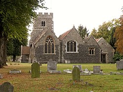
Plan of 'The Cathedral in the Forest' - geograph.org.uk - 908538
(c) Pauline Eccles, CC BY-SA 2.0
Autor/Urheber:
Shortlink:
Quelle:
Größe:
640 x 478 Pixel (126276 Bytes)
Beschreibung:
Plan of 'The Cathedral in the Forest' As All Saints Church is known locally. I include the plan as it is such a surprise to find this very large church in such a small village.
Lizenz:
Credit:
From geograph.org.uk
Relevante Bilder
![](https://upload.wikimedia.org/wikipedia/commons/thumb/e/ea/Parish_Church_of_Saint_Peter%2C_Bickenhill_in_the_Birmingham_Diocese_-_geograph.org.uk_-_90351.jpg/125px-Parish_Church_of_Saint_Peter%2C_Bickenhill_in_the_Birmingham_Diocese_-_geograph.org.uk_-_90351.jpg)
(c) peter lloyd, CC BY-SA 2.0
![](https://upload.wikimedia.org/wikipedia/commons/thumb/5/5e/Yarnton%2C_St._Bartholomew%27s_Church%2C_The_nave_with_its_unusual_chancel_arch_and_c15th_painting_-_geograph.org.uk_-_5196508.jpg/250px-Yarnton%2C_St._Bartholomew%27s_Church%2C_The_nave_with_its_unusual_chancel_arch_and_c15th_painting_-_geograph.org.uk_-_5196508.jpg)
(c) Yarnton, St. Bartholomew's Church: The nave with its unusual chancel arch and c15th painting by Michael Garlick, CC BY-SA 2.0
![](https://upload.wikimedia.org/wikipedia/commons/thumb/a/a7/Church_of_the_Blessed_Virgin_Mary_and_St_Leodegarius%2C_Ashby_St_Ledgers_-_geograph.org.uk_-_3720555.jpg/250px-Church_of_the_Blessed_Virgin_Mary_and_St_Leodegarius%2C_Ashby_St_Ledgers_-_geograph.org.uk_-_3720555.jpg)
(c) Church of the Blessed Virgin Mary and St Leodegarius, Ashby St Ledgers by David Purchase, CC BY-SA 2.0
![](https://upload.wikimedia.org/wikipedia/commons/thumb/c/c6/Interior_of_the_Church_of_St_Mary_Magdalene%2C_Great_Burstead_-_geograph.org.uk_-_1418536.jpg/250px-Interior_of_the_Church_of_St_Mary_Magdalene%2C_Great_Burstead_-_geograph.org.uk_-_1418536.jpg)
(c) Derek Voller, CC BY-SA 2.0
![](https://upload.wikimedia.org/wikipedia/commons/thumb/b/b4/Radley%2C_St._James_the_Great_Church%2C_The_nave_with_its_rare_timber_arcade_-_geograph.org.uk_-_5192684.jpg/250px-Radley%2C_St._James_the_Great_Church%2C_The_nave_with_its_rare_timber_arcade_-_geograph.org.uk_-_5192684.jpg)
(c) Radley, St. James the Great Church: The nave with its rare timber arcade by Michael Garlick, CC BY-SA 2.0
![](https://upload.wikimedia.org/wikipedia/commons/thumb/8/8f/Arches_of_south_aisle%2C_All_Saints_church%2C_Thurlestone_-_geograph.org.uk_-_5028200.jpg/125px-Arches_of_south_aisle%2C_All_Saints_church%2C_Thurlestone_-_geograph.org.uk_-_5028200.jpg)
(c) Arches of south aisle, All Saints church, Thurlestone by David Smith, CC BY-SA 2.0
![](https://upload.wikimedia.org/wikipedia/commons/thumb/6/6a/Interior_of_the_Church_of_St_Michael_^_St_James%2C_Linby_cum_Papplewick_-_geograph.org.uk_-_4331498.jpg/250px-Interior_of_the_Church_of_St_Michael_^_St_James%2C_Linby_cum_Papplewick_-_geograph.org.uk_-_4331498.jpg)
(c) Interior of the Church of St Michael & St James, Linby cum Papplewick by Dave Hitchborne, CC BY-SA 2.0
![](https://upload.wikimedia.org/wikipedia/commons/thumb/f/fc/The_church_of_SS_Peter_and_Paul_in_Wangford_-_view_west_-_geograph.org.uk_-_2078325.jpg/250px-The_church_of_SS_Peter_and_Paul_in_Wangford_-_view_west_-_geograph.org.uk_-_2078325.jpg)
(c) The church of SS Peter and Paul in Wangford - view west by Evelyn Simak, CC BY-SA 2.0
![](https://upload.wikimedia.org/wikipedia/commons/thumb/3/3d/The_church_of_SS_Peter_and_Paul_in_Wisbech_-_south_aisle_-_geograph.org.uk_-_1828248.jpg/125px-The_church_of_SS_Peter_and_Paul_in_Wisbech_-_south_aisle_-_geograph.org.uk_-_1828248.jpg)
(c) The church of SS Peter and Paul in Wisbech - south aisle by Evelyn Simak, CC BY-SA 2.0
![](https://upload.wikimedia.org/wikipedia/commons/thumb/9/98/Church_of_St_John_Lateran_%28or_The_Reconciliation%29_-_geograph.org.uk_-_725356.jpg/250px-Church_of_St_John_Lateran_%28or_The_Reconciliation%29_-_geograph.org.uk_-_725356.jpg)
(c) James Yardley, CC BY-SA 2.0
![](https://upload.wikimedia.org/wikipedia/commons/thumb/c/cd/Parish_Church_of_St._Michael_and_All_Angels%2C_Linton%2C_Yorkshire_-_geograph.org.uk_-_879367.jpg/250px-Parish_Church_of_St._Michael_and_All_Angels%2C_Linton%2C_Yorkshire_-_geograph.org.uk_-_879367.jpg)
(c) Dr Neil Clifton, CC BY-SA 2.0
![](https://upload.wikimedia.org/wikipedia/commons/thumb/9/97/Rippingale_St._Andrews%27_Church_internal_view_towards_altar_-_geograph.org.uk_-_2608040.jpg/250px-Rippingale_St._Andrews%27_Church_internal_view_towards_altar_-_geograph.org.uk_-_2608040.jpg)
(c) Rippingale St. Andrews' Church internal view towards altar by JOHN BLAKESTON, CC BY-SA 2.0
![](https://upload.wikimedia.org/wikipedia/commons/thumb/5/55/St_Michael_at_the_North_Gate%2C_Cornmarket_Street%2C_Oxford_-_geograph.org.uk_-_2873558.jpg/250px-St_Michael_at_the_North_Gate%2C_Cornmarket_Street%2C_Oxford_-_geograph.org.uk_-_2873558.jpg)
(c) St Michael at the North Gate, Cornmarket Street, Oxford by Robin Sones, CC BY-SA 2.0
![](https://upload.wikimedia.org/wikipedia/commons/thumb/3/38/St_John_the_Baptist%2C_Wittersham_-_interior_looking_south-east_-_geograph.org.uk_-_3963492.jpg/250px-St_John_the_Baptist%2C_Wittersham_-_interior_looking_south-east_-_geograph.org.uk_-_3963492.jpg)
(c) St John the Baptist, Wittersham - interior looking south-east by David Kemp, CC BY-SA 2.0
![](https://upload.wikimedia.org/wikipedia/commons/thumb/3/39/St_Mary%27s_Petworth-_looking_from_the_balcony_down_into_the_nave_-_geograph.org.uk_-_1879106.jpg/250px-St_Mary%27s_Petworth-_looking_from_the_balcony_down_into_the_nave_-_geograph.org.uk_-_1879106.jpg)
(c) St Mary's Petworth- looking from the balcony down into the nave by Basher Eyre, CC BY-SA 2.0
![](https://upload.wikimedia.org/wikipedia/commons/thumb/2/25/A_perambulation_around_Sheffield%27s_Anglican_Cathedral_%2837%29_-_geograph.org.uk_-_2983153.jpg/125px-A_perambulation_around_Sheffield%27s_Anglican_Cathedral_%2837%29_-_geograph.org.uk_-_2983153.jpg)
(c) A perambulation around Sheffield's Anglican Cathedral (37) by Basher Eyre, CC BY-SA 2.0
![](https://upload.wikimedia.org/wikipedia/commons/thumb/6/6f/The_Church_of_Saint_Bartholomew%2C_Upper_Penn%2C_Staffordshire_-_geograph.org.uk_-_616850.jpg/125px-The_Church_of_Saint_Bartholomew%2C_Upper_Penn%2C_Staffordshire_-_geograph.org.uk_-_616850.jpg)
(c) Roger Kidd, CC BY-SA 2.0
![](https://upload.wikimedia.org/wikipedia/commons/thumb/a/aa/Abbots_Langley_-_The_Church_of_St_Lawrence_the_Martyr_-_geograph.org.uk_-_272827.jpg/250px-Abbots_Langley_-_The_Church_of_St_Lawrence_the_Martyr_-_geograph.org.uk_-_272827.jpg)
(c) Nigel Cox, CC BY-SA 2.0
![](https://upload.wikimedia.org/wikipedia/commons/thumb/a/a8/Langford%2C_St._Matthew%27s_Church%2C_c12th_nave_with_Anglo_Saxon_tower_arch_-_geograph.org.uk_-_5441779.jpg/250px-Langford%2C_St._Matthew%27s_Church%2C_c12th_nave_with_Anglo_Saxon_tower_arch_-_geograph.org.uk_-_5441779.jpg)
(c) Langford, St. Matthew's Church: c12th nave with Anglo Saxon tower arch by Michael Garlick, CC BY-SA 2.0
![](https://upload.wikimedia.org/wikipedia/commons/thumb/e/e8/Church_of_the_Nativity_of_the_Blessed_Virgin_Mary%2C_Studley_-_geograph.org.uk_-_161604.jpg/250px-Church_of_the_Nativity_of_the_Blessed_Virgin_Mary%2C_Studley_-_geograph.org.uk_-_161604.jpg)
(c) David Stowell, CC BY-SA 2.0
![](https://upload.wikimedia.org/wikipedia/commons/thumb/c/c2/London_%2C_Tower_Hamlets_-_Tower_of_London%2C_White_Tower_-_geograph.org.uk_-_2062894.jpg/250px-London_%2C_Tower_Hamlets_-_Tower_of_London%2C_White_Tower_-_geograph.org.uk_-_2062894.jpg)
(c) London : Tower Hamlets - Tower of London, White Tower by Lewis Clarke, CC BY-SA 2.0
![](https://upload.wikimedia.org/wikipedia/commons/thumb/6/6b/St_Martin_in_the_Fields%2C_Trafalgar_Square_-_East_end_-_geograph.org.uk_-_999983.jpg/250px-St_Martin_in_the_Fields%2C_Trafalgar_Square_-_East_end_-_geograph.org.uk_-_999983.jpg)
(c) John Salmon, CC BY-SA 2.0
![](https://upload.wikimedia.org/wikipedia/commons/thumb/7/7c/Interior_of_the_Church_of_St_Mary_Le_Wigford%2C_Lincoln_-_geograph.org.uk_-_690431.jpg/250px-Interior_of_the_Church_of_St_Mary_Le_Wigford%2C_Lincoln_-_geograph.org.uk_-_690431.jpg)
(c) Dave Hitchborne, CC BY-SA 2.0
![](https://upload.wikimedia.org/wikipedia/commons/thumb/e/ed/Sullington_St_Mary_-_west_end_of_the_northern_aisle_-_geograph.org.uk_-_2513914.jpg/125px-Sullington_St_Mary_-_west_end_of_the_northern_aisle_-_geograph.org.uk_-_2513914.jpg)
(c) North end of Sullington church by Shazz, CC BY-SA 2.0
![](https://upload.wikimedia.org/wikipedia/commons/thumb/2/2e/Interior%2C_Church_of_St_Peter_and_St_Paul%2C_Broadhempston_-_geograph.org.uk_-_946113.jpg/125px-Interior%2C_Church_of_St_Peter_and_St_Paul%2C_Broadhempston_-_geograph.org.uk_-_946113.jpg)
(c) Trish Steel, CC BY-SA 2.0
![](https://upload.wikimedia.org/wikipedia/commons/thumb/8/8d/The_Parish_Church_of_St_John_the_Baptist%2C_Aston_Cantlow_-_geograph.org.uk_-_2548054.jpg/250px-The_Parish_Church_of_St_John_the_Baptist%2C_Aston_Cantlow_-_geograph.org.uk_-_2548054.jpg)
(c) The Parish Church of St John the Baptist, Aston Cantlow by David Dixon, CC BY-SA 2.0
![](https://upload.wikimedia.org/wikipedia/commons/thumb/9/96/St.Katherine%27s_church%2C_Loversall%2C_South_Yorkshire._-_geograph.org.uk_-_104969.jpg/250px-St.Katherine%27s_church%2C_Loversall%2C_South_Yorkshire._-_geograph.org.uk_-_104969.jpg)
(c) Richard Croft, CC BY-SA 2.0
![](https://upload.wikimedia.org/wikipedia/commons/thumb/0/0f/The_Nave_of_St._Nectan%27s_church%2C_Stoke_near_Hartland%2C_Devon_-_geograph.org.uk_-_4704070.jpg/250px-The_Nave_of_St._Nectan%27s_church%2C_Stoke_near_Hartland%2C_Devon_-_geograph.org.uk_-_4704070.jpg)
(c) The Nave of St. Nectan's church, Stoke near Hartland, Devon by Derek Voller, CC BY-SA 2.0
![](https://upload.wikimedia.org/wikipedia/commons/thumb/9/97/St_Michael_at_the_North_Gate%2C_Oxford_-_North_aisle_-_geograph.org.uk_-_2181881.jpg/250px-St_Michael_at_the_North_Gate%2C_Oxford_-_North_aisle_-_geograph.org.uk_-_2181881.jpg)
(c) St Michael at the North Gate, Oxford - North aisle by John Salmon, CC BY-SA 2.0
![](https://upload.wikimedia.org/wikipedia/commons/thumb/6/61/St._Mary_Magdalene%2C_the_parish_church_of_North_Ockendon_-_geograph.org.uk_-_1517834.jpg/250px-St._Mary_Magdalene%2C_the_parish_church_of_North_Ockendon_-_geograph.org.uk_-_1517834.jpg)
(c) Robert Edwards, CC BY-SA 2.0
![](https://upload.wikimedia.org/wikipedia/commons/thumb/c/c2/The_new_organ_and_millennium_carpet_in_St._Helen%27s_Church_-_geograph.org.uk_-_1520636.jpg/250px-The_new_organ_and_millennium_carpet_in_St._Helen%27s_Church_-_geograph.org.uk_-_1520636.jpg)
(c) johnfromnotts, CC BY-SA 2.0
![](https://upload.wikimedia.org/wikipedia/commons/thumb/b/bf/Church_of_Ss._Peter_and_Paul%2C_Edenbridge_-_interior_-_geograph.org.uk_-_2039847.jpg/250px-Church_of_Ss._Peter_and_Paul%2C_Edenbridge_-_interior_-_geograph.org.uk_-_2039847.jpg)
(c) Ruth Sharville, CC BY-SA 2.0
![](https://upload.wikimedia.org/wikipedia/commons/thumb/d/dc/St_Laurence%27s_Church%2C_Adwick_le_Street_from_Church_Road_-_geograph.org.uk_-_1065437.jpg/250px-St_Laurence%27s_Church%2C_Adwick_le_Street_from_Church_Road_-_geograph.org.uk_-_1065437.jpg)
(c) Steve F, CC BY-SA 2.0
![](https://upload.wikimedia.org/wikipedia/commons/thumb/1/1c/Whitgift_Church_on_the_banks_of_the_River_Ouse_-_geograph.org.uk_-_88272.jpg/250px-Whitgift_Church_on_the_banks_of_the_River_Ouse_-_geograph.org.uk_-_88272.jpg)
(c) Gordon Kneale Brooke, CC BY-SA 2.0
![](https://upload.wikimedia.org/wikipedia/commons/thumb/1/12/St_Michael_and_All_Angels_parish_church_in_Steventon_-_geograph.org.uk_-_1257117.jpg/250px-St_Michael_and_All_Angels_parish_church_in_Steventon_-_geograph.org.uk_-_1257117.jpg)
(c) Steve Daniels, CC BY-SA 2.0
![](https://upload.wikimedia.org/wikipedia/commons/thumb/6/6e/St_John_the_Baptist%2C_Bishopsteignton%2C_Devon_-_East_end_-_geograph.org.uk_-_1727532.jpg/250px-St_John_the_Baptist%2C_Bishopsteignton%2C_Devon_-_East_end_-_geograph.org.uk_-_1727532.jpg)
(c) John Salmon, CC BY-SA 2.0
![](https://upload.wikimedia.org/wikipedia/commons/thumb/1/1e/St_Mary%27s%2C_Thornton-le-Moors%2C_from_the_graveyard_-_geograph.org.uk_-_957190.jpg/250px-St_Mary%27s%2C_Thornton-le-Moors%2C_from_the_graveyard_-_geograph.org.uk_-_957190.jpg)
(c) John Lord, CC BY-SA 2.0
![](https://upload.wikimedia.org/wikipedia/commons/thumb/8/8a/Interior_of_St_Michaels_Church_Pinhoe_Exeter_-_geograph.org.uk_-_906190.jpg/250px-Interior_of_St_Michaels_Church_Pinhoe_Exeter_-_geograph.org.uk_-_906190.jpg)
(c) Liz Moon, CC BY-SA 2.0
![](https://upload.wikimedia.org/wikipedia/commons/thumb/c/ca/Holy_Trinity_Church%2C_Milton_Regis%2C_Kent_-_South_aisle_-_geograph.org.uk_-_769398.jpg/125px-Holy_Trinity_Church%2C_Milton_Regis%2C_Kent_-_South_aisle_-_geograph.org.uk_-_769398.jpg)
(c) John Salmon, CC BY-SA 2.0
![](https://upload.wikimedia.org/wikipedia/commons/thumb/0/0f/The_church_of_St._Mary_Magdalene%2C_Great_Burstead%2C_Essex_-_geograph.org.uk_-_1420669.jpg/125px-The_church_of_St._Mary_Magdalene%2C_Great_Burstead%2C_Essex_-_geograph.org.uk_-_1420669.jpg)
(c) Derek Voller, CC BY-SA 2.0
![](https://upload.wikimedia.org/wikipedia/commons/thumb/1/15/St_James_the_Greater%2C_Dadlington_-_East_end_-_geograph.org.uk_-_4470628.jpg/250px-St_James_the_Greater%2C_Dadlington_-_East_end_-_geograph.org.uk_-_4470628.jpg)
(c) St James the Greater, Dadlington - East end by John Salmon, CC BY-SA 2.0
![](https://upload.wikimedia.org/wikipedia/commons/thumb/6/6f/The_Church_of_St_Luke_and_All_Saints%2C_Darrington_-_geograph.org.uk_-_1859700.jpg/250px-The_Church_of_St_Luke_and_All_Saints%2C_Darrington_-_geograph.org.uk_-_1859700.jpg)
(c) The Church of St Luke and All Saints, Darrington by Alexander P Kapp, CC BY-SA 2.0
Relevante Artikel
Liste der Hallenkirchen im Vereinigten Königreich▶ Liste(n) der Hallenkirchen – Übersicht .. weiterlesen