Pelican Island Galveston
Autor/Urheber:
U.S. Army Corps of Engineers, photographer not specified or unknown
Shortlink:
Quelle:
Größe:
1500 x 1001 Pixel (695570 Bytes)
Beschreibung:
Aerial view of Pelican Island, an island off the northeastern end of Galveston Island. Pelican Island was largely built up by material dredged from the Galveston Ship Channel and the Houston Ship Channel by the U.S. Army Corps of Engineers. The end of Galveston Island, the main part of the city of Galveston, and the Galveston Ship Channel are visible in this photograph. View is to the northeast.
Kommentar zur Lizenz:
This image or file is a work of a U.S. Army Corps of Engineers soldier or employee, taken or made as part of that person's official duties. As a work of the U.S. federal government, the image is in the public domain.
Lizenz:
Public domain
Credit:
U.S. Army Corps of Engineers Digital Visual Library
Image page
Image description page
Digital Visual Library home page
Image page
Image description page
Digital Visual Library home page
Relevante Bilder
Relevante Artikel
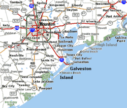
Galveston IslandGalveston Island ist eine aus einer Sandbank entstandene Insel an der texanischen Küste und liegt etwa 80 km südöstlich von Houston. Die Insel liegt mit Ausnahme der Siedlung Jamaica Beach innerhalb der Stadtgrenzen von Galveston. .. weiterlesen


